Cheviot, New Zealand facts for kids
Quick facts for kids
Cheviot
|
|
|---|---|
|
Town
|
|
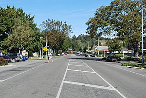
Hall St (State Highway 1), the main street of Cheviot
|
|
| Country | New Zealand |
| Region | Canterbury |
| Territorial authority | Hurunui District |
| Ward | East Ward |
| Electorates |
|
| Area | |
| • Total | 1.05 km2 (0.41 sq mi) |
| Elevation | 60 m (200 ft) |
| Population
(June 2023)
|
|
| • Total | 360 |
| • Density | 343/km2 (888/sq mi) |
| Time zone | UTC+12 (New Zealand Standard Time) |
| • Summer (DST) | UTC+13 (New Zealand Daylight Time) |
| Postcode |
7310
|
| Area code(s) | 03 |
| Local iwi | Ngāi Tahu |
Cheviot is a small town in the Hurunui District of northern Canterbury, New Zealand. It is located on the east coast of the South Island. You can find Cheviot on State Highway 1. It is about 112 kilometers (70 miles) north of Christchurch. It is also about 68 kilometers (42 miles) south of Kaikōura.
Contents
Cheviot's Story: How the Town Got Its Name
The land where Cheviot now stands was once a large estate. It was called Cheviot Hills. The government bought this land between 1892 and 1893. This happened under the Minister of Lands, John McKenzie.
The big estate was then divided into 54 farms. A new town was also created. This town was first named McKenzie, after the minister. People used this name for about ten to twenty years. However, the name Cheviot slowly became more popular. The local post office was always known as Cheviot. By 1913, the town was generally called Cheviot too.
The original owner of the Cheviot Hills estate named it. He was John Scott Caverhill. He named it after his home area, the Cheviot Hills. These hills are found on the border between England and Scotland.
Major Events in Cheviot's History
In 1901, a strong earthquake hit near Cheviot. It measured 6.9 on the scale. Many buildings were damaged. Sadly, one person died.
The old house on the Robinson homestead burned down in 1936. Its foundations and gardens became part of the Cheviot Hills Domain. The original front steps of the house are now part of the cricket pavilion.
In 1971, the Cheviot County rural water supply opened. This project cost $420,000. It brings water to a large area of 128,000 acres. This is done through 190 miles of pipes. A fountain was built outside the local school to celebrate this event.
Who Lives in Cheviot?
Cheviot is considered a rural settlement by Statistics New Zealand. It covers an area of 1.05 square kilometers. In 2018, Cheviot had an estimated population of 372 people. This means there were about 354 people living in each square kilometer.
| Historical population | ||
|---|---|---|
| Year | Pop. | ±% p.a. |
| 1901 | 219 | — |
| 2001 | 393 | +0.59% |
| 2006 | 390 | −0.15% |
| 2013 | 366 | −0.90% |
| 2018 | 372 | +0.33% |
At the 2018 New Zealand census, Cheviot had 372 residents. This was a small increase of 6 people since 2013. There were 177 households in the town. There were 183 males and 186 females.
About 16.1% of the people were under 15 years old. About 10.5% were aged 15 to 29. The largest group, 38.7%, were aged 30 to 64. About 34.7% were 65 years or older.
Most people in Cheviot are of European/Pākehā background (87.1%). Some people also identify as Māori (21.8%). Smaller groups include Pasifika (4.0%) and Asian (2.4%).
When asked about religion, 45.2% said they had no religion. About 40.3% were Christian. A small number had Māori religious beliefs (1.6%).
Exploring the Cheviot Region
Cheviot serves as a service town. It helps both highway travelers and local farmers. The area around Cheviot is mostly used for sheep farming. The town has volunteer fire and ambulance services. It also has one full-time police officer.
Here are some smaller communities nearby:
Domett: A Former Railway Town
Domett was once a railway town. Now, it mainly has farms and a petrol station. The old Domett Railway Station has been moved and turned into a cafe. The Domett Service Station sells fuel even after hours.
Spotswood: A Quiet Farming Area
Spotswood has an old hall that is still used often. This area mostly consists of farms. These farms are located around Waiau East Road.
Parnassus: A Larger Nearby Settlement
Parnassus has more people than some other nearby settlements. The local Parnassus School closed in 2008. The famous Waiau River road/rail bridge was once here. It was later replaced by a new road bridge. Before the old bridge opened in the 1930s, a ferry carried goods across the river.
Gore Bay: A Popular Surfing Spot
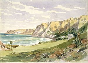
Gore Bay is a great place for surfing. It has many beach houses used in summer. About 14 people live there all year round. There are two local camping grounds. Both have easy access to the beach. Gore Bay is a popular spot for New Year's Eve celebrations.
A special natural feature here is Cathedral Gully. It is a stunning canyon made of weathered clay.
Port Robinson: A Historic Port
Port Robinson was once a busy port. Now, it is mostly abandoned. You can still see the old wharf. However, it is in a very unsafe condition.
Stonyhurst Station: A Historic Farm
Stonyhurst is a large farming station. It is located in the Blythe Valley, southwest of Cheviot. It was started in 1851 by Frederick Weld and Charles Clifford. They named it after Stonyhurst College in England, where they both went to school.
The farm was originally huge, covering almost 30,000 hectares. Over time, much of the land was sold off. The farm today is about one-tenth of its original size. The local government calls the area "a potentially significant natural area." The manager's cottage is also a protected historic building.
Learning in Cheviot: Schools and Education
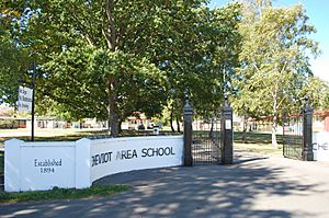
Schooling in Cheviot began in 1894. The first school was called McKenzie School. Its name changed to Cheviot School in 1931. At first, the school taught students up to Form Two (around Year 8). In 1937, it became Cheviot District High School.
Cheviot Area School is a combined school. It teaches students from Year 1 to Year 13. It also helps the community by offering ongoing education and facilities. The school had about 309 students as of 2024.
The large oak trees in the school grounds are special. They were planted to remember students who died in World War 2.
Cheviot Area School takes part in sports competitions. They compete with other schools in Canterbury. They also have international student exchanges with schools in Japan and Canada.
The town also has two preschools for younger children. These are Cheviot Learning Centre and The Tree Hut.
Cheviot's Weather
The average highest temperature in Cheviot from 2008 to 2024 was 34.8°C (94.6°F).
| Climate data for Cheviot (1991–2020 normals, extremes 1982–present) | |||||||||||||
|---|---|---|---|---|---|---|---|---|---|---|---|---|---|
| Month | Jan | Feb | Mar | Apr | May | Jun | Jul | Aug | Sep | Oct | Nov | Dec | Year |
| Record high °C (°F) | 37.9 (100.2) |
37.8 (100.0) |
35.4 (95.7) |
30.4 (86.7) |
28.2 (82.8) |
24.0 (75.2) |
22.6 (72.7) |
26.3 (79.3) |
25.2 (77.4) |
29.8 (85.6) |
33.1 (91.6) |
36.1 (97.0) |
37.9 (100.2) |
| Mean daily maximum °C (°F) | 23.3 (73.9) |
23.2 (73.8) |
21.0 (69.8) |
18.1 (64.6) |
15.5 (59.9) |
12.3 (54.1) |
12.2 (54.0) |
13.2 (55.8) |
15.0 (59.0) |
17.6 (63.7) |
19.1 (66.4) |
21.5 (70.7) |
17.7 (63.8) |
| Daily mean °C (°F) | 17.0 (62.6) |
16.7 (62.1) |
14.6 (58.3) |
11.7 (53.1) |
9.6 (49.3) |
6.7 (44.1) |
6.6 (43.9) |
7.5 (45.5) |
9.5 (49.1) |
11.5 (52.7) |
13.2 (55.8) |
15.4 (59.7) |
11.7 (53.0) |
| Mean daily minimum °C (°F) | 10.7 (51.3) |
10.2 (50.4) |
8.2 (46.8) |
5.4 (41.7) |
3.6 (38.5) |
1.2 (34.2) |
0.9 (33.6) |
1.8 (35.2) |
3.9 (39.0) |
5.5 (41.9) |
7.3 (45.1) |
9.3 (48.7) |
5.7 (42.2) |
| Record low °C (°F) | 0.0 (32.0) |
0.0 (32.0) |
−4.4 (24.1) |
−3.3 (26.1) |
−6.3 (20.7) |
−7.9 (17.8) |
−8.1 (17.4) |
−6.0 (21.2) |
−4.9 (23.2) |
−4.4 (24.1) |
−3.0 (26.6) |
−2.0 (28.4) |
−8.1 (17.4) |
| Average rainfall mm (inches) | 37.3 (1.47) |
52.7 (2.07) |
47.9 (1.89) |
66.4 (2.61) |
54.5 (2.15) |
82.8 (3.26) |
66.7 (2.63) |
62.0 (2.44) |
51.3 (2.02) |
70.3 (2.77) |
46.3 (1.82) |
45.0 (1.77) |
683.2 (26.9) |
| Mean monthly sunshine hours | 257.6 | 219.8 | 199.6 | 165.2 | 164.0 | 134.7 | 148.8 | 169.5 | 200.0 | 221.4 | 242.2 | 235.6 | 2,358.4 |
| Source: NIWA | |||||||||||||
 | Emma Amos |
 | Edward Mitchell Bannister |
 | Larry D. Alexander |
 | Ernie Barnes |


