
Waiau Uwha River facts for kids
Quick facts for kids Waiau Uwha |
|
|---|---|

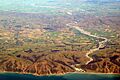
Waiau Uwha River upstream from the Waiau Ferry Bridge, near Hanmer Springs
|
|
.png)
Waiau River system
|
|
| Country | New Zealand |
| Region | Canterbury |
| District | Hurunui |
| City | Hanmer Springs, Waiau, Parnassus |
| Physical characteristics | |
| Main source | Southern Alps Spenser Mountains, New Zealand 42°6′39″S 172°38′42″E / 42.11083°S 172.64500°E |
| River mouth | Pacific Ocean New Zealand 0 m (0 ft) 42°46′40″S 173°22′19″E / 42.77778°S 173.37194°E |
| Basin features | |
| Basin size | 3,310 km2 (1,280 sq mi) |
| Tributaries |
|

The Waiau Uwha River is a big river in the northern part of Canterbury, located on the South Island of New Zealand. It used to be known simply as the Waiau River. This river starts high up in the Spenser Mountains and flows towards the east until it reaches the Pacific Ocean.
The Waiau Uwha River has the second largest catchment area in North Canterbury. A catchment area is all the land where water collects and flows into a specific river. For the Waiau Uwha, this area is about 3,310 square kilometers (1,278 square miles).
In 2018, the river's name was officially changed to Waiau Uwha River. This change was made to honor its original Māori name. It also helps people tell it apart from another, longer river called the Waiau River in the southern part of the South Island.
Contents
Exploring the Waiau Uwha River
The Waiau Uwha River is an important natural feature in New Zealand. It plays a big role in the local environment and for the communities living nearby.
Where Does the River Start?
The Waiau Uwha River begins its journey in the Southern Alps, specifically in the Spenser Mountains. These mountains are known for their rugged beauty and are a source for many rivers. The water comes from melting snow and rain high in the mountains.
The River's Journey to the Sea
From its mountain source, the river flows generally eastward. It travels through different landscapes before finally emptying into the Pacific Ocean. The point where a river meets the sea is called its mouth. For the Waiau Uwha, its mouth is at sea level.
Rivers Joining the Waiau Uwha
Many smaller rivers and streams flow into the Waiau Uwha River along its path. These are called tributaries. They add more water to the main river, making it larger.
On the left side of the river (if you're looking downstream), some of the tributaries include:
- Stanley River
- Edwards River
- Grantham River
- Percival River
- Hanmer River
- Mason River
- Stanton River
- Leader River
On the right side, you'll find:
- Ada River
- Henry River
- Hope River
These tributaries are like smaller branches of a tree, all connecting to the main trunk, which is the Waiau Uwha River.
Communities Along the River
Several towns and communities are located near the Waiau Uwha River. These places often rely on the river for various reasons, like water supply or recreation.
Towns and Districts
The river flows through the Hurunui District in the Canterbury Region. Some of the towns close to the river include:
- Hanmer Springs: A popular place known for its hot springs.
- Waiau: A small rural town.
- Parnassus: Another small settlement in the area.
These communities are connected to the river's health and its natural environment.
Why the Name Change?
The change from Waiau River to Waiau Uwha River in 2018 was very important. It was done to recognize the river's original Māori name.
Honoring Māori Heritage
Many places in New Zealand have Māori names that reflect their history and cultural importance. By officially changing the name, the government recognized the deep connection Māori people have with the land and its features. This helps preserve and respect the rich cultural heritage of New Zealand.
Avoiding Confusion
Another reason for the name change was to avoid confusion. There is another, longer river in the South Island also called the Waiau River, located in the Southland region. Adding "Uwha" to the North Canterbury river's name makes it clear which river is being talked about.
Images for kids
-

The Waiau Uwha River near the Waiau Ferry Bridge.
-
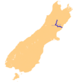
A map showing the Waiau Uwha River system in Canterbury.
-
The Waiau Uwha River in November 2015.
