Waiau, Canterbury facts for kids
Quick facts for kids
Waiau
|
|
|---|---|
|
town
|
|

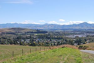
Waiau seen from the Leader Road. The Waiau Uwha River is in the background
|
|
| Country | New Zealand |
| Region | Canterbury |
| Territorial authority | Hurunui District |
| Ward | West Ward |
| Electorates |
|
| Area | |
| • Total | 0.97 km2 (0.37 sq mi) |
| Population
(June 2023)
|
|
| • Total | 270 |
| • Density | 278/km2 (721/sq mi) |
| Time zone | UTC+12 (New Zealand Standard Time) |
| • Summer (DST) | UTC+13 (New Zealand Daylight Time) |
| Postcode |
7332
|
Waiau is a small and friendly town in the northern part of Canterbury, located on the South Island of New Zealand. It's about 30 kilometers (19 miles) east of Hanmer Springs. The town sits on the northern side of the Waiau Uwha River, not far from where the river meets the sea. Waiau has useful shops like a small supermarket, a DIY store, and a petrol station for its residents and visitors.
Contents
Waiau's Past: A Look at its History
Waiau is the biggest town along State Highway 70. This road is also known as the Inland Kaikōura Route. For many years, from 1919 to 1978, Waiau was the end point of a special train line. This line, called the Waiau Branch, connected the town to the main railway network in Waipara.
There were plans to make this train line even longer, reaching all the way to Kaikōura. About 3 kilometers (1.9 miles) of the track was even started! However, the construction stopped. Instead, a different route along the coast was chosen for the main railway line.
At one time, Waiau had three different churches: a Presbyterian church, an Anglican church, and a Catholic church. The Catholic Parish of the Good Shepherd opened in 1900 and could seat 100 people.
The 2016 Kaikōura Earthquake
Waiau was greatly affected by the 2016 Kaikōura earthquake. The earthquake's center was very close, only 15 kilometers (9 miles) northeast of Culverden. This made it feel more like a "Waiau earthquake" for the town's residents.
Many buildings were damaged, including homes, the Waiau Lodge Hotel, and the historic cottage. The town's sports facilities like the bowling green, netball courts, and swimming pool were also hit. Even in 2021, you could still see signs of the earthquake's damage.
Waiau shares its name with a few other smaller places in New Zealand. The name "Waiau" comes from the Māori language and means "flowing water."
Who Lives in Waiau: Demographics
Statistics New Zealand describes Waiau as a rural settlement. It covers an area of 0.97 square kilometers (0.37 square miles). As of 2018, Waiau had an estimated population of 255 people. This means there were about 263 people living in each square kilometer. Waiau is part of a larger area called Amuri.
| Historical population | ||
|---|---|---|
| Year | Pop. | ±% p.a. |
| 2006 | 252 | — |
| 2013 | 258 | +0.34% |
| 2018 | 255 | −0.23% |
At the 2018 New Zealand census, Waiau had 255 residents. This was a small decrease of 3 people since the 2013 census. However, it was a small increase of 3 people since the 2006 census. There were 99 households in total.
The population included 126 males and 123 females. About 51 people (20%) were under 15 years old. There were 27 people (10.6%) aged 15 to 29. The largest group, 123 people (48.2%), were aged 30 to 64. Finally, 48 people (18.8%) were 65 or older.
Ethnic Backgrounds
Most people in Waiau, 88.2%, identified as European or Pākehā. About 21.2% identified as Māori. A smaller number, 2.4%, were Pasifika, and 1.2% were from other ethnic groups. It's important to remember that people can identify with more than one ethnic group.
Religious Beliefs
When asked about their religion, 67.1% of people said they had no religion. About 24.7% were Christian. A small number, 1.2%, followed Māori religious beliefs. Another 1.2% were Hindu, and 1.2% had other religions. Some people chose not to answer this question.
Education and Work
Of those aged 15 and older, 12 people (5.9%) had a university degree or higher. On the other hand, 75 people (36.8%) did not have any formal qualifications. About 15 people (7.4%) earned over $70,000 a year. This is lower than the national average of 17.2%.
When it came to jobs, 99 people (48.5%) worked full-time. Another 36 people (17.6%) worked part-time. Sadly, 9 people (4.4%) were unemployed.
Learning in Waiau: Education
Waiau School is a public primary school for students from Year 1 to Year 6. It teaches both boys and girls. As of July 2024, the school has about 32 students.
Fun in the Water: The Waiau Community Pool
The Waiau Community Pool was built in 2019. This new pool complex has a 25-meter swimming pool for laps and a smaller pool for toddlers. The old pool was sadly destroyed during the 2016 earthquake.
The Waiau Lodge Hotel: A Historic Building
The Waiau Lodge Hotel was a very old and important building in Waiau, built in 1910. It was once known as the "Grand Lady" and had ten bedrooms for guests. Frederick O'Malley was the first person to manage the hotel. He sold it in 1913 to Arthur Johnstone. Over the years, there were 21 different owners.
The hotel was badly damaged in the 2016 Kaikōura earthquake. All three of its chimneys fell through the roof, causing a lot of destruction. After the earthquake, a temporary pub called the Waiau Tavern was set up in the car park. It opened six months later so people in the town still had a place to gather. Sadly, in May 2021, the Waiau Lodge Hotel was completely destroyed by a fire. About thirty firefighters worked hard to put out the fire, which started late at night.
Waiau's Weather: Climate
The weather in Waiau can vary quite a bit. From 2008 to 2024, the highest temperature recorded was 34.8°C (94.6°F). The lowest temperature recorded during that time was -5.8°C (21.6°F).
| Climate data for Waiau (1991–2020 normals, extremes 1974–1989, 2008–present) | |||||||||||||
|---|---|---|---|---|---|---|---|---|---|---|---|---|---|
| Month | Jan | Feb | Mar | Apr | May | Jun | Jul | Aug | Sep | Oct | Nov | Dec | Year |
| Record high °C (°F) | 37.8 (100.0) |
36.5 (97.7) |
33.2 (91.8) |
29.3 (84.7) |
27.1 (80.8) |
23.8 (74.8) |
21.8 (71.2) |
24.0 (75.2) |
26.1 (79.0) |
30.3 (86.5) |
32.9 (91.2) |
34.7 (94.5) |
37.8 (100.0) |
| Mean daily maximum °C (°F) | 24.6 (76.3) |
24.4 (75.9) |
21.9 (71.4) |
18.7 (65.7) |
15.8 (60.4) |
12.1 (53.8) |
12.0 (53.6) |
13.8 (56.8) |
16.1 (61.0) |
18.3 (64.9) |
20.2 (68.4) |
22.9 (73.2) |
18.4 (65.1) |
| Daily mean °C (°F) | 18.1 (64.6) |
17.6 (63.7) |
15.1 (59.2) |
12.1 (53.8) |
9.4 (48.9) |
6.2 (43.2) |
6.0 (42.8) |
7.6 (45.7) |
10.0 (50.0) |
11.9 (53.4) |
14.0 (57.2) |
16.5 (61.7) |
12.0 (53.7) |
| Mean daily minimum °C (°F) | 11.6 (52.9) |
10.8 (51.4) |
8.4 (47.1) |
5.4 (41.7) |
3.1 (37.6) |
0.3 (32.5) |
0.0 (32.0) |
1.4 (34.5) |
4.0 (39.2) |
5.5 (41.9) |
7.7 (45.9) |
10.1 (50.2) |
5.7 (42.2) |
| Record low °C (°F) | 0.6 (33.1) |
0.0 (32.0) |
−0.9 (30.4) |
−4.0 (24.8) |
−7.4 (18.7) |
−8.8 (16.2) |
−7.9 (17.8) |
−6.6 (20.1) |
−4.4 (24.1) |
−3.5 (25.7) |
−1.5 (29.3) |
−2.5 (27.5) |
−8.8 (16.2) |
| Average rainfall mm (inches) | 58.8 (2.31) |
51.2 (2.02) |
65.5 (2.58) |
57.5 (2.26) |
62.1 (2.44) |
81.1 (3.19) |
74.7 (2.94) |
68.7 (2.70) |
59.8 (2.35) |
68.9 (2.71) |
66.7 (2.63) |
57.7 (2.27) |
772.7 (30.4) |
| Source: NIWA | |||||||||||||
 | Selma Burke |
 | Pauline Powell Burns |
 | Frederick J. Brown |
 | Robert Blackburn |


