Lake Sumner facts for kids
Quick facts for kids Hoka Kura (Lake Sumner) |
|
|---|---|

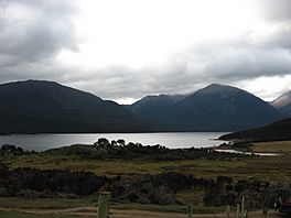
Hoka Kura (Lake Sumner), viewed from above Shoal Bay
|
|
| Location | Lake Sumner Forest Park, Hurunui District in the Canterbury region, South Island |
| Coordinates | 42°42′00″S 172°13′01″E / 42.70°S 172.217°E |
| Basin countries | New Zealand |
| Surface area | 1,373 ha (3,390 acres) |
| Average depth | 135 m (443 ft) |
| Surface elevation | 505 m (1,657 ft) |
Hoka Kura, also known as Lake Sumner, is a beautiful lake in the South Island of New Zealand. Its Māori name, Hoka Kura, is very important. This lake is found in the Canterbury Region, about 100 km (62 mi) northwest of the city of Christchurch.
Hoka Kura is quite large, covering an area of about 1,373 ha (3,390 acres) (that's like 1,373 rugby fields!). It's also very deep, reaching down to 135 m (443 ft) in some places. The lake is a big part of the Lake Sumner Forest Park and is connected to the Hurunui River. Inside this park, you can find other cool lakes like Loch Katrine, Lake Sheppard, Lake Taylor, and Lake Mason.
Contents
Exploring Hoka Kura
The area around Hoka Kura is a fantastic place for outdoor adventures. Because it's a bit remote, it doesn't get too crowded, which is great for enjoying nature.
Fun Activities
Many people visit Hoka Kura for exciting activities:
- Hunting: Some parts of the park allow hunting.
- Tramping: This is like hiking, and there are many trails to explore.
- Fishing: The lake is known for its trout fishing.
- Whitewater Kayaking: If you love water sports, the rivers here are perfect for kayaking.
- Mountain Biking: You can also ride your bike on special trails.
Staying Overnight
The Department of Conservation has built several tramping huts in the region. These huts are simple shelters where people can stay overnight during their trips. They make it easier to explore the area for more than one day.
How Hoka Kura Was Formed
Hoka Kura is a cold, clear lake that formed a very long time ago, about 18,000 years ago! It's an oligotrophic lake, which means it has very few nutrients. This is why its water is so clear.
Glacial Origins
The lake sits in a long, deep valley that was carved out by huge sheets of ice called glaciers. This happened during the last Ice Age. The valley is about 9.7 km (6.0 mi) long and 2.4 km (1.5 mi) wide.
Water Flow
The North Branch of the upper Hurunui River flows into Hoka Kura at its northwestern end. It brings in small stones and gravel, forming a delta. The water then flows out of the lake through a narrow natural passage at the southeastern end, continuing its journey down the Hurunui River.
 | Frances Mary Albrier |
 | Whitney Young |
 | Muhammad Ali |


