Hurunui River facts for kids
Quick facts for kids Hurunui River |
|
|---|---|

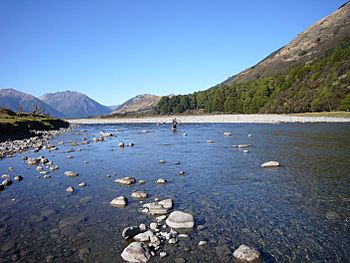
A mountainbiker crossing the Hurunui River upstream of Lake Sumner
|
|
| Lua error in Module:Location_map at line 420: attempt to index field 'wikibase' (a nil value).
Location of the mouth within New Zealand
|
|
| Country | New Zealand |
| Physical characteristics | |
| Main source | Southern Alps |
| River mouth | Pacific Ocean sea level |
| Basin features | |
| Basin size | 2,670 km (1,660 mi) |
The Hurunui River is a large river in the north of Canterbury, New Zealand. It's one of the four main rivers in this area. The river starts high up in the Southern Alps and flows all the way to the Pacific Ocean. Its water collects from a huge area of about 2,670 square kilometers (1,030 square miles).
| Top - 0-9 A B C D E F G H I J K L M N O P Q R S T U V W X Y Z |
Where is the Hurunui River?
The Hurunui River begins at a place called Harper Pass. On the other side of this pass, you'll find another river, the Taramakau River. The Hurunui River has several smaller rivers that flow into it, like the Jollie Brook, the Hurunui River South Branch, the Glenrae River, and the Mandamus River. The river also flows through a beautiful lake called Lake Sumner. There's even a cool hot pool built next to a small waterfall on one of the river's side streams.
Fun Activities on the River
The Hurunui River is a great spot for adventure! It has exciting rapids that are rated as Class II and Class III on the international scale for river difficulty. This makes it a very popular place for kayaking. The most thrilling parts for whitewater kayaking are in Maori Gully and Harwarden Gorge, especially where the north and south branches of the river join together.
You can also go fishing here! In the 1900s, a type of fish called Chinook salmon (Oncorhynchus tshawytscha) was brought here from California. They were introduced for people who enjoy game fishing.
Protecting the River's Water
People in New Zealand care a lot about their rivers. In 2007, two groups, the New Zealand Fish and Game Council and the New Zealand Recreational Canoeing Association (now called Whitewater NZ), asked the Ministry for the Environment to create a special rule called a Water Conservation Order for the Hurunui River. This order helps protect the river's natural state.
In 2009, a special group looked at the request. They suggested that the North Branch of the Hurunui River should get this protection, but not the South Branch. However, Whitewater NZ disagreed and asked the Environment Court to include the South Branch too, because they believed it also needed protection.
Plans for the Hurunui River
There's a big plan called the Hurunui Water Project. This project wants to build dams and take water from the river for irrigation, which means supplying water to farms. They asked Environment Canterbury, the local council in charge of the river, for permission.
The plan involves:
- Making Lake Sumner higher with a weir (a small dam).
- Building a dam and a new lake on the south branch of the river.
- Taking water from the main part of the river.
In October 2009, the Hurunui Water Project decided to pause their plans for about a year. They wanted to wait for a bigger plan called the Canterbury Water Management Strategy to figure out how to best store water in the region.
Even though the project was paused, many people still protested. A march happened in Christchurch to show how much people cared about the river. Hundreds of people marched, and kayakers and fishers even traveled down the Avon River to join in. An artist named Sam Mahon, who was worried about water pollution, even made a sculpture of a politician named Nick Smith out of cow dung to draw attention to the campaign against damming the Hurunui River.
In February 2010, the Hurunui Water Project announced they would start their application process again. They even went to the High Court in November 2010 because they disagreed with Environment Canterbury's decision to make damming the Hurunui River a "non-complying activity" in the regional plan.
In September 2012, the public was asked for their thoughts on the project again. The updated plan included building four dams on the Waitohi River and taking large amounts of water from both the Hurunui and Waitohi rivers. They also planned to generate electricity from the river's flow and store a lot of water in other dams. To give you an idea, the Hurunui River's average flow is about 53 cubic meters per second, and its low flow is about 16.8 cubic meters per second. The project wanted to take up to 49.2 cubic meters per second from the main Hurunui River and 42.4 cubic meters per second from the Waitohi River.
 | John T. Biggers |
 | Thomas Blackshear |
 | Mark Bradford |
 | Beverly Buchanan |

