
Zealandia facts for kids

Zealandia, also known as the New Zealand continent, is a huge piece of land that is mostly underwater. It used to be part of a supercontinent called Gondwana. Zealandia broke away from Antarctica a very long time ago, between 85 and 130 million years ago. Later, it separated from Australia about 60 to 85 million years ago.
Most of Zealandia (about 93%) is now hidden beneath the Pacific Ocean. It might have been completely underwater around 23 million years ago. Zealandia covers a massive area of about 4.92 million square kilometers (1.9 million square miles). This makes it the largest "microcontinent" in the world. It's more than twice the size of the next biggest microcontinent and over half the size of the Australian continent!
Because of its huge size and other features like its crust thickness, many scientists now believe Zealandia should be called a continent on its own. In 2017, a group of geologists from New Zealand, New Caledonia, and Australia agreed that Zealandia meets all the requirements to be a continent. One geologist, Nick Mortimer, said that if it wasn't for the ocean covering it, Zealandia would have been recognized as a continent a long time ago.
Even though it's mostly underwater, Zealandia is important for fishing. It also has natural gas fields, like New Zealand's Maui gas field. There are also other valuable resources hidden offshore, such as iron sands and mineral deposits.
Contents
Exploring Zealandia's Geology


Zealandia is mostly made up of two long, parallel ridges. These ridges are separated by a "failed rift," which is like a giant crack in the Earth that started to split but then stopped. The ridges rise about 1,000 to 1,500 meters (3,300 to 4,900 feet) above the ocean floor. Only a few rocky islands poke out above the sea level.
These ridges are made of continental rock, but they are lower than normal continents. This is because their crust (the Earth's outer layer) is thinner than usual, only about 20 kilometers (12 miles) thick. Because it's thinner, it doesn't float as high on the Earth's mantle (the layer below the crust).
About 25 million years ago, the southern part of Zealandia started to move differently from the northern part. This movement happened along a major crack called the Alpine Fault in New Zealand. This shift caused parts of the land to move about 500 kilometers (310 miles) apart. The movement also pushed up the Southern Alps in New Zealand. Even though these mountains are very tall, their height is only a small part of how much they were actually pushed up, because erosion wears them down quickly.
Further north, the movement of the Pacific Plate under the Indo-Australian Plate has caused a lot of volcanic activity. This created areas like the Coromandel and Taupo Volcanic Zones.
Volcanoes have erupted across Zealandia many times, even before it broke away from the supercontinent Gondwana. Although Zealandia has moved about 6,000 kilometers (3,700 miles) northwest since it separated from Antarctica, the magma (melted rock) from its volcanoes is similar to that found in nearby parts of Antarctica and Australia. Most of these eruptions were small, except for huge shield volcanoes that formed the Banks and Otago Peninsulas during the Miocene period. Scientists are still trying to understand why these volcanoes kept erupting.
Scientists sometimes divide Zealandia into two main areas: North Zealandia and South Zealandia. These two parts are separated by the Alpine Fault and the Kermadec Trench. They are also moving separately from each other.
Why Zealandia is a Continent
The idea that Zealandia is its own continent was strongly supported by scientists Nick Mortimer and Hamish Campbell in their 2014 book, Zealandia: Our continent revealed. They used evidence from geology and living things to make their case.
In 2017, a group of eleven geologists from New Zealand, New Caledonia, and Australia officially agreed. They concluded that Zealandia meets all the requirements to be called a drowned continent, not just a small piece of land. This news was shared widely around the world.
Life on Zealandia
New Caledonia is at the northern end of this ancient continent, and New Zealand is where the land rises at the plate boundary. These land areas are home to plants that are part of the Antarctic Flora, including Araucaria trees and Podocarp trees.
At Curio Bay in New Zealand, you can see logs of a fossilized forest. These trees, similar to modern Kauri and Norfolk pines, grew on Zealandia about 180 million years ago. This was during the Jurassic period, before Zealandia split from Gondwana. Volcanic mud flows buried these trees, and over time, they turned into fossils made of silica.
During very cold periods (ice ages), more of Zealandia becomes dry land instead of being covered by the sea. For a long time, people thought Zealandia had no native land mammals. However, in 2006, scientists found a fossil of a mammal jaw from the Miocene period in the Otago region. This discovery showed that mammals did live on Zealandia in the past!
Countries and Territories of Zealandia

The total land area of Zealandia (including inland water bodies) is about 286,655 square kilometers (110,678 square miles). Most of this land belongs to New Zealand.
- New Zealand makes up the largest part, with about 267,988 square kilometers (103,471 square miles). This includes the main islands and many smaller islands like the Antipodes Islands, Auckland Islands, Bounty Islands, Campbell Islands, and Chatham Islands.
- New Caledonia and its surrounding islands cover about 18,576 square kilometers (7,172 square miles).
- The rest of Zealandia's land belongs to Australia. This includes the Lord Howe Island Group (about 56 square kilometers or 22 square miles), Norfolk Island (about 35 square kilometers or 14 square miles), and the tiny Elizabeth and Middleton Reefs (about 0.25 square kilometers or 0.1 square miles).
People of Zealandia
Today, about 5 million people live on the parts of Zealandia that are above water.
- New Zealand – about 4.8 million people
- New Caledonia – about 268,000 people
- Norfolk Island – about 2,200 people
- Lord Howe Island Group – about 380 people
- Elizabeth and Middleton Reefs – 0 people
Images for kids
-
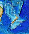
Topography of Zealandia. The linear ridges running north-northeast (Colville to the west and Kermadec to the east, separated by the Havre Trough and Lau Basin) and southwest (the Resolution Ridge System) away from New Zealand are not considered part of the continental fragment, nor are Australia (upper left), Fiji or Vanuatu (top centre).
-
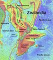
Topographic map of Zealandia
-
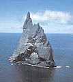
Most of Zealandia is underwater. Ball's Pyramid, near Lord Howe Island, is one place where it rises above sea level
-
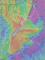
Exclusive economic zone of New Zealand and continental shelf boundaries for much of Zealandia
See also
 In Spanish: Zelandia (continente) para niños
