
Ball's Pyramid facts for kids
Quick facts for kids Ball's Pyramid |
|
|---|---|

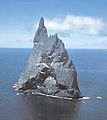
Ball's Pyramid viewed from the north
|
|
| Highest point | |
| Elevation | 562 m (1,844 ft) |
| Geography | |

Ball's Pyramid
Location in Oceania
|
|
| Location | Lord Howe Island Group, Australia |
| Parent range | Lord Howe Island Group |
| Geology | |
| Age of rock | < 7 million years |
| Mountain type | Volcanic plug |
| Volcanic arc/belt | Lord Howe Seamount Chain |
| Last eruption | Unknown |
| Climbing | |
| First ascent | 1965 |
Ball's Pyramid is a tall, narrow rock that stands alone in the Pacific Ocean. It's like a giant, pointy island. This amazing rock is what's left of an old shield volcano and its caldera (a large volcanic crater). It sits about 20 kilometers (12 miles) southeast of Lord Howe Island.
Ball's Pyramid is 562 meters (1,844 feet) high. It's only about 1,100 meters (3,600 feet) long and 300 meters (980 feet) wide. This makes it the tallest volcanic rock tower, or stack, in the world! It's part of the Lord Howe Island Marine Park in Australia. It lies over 643 kilometers (400 miles) northeast of Sydney, New South Wales.
This steep, eroded rock formed about 6.4 million years ago. It stands in the middle of a flat area under the sea. The waters around it are often rough, making it hard to get close.
Contents
Discovering Ball's Pyramid

This unique pyramid-shaped rock is named after Royal Navy Lieutenant Henry Lidgbird Ball. He was the first European to report seeing it in 1788. On the same trip, Lieutenant Ball also discovered Lord Howe Island.
In a book from 1789, Governor Arthur Phillip described the area. He mentioned a dangerous rock near the pyramid. It was just above the water and looked small, like a boat. Lieutenant Ball didn't get to check if it was safe to sail between them.
Exploring the Pyramid
The first person known to land on Ball's Pyramid was Henry Wilkinson. He was a geologist from New South Wales. This happened in 1882.
In 1964, a group from Sydney tried to climb the pyramid. This team included adventurer Dick Smith. They had to turn back on the fifth day. They ran out of food and water.
Ball's Pyramid was first successfully climbed on February 14, 1965. The climbers were Bryden Allen, John Davis, Jack Pettigrew, and David Witham. They were from the Sydney Rock Climbing Club. The next day, Jack Hill from New Zealand also reached the top with Jack Pettigrew.
In 1979, Dick Smith returned with climbers John Worrall and Hugh Ward. They made it to the summit! They raised a flag of New South Wales there. This officially declared the island Australian territory.
Climbing Ball's Pyramid was banned in 1982. Then, in 1986, all access to the island was stopped. In 1990, the rules became a bit easier. Some climbing was allowed under very strict conditions. Today, you need special permission from a government minister to climb it.
Where is Ball's Pyramid?
Ball's Pyramid is located on the Lord Howe Rise. This is a large underwater area that is part of Zealandia. Zealandia is a mostly submerged continent.
Ball's Pyramid has a few smaller rocks nearby. Observatory Rock and Wheatsheaf Islet are about 800 meters (2,600 feet) to its west. Southeast Rock is a tall, pointed rock about 3.5 kilometers (2.2 miles) southeast of the pyramid.
The underwater shelf around the pyramid is 20 kilometers (12 miles) long. It's about 10 kilometers (6.2 miles) wide. The water above it is usually about 50 meters (160 feet) deep. A deep underwater valley, about 500 meters (1,600 feet) deep, separates this shelf from another one. Lord Howe Island sits on that other shelf. The steep sides of Ball's Pyramid continue deep under the water.
Plants and Animals
Ball's Pyramid is home to some unique living things.
The Tea Tree Bush
A type of tea tree bush, called Melaleuca howeana, was found growing on Ball's Pyramid. This bush was in a small crack in the rocks. Water seeped through the cracks, helping the plant grow. Over time, this created a deep layer of plant material.
The Lord Howe Island Stick Insect
Ball's Pyramid is the only place in the wild where the Lord Howe Island stick insect (Dryococelus australis) still lives.
People thought this insect was extinct after 1920. That's when it was last seen on Lord Howe Island. But in 1964, during a climb, a dead stick insect was found on Ball's Pyramid. This gave hope that they were still alive! More dead ones were found later, but no live ones.
In 2001, a team of scientists and conservationists visited Ball's Pyramid. They hoped to find the insects. And they did! They found a small group of them living under a single Melaleuca howeana bush. It was about 100 meters (330 feet) above the shoreline. There were only 24 insects. Two pairs were taken to mainland Australia. New populations have been successfully bred there. The goal is to bring them back to Lord Howe Island someday.
In 2014, climbers saw live stick insects in another spot. They were 65 meters (213 feet) below the summit. This showed that the insects live in more places on the pyramid than thought. It also showed they eat more than just the tea tree bush.
Images for kids
-
Aerial view

See also
 In Spanish: Pirámide de Ball para niños
