
Lord Howe Island facts for kids

Satellite image of the island; north is toward the upper right corner
|
|
 |
|
| Geography | |
|---|---|
| Location | Lord Howe Island, Tasman Sea |
| Coordinates | 31°33′15″S 159°05′06″E / 31.55417°S 159.08500°E |
| Total islands | 28 |
| Major islands | Lord Howe Island, Admiralty Group, Mutton Bird Islands, and Ball's Pyramid |
| Area | 14.55 km2 (5.62 sq mi) |
| Highest elevation | 875 m (2,871 ft) |
| Highest point | Mount Gower |
| Administration | |
| Administrative Division | Unincorporated area of New South Wales Self-governed by the Lord Howe Island Board Part of the electoral district of Port Macquarie Part of the Division of Sydney |
| Demographics | |
| Population |
|
| Pop. density | 26.25 /km2 (67.99 /sq mi) |
| Additional information | |
| Time zone |
|
| • Summer (DST) |
|
| Postcode | 2898 |
| Official name | Lord Howe Island Group |
| Type | Natural |
| Criteria | vii, x |
| Designated | 1982 (6th session) |
| Reference no. | 186 |
| Region | Asia-Pacific |
| Official name | Lord Howe Island Group, Lord Howe Island, NSW, Australia |
| Type | Natural |
| Designated | 21 May 2007 |
| Reference no. | 105694 |
| File number | 1/00/373/0001 |
| Official name | Lord Howe Island Group |
| Type | State heritage (landscape) |
| Designated | 2 April 1999 |
| Reference no. | 970 |
| Type | Other – Landscape – Cultural |
| Category | Landscape – Cultural |
Lord Howe Island is a beautiful, crescent-shaped island formed by volcanoes. It sits in the Tasman Sea, between Australia and New Zealand. This special island is part of the Australian state of New South Wales.
It is about 600 kilometers (370 miles) east of Port Macquarie on the mainland. Sydney is about 780 kilometers (485 miles) to the southwest. The island is about 10 kilometers (6 miles) long and 0.3 to 2.0 kilometers (0.2 to 1.2 miles) wide. Its total area is 14.55 square kilometers (5.6 square miles).
Along the west coast, you will find a sandy lagoon protected by a coral reef. Most people live in the northern part of the island. The southern part has forested hills, with Mount Gower being the highest point at 875 meters (2,871 feet). The Lord Howe Island Group includes 28 islands, islets, and rocks. The most famous one, besides Lord Howe Island itself, is Ball's Pyramid. This volcanic rock is about 23 kilometers (14 miles) southeast and is not inhabited. To the north, there is a group of seven small, uninhabited islands called the Admiralty Group.
Europeans first saw Lord Howe Island on February 17, 1788. Lieutenant Henry Lidgbird Ball was sailing from Botany Bay to Norfolk Island. On his way back, he sent a group ashore to claim the island for Britain. Later, it became a stop for whaling ships to get supplies. People started living there permanently in June 1834. When whaling became less popular, the island began exporting its unique kentia palms in the 1880s. This is still a big part of the island's economy. Tourism also started after World War II in 1945.
The Lord Howe Island Group is part of New South Wales. It is managed by the Lord Howe Island Board, which reports to the New South Wales Minister for Environment and Heritage. The island's time zone is UTC+10:30, or UTC+11 during daylight saving time. The currency used is the Australian dollar. Small planes fly to Sydney, Brisbane, and Port Macquarie.
UNESCO has listed the Lord Howe Island Group as a World Heritage Site. This means it is very important for its natural beauty and unique features. Most of the island is untouched forest, with many plants and animals found nowhere else. It also has a special coral reef, which is the southernmost in the world. The island was added to the Australian National Heritage List in 2007 and the New South Wales State Heritage Register in 1999. The waters around the island are also protected as the Lord Howe Island Marine Park.
Contents
- Exploring Lord Howe Island's Natural Environment
- Island History: A Timeline of Discovery and Settlement
- Who Lives on Lord Howe Island?
- How Lord Howe Island is Governed
- Island Economy: How People Make a Living
- Geography of Lord Howe Island
- Plants and Animals of Lord Howe Island
- ===Images for kids
- Heritage Status
- Sports on the Island
- See also
Exploring Lord Howe Island's Natural Environment
Lord Howe Island is a special place for nature. It is part of the 'Pacific Subtropical Islands' region. In the world's ecoregion system, it is known as the 'Lord Howe Island subtropical forests'. This means it has a warm, wet climate with lots of trees.
Island History: A Timeline of Discovery and Settlement
First European Visits: 1788–1834

Before Europeans arrived, Lord Howe Island was empty. No people lived there, and it was unknown to the Polynesian people of the South Pacific. The first time Europeans saw the island was on February 17, 1788. Lieutenant Henry Lidgbird Ball was in charge of the ship HMS Supply. He was sailing from Botany Bay to set up a prison colony on Norfolk Island.
On his way back, on March 13, 1788, Ball saw Ball's Pyramid. He sent a group to Lord Howe Island to claim it for Britain. They caught many turtles and tame birds to take back to Sydney. Ball named Mount Lidgbird and Ball's Pyramid after himself. He named the main island after Richard Howe, 1st Earl Howe, who was a top navy official.

Many island names come from this time. In May 1788, four more ships from the First Fleet visited. People on these ships wrote about the plants and animals they saw. Artists like George Raper and John Hunter drew pictures of native birds. These included the Lord Howe woodhen, white gallinule, and Lord Howe pigeon. Sadly, the white gallinule and Lord Howe pigeon were soon hunted to extinction. These paintings are the only pictures we have of them.
For the next three years, the Supply returned to the island for turtles. Other ships also visited. In the late 1700s, the whaling industry started. Lord Howe Island was in a good spot for whaling ships. Some ships left goats and pigs on the island for future food. Whale oil became Australia's most valuable export until the 1830s. The whaling industry played a big role in Lord Howe Island's early history.
Permanent Settlement: 1834–1841

People started living on Lord Howe Island permanently in June 1834. The British whaling ship Caroline arrived from New Zealand. It left three men: George Ashdown, James Bishop, and Chapman. They were hired by a Sydney whaling company to set up a supply station. Their job was to provide meat by fishing and raising pigs and goats. They also brought their Māori wives and two Māori boys.
They built huts in an area now called Old Settlement, where there was fresh water. They also started a garden. This was a cashless society. The settlers traded water, wood, vegetables, meat, fish, and bird feathers. In return, they got clothes, tea, sugar, tools, and tobacco from visiting ships. The whalers decided the value of these goods. These first settlers eventually left the island in September 1841. They sold their business for £350 to Owen Poole and Richard Dawson. Their employees then settled on the island.
Trading and Growth: 1842–1860
The new business advertised, and ships traveling between Sydney and Vanuatu began to stop at the island. The Rover's Bride was the first regular trading ship. Between 1839 and 1859, many ships visited each year. In 1842 and 1844, the first children were born on the island. In 1847, Poole, Dawson, and Foulis left the island. But three of their workers stayed.
One family, the Andrews, found onions on the beach in 1848. They grew them into the "Lord Howe red onion." This onion was popular for about 30 years until a plant disease attacked the crop.

By 1849, only 11 people lived on the island. But soon, the island farms grew. In the 1850s, gold was found in mainland Australia. Many ship crews left their ships to dig for gold. Because of this, many ships avoided the mainland and traded more with Lord Howe Island. Trade was busiest between 1855 and 1857. By 1851, about 16 people lived on the island. They grew potatoes, carrots, corn, pumpkin, and even grapes.
From 1851 to 1854, Captain Henry Denham of HMS Herald mapped the island. His ship was on a scientific trip to the southwest Pacific. Three Scottish biologists were on board. They collected fish and plant samples. These scientists gathered important information about the island's geology, plants, and animals.
Around 1853, Nathan Thompson arrived with three women from the Gilbert Islands. Thompson was the first resident to build a strong house in the 1860s. Most island residents with old family ties are related to Thompson and his second wife, Bogue. In 1855, the island officially became part of New South Wales.
Scientific Expeditions and Palm Trade: 1861–1890
Whaling quickly declined in the early 1860s. This was due to the rise of petroleum and the American Civil War. To find new ways to make money, Nathan Thompson bought a ship called the Sylph in 1867. It was the first local ship to trade with Sydney, mainly selling pigs and onions. Sadly, the Sylph was lost at sea in 1873.
In 1869, a magistrate named P. Cloete visited the island. He was with Charles Moore, director of the Botanic Gardens in Sydney. They collected plant samples. A surveyor named William Fitzgerald also mapped the island. Their findings were published in 1870. The population was 35 people, living in 13 houses made of palm wood and leaves. Trade slowed down, and sometimes no ships visited for months.
In 1876, a government report suggested growing coffee. But the kentia palm was already becoming famous worldwide. In 1878, the island was made a Forest Reserve. Captain Richard Armstrong became the first government administrator. He encouraged schools, tree planting, and the palm trade. He also used dynamite to open the north passage to the lagoon and built roads.
A team of scientists visited in 1882. They took the earliest known photos of the island. Their report suggested replacing Armstrong. It also recommended appointing a schoolmaster, as the population had grown to include 29 children. This visit started a lasting connection with three scientific groups: the Australian Museum, Sydney Royal Botanic Gardens, and Kew Royal Botanic Gardens.
Modern Era: 1890–Present
In 1883, the company Burns Philp started regular shipping services. This led to a gradual increase in tourists. By 1932, tourism became the second largest source of income after palm sales. Today, the Island Trader ship delivers supplies every two weeks from Port Macquarie.
The palm trade began in the 1880s. The lowland kentia palm (Howea forsteriana) was exported to Britain, Europe, and America. In 1906, the Lord Howe Island Kentia Palm Nursery was formed, making the business more stable.
The first plane landed on the island in 1931. It was a de Havilland Gipsy Moth floatplane flown by Francis Chichester. After World War II, in 1947, tourists arrived on flying boats. These planes landed on the lagoon. When Lord Howe Island Airport was finished in 1974, regular planes replaced the flying boats.
In 2002, the Royal Navy ship HMS Nottingham hit a reef near Lord Howe Island and almost sank. Tourism has grown, and the New South Wales government is now more involved in protecting the island. In 2011, a supply ship ran aground in the lagoon but was refloated safely. The 2016 film The Shallows was filmed on the island.
One big issue for islanders today is how to deal with rodents. Rats arrived on the island in 1918 and have caused several native bird species to disappear. There is a plan to drop rat bait across the island, but people have different opinions about it.
Who Lives on Lord Howe Island?
In 2016, 382 people lived on Lord Howe Island. The number of tourists is limited to 400 at any time. The first settlers were European and American whalers. Many of their descendants still live on the island today. Residents work in the kentia palm industry, tourism, retail, fishing, and farming.
The island has Anglican, Roman Catholic, and Adventist churches. About 30% of the population is Anglican, 22% have no religion, 18% are Catholic, and 12% are Seventh Day Adventist. Most residents are between 25 and 54 years old, and 92% are Australian citizens.
How Lord Howe Island is Governed
The British Crown first controlled Lord Howe Island. Then, in 1855, it became part of New South Wales. For a while, the islanders managed themselves. In 1878, Richard Armstrong was made administrator. But he caused problems, and was removed in 1882. After him, magistrates managed the island until 1913.
In 1913, the Lord Howe Island Board of Control was set up in Sydney. Its main job was to manage the palm seed industry. In 1954, the current Lord Howe Island Board was created. This board is an official NSW government body. It manages the island as part of New South Wales. The board protects the island's World Heritage values. It also controls building, manages Crown Land, and provides community services.
In 1981, a law change gave islanders more power. Three of the five board members were elected from the island. Now, the board has seven members. Four are elected by the island community, giving residents a lot of say in how the island is run. The other three members are chosen by the minister to represent business, tourism, and conservation. The board also runs the kentia palm nursery, which, along with tourism, is the island's main source of income.
Land ownership has been an issue since the first settlers arrived. They wanted to own the land they farmed. In 1953, a law made all land property of the Crown. However, descendants of early settlers were given special leases for their homes. There is still discussion about land rights and how islanders influence long-term plans for visitors and the environment.
Island Economy: How People Make a Living
The Kentia Palm Business
The first person to export palm seeds was Ned King. He sent seeds to the Sydney Botanic Gardens. In the 1880s, the kentia palm (Howea forsteriana) became popular worldwide. It grew well in the fancy conservatories of wealthy people in Britain, Europe, and America. The Lord Howe Island Kentia Palm Nursery was started in 1906. This made the business financially strong.
The kentia palm is also known as the thatch palm. Early settlers used its leaves to roof their houses. It is popular as a decorative plant because it can grow well indoors. It tolerates low light, dry air, and cooler temperatures. This makes it perfect for hotels and large lobbies. Its high price is due to its rarity.
Until the 1980s, only palm seeds were sold. Now, only high-quality seedlings are exported. The nursery has special certification for its good management. Seeds are collected from natural forests and plantations. Collectors are often descendants of the original settlers. The seeds are grown in special soil-free material to prevent contamination. After testing, seedlings are cleaned, sanitized, and packed for export. The money from the nursery helps fund projects that improve the island's natural environment. The nursery plans to grow other native plants, like the curly palm. By the late 1980s, palm exports brought in over A$2 million each year. This was the island's main industry, besides tourism.
Tourism on Lord Howe Island

Lord Howe Island is famous for its unique geology, birds, plants, and marine life. Popular activities for tourists include scuba diving, birdwatching, snorkelling, surfing, kayaking, and fishing. To protect the island's small environment, only 400 tourists are allowed at any one time. You can reach the island by plane from Sydney Airport or Brisbane Airport in less than two hours. The Permanent Park Preserve, created in 1981, is managed like a national park.

Tourist Facilities
With fewer than 800 people on the island at any time, there are not many facilities. You can find a bakery, butcher, general store, and liquor store. There are also restaurants, a post office, a museum, and an information center. The island has a police officer, a park ranger, and an ATM at the bowling club. Supplies arrive every two weeks by the Island Trader ship from Port Macquarie.
The island has a small four-bed hospital. Electricity is 240 volts AC, generated by diesel, but also supported by solar power and batteries. There is no public transport or mobile phone service. However, public telephones, fax, and internet access are available. The island also has a local radio station and a newsletter called The Signal.
Tourist places range from fancy lodges to apartments. The currency is the Australian dollar. There are no camping sites on the island. To protect the fragile environment of Ball's Pyramid, climbing there is not allowed. You cannot bring pets without permission from the board. Islanders use rainwater, with extra water from bores for washing.
Fun Activities on the Island


Since places are close, cycling is the main way to get around. Tourists can play golf (9-hole), lawn bowls, and tennis. Other activities include fishing, yachting, windsurfing, kitesurfing, and kayaking. Boat trips, including glass-bottom tours of the lagoon, are also popular.
Swimming, snorkelling, and scuba diving are popular in the lagoon. You can also dive off Tenth of June Island, where the seafloor drops 36 meters (118 feet). Other diving spots are near Ball's Pyramid, 26 kilometers (16 miles) away.
You can go bushwalking and take nature tours. The most challenging hike is an eight-hour guided trip to the top of Mount Gower. The island has 11 beaches. A popular activity is hand-feeding the 1-meter (3.3 feet) long kingfish and large wrasse at Ned's Beach. Walking tracks cover the island, with different difficulty levels. Some popular tracks include Transit Hill, North Bay, and Mount Eliza.
Geography of Lord Howe Island


Lord Howe Island is a volcanic island shaped like a crescent. It is in the southwest Pacific Ocean, in the Tasman Sea. The island is 600 kilometers (370 miles) east of mainland Port Macquarie. It is about 10 kilometers (6 miles) long and 0.3 to 2.0 kilometers (0.2 to 1.2 miles) wide. Its area is 14.55 square kilometers (5.6 square miles).
Along the west coast, there is a protected coral reef lagoon with white sand. This is the easiest of the island's eleven beaches to reach. Both the north and south parts of the island have high ground with untouched forests. In the south, there are two volcanic mountains: Mount Lidgbird (777 meters or 2,549 feet) and Mount Gower (875 meters or 2,871 feet). Mount Gower is the highest point on the island. These two mountains are separated by a low area called the saddle. In the north, where most people live, high points include Malabar (209 meters or 686 feet) and Mount Eliza (147 meters or 482 feet). Between these high areas is a cleared lowland with some farms, the airport, and houses.
The Lord Howe Island Group has 28 islands, islets, and rocks. The most famous one, besides Lord Howe Island, is Ball's Pyramid. This pointed, rocky island is an eroded volcano about 23 kilometers (14 miles) to the southeast. It is 551 meters (1,808 feet) high and is not inhabited by people. However, it is home to the only known wild population of the Lord Howe Island stick insect, which was once thought to be extinct. To the north, there is the Admiralty Group, a cluster of seven small, uninhabited islands.
How the Island Was Formed

Lord Howe Island is what is left of a 7-million-year-old shield volcano. It was formed by eruptions that lasted about 500,000 years. It is part of a chain of islands on the western edge of an undersea shelf called the Lord Howe Rise. This shelf is about 3,000 kilometers (1,864 miles) long and 300 kilometers (186 miles) wide. It stretches from New Zealand to west of New Caledonia. The shelf is made of continental rocks that broke away from the Australian plate 60 to 80 million years ago.
The Lord Howe Seamount Chain is a line of coral-covered underwater mountains. They stretch 1,000 kilometers (621 miles) north of the island. This chain of nine volcanic peaks was likely formed as the Indo-Australian Plate moved north over a stationary hotspot. This means the oldest peaks are the furthest north.
Island Rocks and Land


Two periods of volcanic activity created the island's main features. The first, about 6.9 million years ago, formed the northern and central hills. The younger Mount Gower and Mount Lidgbird were formed about 6.3 million years ago. They were created by layers of basalt (a type of volcanic rock) that flowed as lava. You can see these layers on the mountain cliffs. Sometimes, you can also see dikes, which are vertical lava intrusions.
Volcanic rock pieces can be found on Roach Island and at Boat Harbour. These include tuff (ash), breccia (angular blocks), and agglomerate (rounded 'bombs'). The island has eroded a lot over time. Scientists think it is now only one-fortieth of its original size. It is expected to be fully underwater within 200,000 years.


At the base of the mountains, the land is made of calcarenite. This is a type of coral sand that was blown inland long ago and hardened into layers. In this rock, fossils of bird bones, eggs, snails, and the extinct horned turtle have been found. The crescent shape of the island protects a coral reef and lagoon. This barrier reef, at 31° S, is the southernmost in the world. The beach sands are made of shell, coral, and algae fragments, not quartz. The lowlands have rich alluvial soils.
Island Climate
Lord Howe Island has a subtropical climate. This means it has warm to hot summers with sometimes heavy rain. Winters are very mild with more even rainfall. Winds are common, bringing salt from the ocean. They are moderate from the east in summer and strong from the west in winter. July is the windiest month. The island has about 68 clear days each year.
Storms and occasional cyclones can also affect the island. Rainfall varies a lot from year to year. July and August are the coldest months, with average low temperatures around 13°C (55°F). There is no frost. Average high temperatures range from 17-20°C (63-68°F) in winter to 24-27°C (75-81°F) in summer. Humidity is usually between 60-70% all year.
| Climate data for Lord Howe Island | |||||||||||||
|---|---|---|---|---|---|---|---|---|---|---|---|---|---|
| Month | Jan | Feb | Mar | Apr | May | Jun | Jul | Aug | Sep | Oct | Nov | Dec | Year |
| Record high °C (°F) | 29.9 (85.8) |
31.3 (88.3) |
28.2 (82.8) |
27.0 (80.6) |
25.2 (77.4) |
23.9 (75.0) |
22.4 (72.3) |
23.4 (74.1) |
23.3 (73.9) |
24.9 (76.8) |
28.0 (82.4) |
28.3 (82.9) |
31.3 (88.3) |
| Mean daily maximum °C (°F) | 25.3 (77.5) |
25.7 (78.3) |
24.8 (76.6) |
23.2 (73.8) |
21.4 (70.5) |
19.8 (67.6) |
18.9 (66.0) |
18.9 (66.0) |
20.0 (68.0) |
20.8 (69.4) |
22.3 (72.1) |
24.0 (75.2) |
22.1 (71.8) |
| Mean daily minimum °C (°F) | 20.6 (69.1) |
21.0 (69.8) |
20.0 (68.0) |
18.0 (64.4) |
16.3 (61.3) |
14.8 (58.6) |
13.9 (57.0) |
13.5 (56.3) |
14.6 (58.3) |
15.7 (60.3) |
17.4 (63.3) |
19.2 (66.6) |
17.1 (62.8) |
| Record low °C (°F) | 13.1 (55.6) |
14.7 (58.5) |
13.4 (56.1) |
11.2 (52.2) |
9.1 (48.4) |
7.5 (45.5) |
6.6 (43.9) |
6.6 (43.9) |
5.9 (42.6) |
7.8 (46.0) |
9.2 (48.6) |
11.4 (52.5) |
5.9 (42.6) |
| Average precipitation mm (inches) | 113.5 (4.47) |
112.6 (4.43) |
131.9 (5.19) |
134.2 (5.28) |
157.7 (6.21) |
173.1 (6.81) |
141.0 (5.55) |
107.7 (4.24) |
110.7 (4.36) |
106.1 (4.18) |
110.3 (4.34) |
102.4 (4.03) |
1,499 (59.02) |
| Average precipitation days | 13.1 | 13.2 | 15.9 | 18.6 | 20.8 | 21.7 | 23.2 | 20.4 | 16.5 | 14.3 | 13.6 | 13.5 | 204.8 |
| Average relative humidity (%) | 69 | 66 | 67 | 67 | 66 | 66 | 66 | 64 | 68 | 68 | 67 | 66 | 67 |
Plants and Animals of Lord Howe Island
Lord Howe Island is a unique natural region with special plants and animals. It is part of the Australasia ecozone. Many of its plants and animals are similar to those in Australia, New Guinea, and New Caledonia. Almost half of the island's native plants are endemic, meaning they are found nowhere else. Many of these unique plants grow on the mountain tops, where the misty cloud forest creates different small habitats. One of the most famous is Howea, a group of palms found only here. These are known as kentia palms and make beautiful houseplants. Selling these palms brings in over A$2 million each year. This is the island's main industry besides tourism.
Island Plants: Unique Flora

Lord Howe Island is geologically young, about 7 million years old. It was never connected to any continent. Its plants and animals arrived by crossing the sea, carried by wind, water, or birds. Over time, they evolved into unique species. The island has five plant groups found only here: Negria, Lordhowea, Howea, Lepidorrhachis, and Hedyscepe.

The island's plants are similar to those on Norfolk Island. They share some endemic species, like the endangered vine Calystegia affinis. The plants on these two islands are more closely related to those in New Zealand and New Caledonia than to Australia. There is also a small link to plants in Vanuatu. The closest mainland plants are found in subtropical southeastern Queensland. A connection to the ancient supercontinent Gondwana is shown by the wedding lily (Dietes robinsoniana). Its only living relatives are in South Africa.
About 44% of the island's native plants are endemic. The island has different environments, from valleys to misty mountain tops. This creates homes for many plant communities. There are 57 species of fern, and 25 of them are endemic. They are most common in the moist southern parts of the island, especially on Mount Gower. Four endemic tree ferns in the genus Cyathea grow on the southern mountains.
| Total | Indigenous | Endemic | Naturalised |
|---|---|---|---|
| 459 | 241 | 105 (43.6%) | 218 (47.5%) |
Special Plant Communities

Plant groups on the island are divided into nine types. These include lowland rainforest, cloud-forest, coastal scrub, and swamp forest.
Some plants are very noticeable. The Banyan tree (Ficus macrophylla subsp. columnaris) has a large trunk and hanging aerial roots. You can see it near Ned's Beach. The Pandanus tree (Pandanus forsteri) has amazing prop roots that look like a teepee. Its orange-red fruits look like pineapples. Its tough leaves are used for making baskets. It grows in wet areas like creek beds.
There are ten species of orchid on the island. The bush orchid (Dendrobium macropus subsp. howeanum) grows on lowland trees and rocks. It has cream flowers from August to September. In summer, you can see the red flowers of mountain rose (Metrosideros nervulosa) on mountain slopes. Other flowering plants include corokia, pumpkin tree, and Fitzgerald tree. After heavy rain, glowing mushrooms like Mycena chlorophanos can be found in the palm forests.
The palms are the island's signature plants. The kentia and curly palms are everywhere. All four palm species are endemic to the island. The kentia or thatch palm (Howea forsteriana) is a lowland palm with drooping leaves. The curly palm (Howea belmoreana) grows on slightly higher ground and has upward-pointing leaves. Natural hybrids of these palms also grow on the island. On the mountain sides above 350 meters, you find the big mountain palm (Hedyscepe canterburyana). It has large, golf-ball-sized fruits. The little mountain palm (Lepidorrhachis mooreana) has marble-sized fruits and is only found on the mountain summits.
===Images for kids
 |
 |
 |
 |
| Curly palm | Lord Howe bird's nest fern | ||
| (Howea belmoreana) | (Asplenium australasicum) | (Asplenium milnei) | (Lagunaria patersonia) |
Island Animals: Wildlife Wonders
There are no snakes, no venomous or stinging insects, animals, or plants on Lord Howe Island. Also, there are no dangerous sharks off the beaches during the day.
Birds of Lord Howe Island

A total of 202 different birds have been seen on the island. Eighteen types of land birds breed here. Many more migratory birds visit the island and its nearby islets. Many of these birds are so tame that people can get very close to them. BirdLife International has named the island an Endemic Bird Area. The Permanent Park Preserve is an Important Bird Area. This is because it is home to all the Lord Howe woodhens. It also has most of the breeding providence petrels.
Fourteen types of seabirds breed on the island. You can see many Red-tailed tropicbirds flying around the Malabar cliffs. Between August and May, thousands of flesh-footed and wedge-tailed shearwaters return to the island each evening. From the Little Island Track, between March and November, you can see one of the world's rarest birds, the providence petrel. It is very tame. For many years, Lord Howe Island was the only place where these birds bred.

The flesh-footed shearwater breeds in large numbers on the main island in spring and autumn. Islanders used to collect their chicks for food. Masked boobies are the largest seabirds breeding on Lord Howe. You can see them nesting and gliding along the sea cliffs all year. Sooty terns are the most common breeding seabirds. Their eggs were also once collected for food. Common and black noddies build nests in trees. White terns lay their single eggs on tree branches. Grey ternlets lay their eggs in cliff hollows.
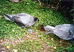
Three unique bird subspecies are the Lord Howe golden whistler, Lord Howe silvereye, and Lord Howe currawong. The famous flightless Lord Howe woodhen is the only one left of its kind. Its ancestors could fly, but they lost this ability because there were no predators and plenty of food on the island. This made them easy prey for people and wild animals. By the 1970s, there were fewer than 30 woodhens. From 1978 to 1984, wild animals were removed, and birds were raised in captivity. They were then successfully put back into the wild. Now, their population is safe and stable.
Mammals, Reptiles, and Amphibians
Only one native mammal lives on the islands: the large forest bat. The unique Lord Howe long-eared bat is known only from a skull and is now thought to be extinct. This may be because of the ship rats that were introduced.
Two native reptiles live on the island group: the Lord Howe Island skink and the Lord Howe Island gecko. Both are rare on the main island but more common on smaller islands nearby. The garden skink and the bleating tree frog were accidentally brought from mainland Australia.
Invertebrates: Insects and Snails

The Lord Howe Island stick insect disappeared from the main island after rats arrived in 1918. In 2001, a tiny group was found on Ball's Pyramid. They have been successfully bred in captivity. Soon, they will be brought back to the main island. The Lord Howe stag beetle is a colorful beetle seen in summer. Another unique animal, the Lord Howe flax snail, has also been affected by rats. It was once common but is now endangered. A breeding program is trying to save it.
Marine Life: Underwater World
The marine environments around Lord Howe Island are almost untouched. They have a mix of temperate, subtropical, and tropical species. This is because of cool ocean currents in winter and the warm East Australian Current in summer. Of the 490 fish species recorded, 13 are found only here. About 60% are tropical. Popular fish for angling include yellowtail kingfish and New Zealand bluefish. Game fish include marlin, tuna, and giant kingfish. More than 80 species of coral live in the reefs around the islands.
Different types of whales and dolphins live in or travel through the waters near the island. Bottlenose dolphins are seen most often. Humpback whales are slowly recovering, but their numbers passing the island are still much smaller than those along the Australian continent.
Historically, many whales like blue, fin, and sei whales lived in these waters. But they were severely hunted. Southern right and sperm whales were hunted the most. The area was even called the Middle Ground by whalers.
- Images of native fauna
-
Providence petrels on the summit of Mount Gower
-
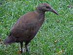
Woodhen by Neds Beach Road
-
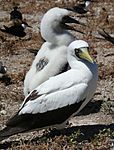
Masked booby with chick viewed off Malabar cliffs
-
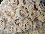
Coral Skeleton on Little Island Beach


Protecting Lord Howe Island's Nature

About 10% of Lord Howe Island's forests have been cleared for farming. Another 20% has been disturbed by farm animals and wild goats and pigs. However, 70% of the island remains mostly untouched. It has many unique plants and animals, some of which are rare or endangered. Since 1778, two plant species, nine land birds, one bat, and at least four invertebrates have become extinct.
The Lord Howe Island Board started a big study of the island's biology and environment in 1974. This study helps guide the island's conservation efforts. In 1981, a law created a "Permanent Park Preserve" over the north and south ends of the island. The National Parks and Wildlife Service manages this preserve. The island was named a UNESCO World Heritage Site in 1982.
The waters around the island are protected by the Lord Howe Island Marine Park. This park covers about 3,005 square kilometers (1,160 square miles). It includes the waters around the island and Ball's Pyramid.
Dealing with Invasive Species
Pigs and goats were brought to the island in the early 1800s for food. The goats destroyed plants that birds used for nesting. The pigs ate eggs and chicks. Several birds have become extinct since humans arrived. The Lord Howe swamphen, white-throated pigeon, and red-crowned parakeet were hunted by visitors or settlers.
In 1918, black rats accidentally arrived from a shipwreck. This caused a second wave of extinctions. Birds like the vinous-tinted thrush and Lord Howe starling disappeared. The native stick insect was also destroyed, and palm fruits were eaten. Rewards were offered for rat and pig tails. Later, poisoning programs helped keep rat numbers low. The Lord Howe boobook owl may have become extinct due to Tasmanian masked owls. These owls were brought in during the 1920s to control rats, but it did not work. Stray dogs are also a threat to native birds.
Invasive plants like Crofton weed and Formosa lily are hard to remove. But others are being managed. In 1995, efforts began to control plants like ground asparagus and bridal creeper. This led to weeding tours and the formation of the Friends of Lord Howe Island group in 2000. Programs have also started to remove weeds from private properties and replant native species.
Despite many introduced species harming Lord Howe's native plants and animals, wild pigs and cats were removed by the early 2000s. The goat population has been greatly reduced. Efforts continue to control rodents and introduced plants. In 2012, the Australian and NSW Governments agreed to pay for a A$9 million plan to remove rodents from the island using poison baits dropped from the air. This plan is still debated by the community. A recovery program has helped the Lord Howe woodhen population grow from only 20 birds in 1970 to about 200 in 2000.
Climate Change Impact
According to an analysis by Tim Flannery, Lord Howe Island's ecosystem is at risk from climate change and global warming. The reefs are threatened by rising water temperatures. The first international conference on using artificial photosynthesis to fight climate change happened at Lord Howe Island in 2011.
Heritage Status
The Lord Howe Islands Group is a World Heritage Site. It is recognized for its unique landforms, diverse ecosystems, natural beauty, and habitats for threatened species. It also has important cultural history for New South Wales.
Lord Howe Island and its nearby islets, including Ball's Pyramid, were added to the Australian National Heritage List in 2007. This was based on its World Heritage status. The island was also listed on the New South Wales State Heritage Register in 1999.
In 2019, it was revealed that a plan to install two wind turbines on the island was stopped. The project would have reduced the island's reliance on diesel power. It was considered safe for the island's heritage and supported by islanders.
Sports on the Island
- Lord Howe Island Bowling Club
- Lord Howe Island Golf Club
See also
 In Spanish: Isla de Lord Howe para niños
