Bounty Islands facts for kids
The Bounty Islands are a small group of 13 tiny islands and many rocks. They are made of granite and no one lives on them. These islands are in the South Pacific Ocean.
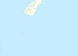
The total area of the islands is about 135 hectares (330 acres). They are part of New Zealand. The islands are located about 670 kilometers (420 miles) east-south-east of New Zealand's South Island. They are also 530 kilometers (330 miles) south-west of the Chatham Islands. The Antipodes Islands are 215 kilometers (134 miles) to the north. The Bounty Islands are a World Heritage Site, which means they are very important globally.
The Bounty Islands are considered part of the New Zealand outlying islands. They are directly part of New Zealand. However, they do not belong to any specific region or district. Instead, they are an Area Outside Territorial Authority. This is true for most of New Zealand's outlying islands.
Contents
History of the Bounty Islands
Captain William Bligh found the Bounty Islands in 1788. He was on his way from Spithead to Tahiti. He named the islands after his ship, HMS Bounty. This happened just a few months before the famous mutiny on his ship.
At first, the islands' exact location was not well known. In 1866, Commander W. H. Norman helped to map their position more accurately. Later, Captain George Palmer also mapped the islands. He officially claimed them for New Zealand.
During the 1800s, many sealers came to the area. They hunted seals around the islands. People also searched the islands for missing ships and their crews. This included those from the General Grant and the Matoaka.
In March 1886, the ship Hinemoa visited the islands. Its crew built a special storage place for sailors who might get stranded there. This depot was on the largest island. Captain Fairchild noted that there was no fresh water on the islands. By 1887, the sea had destroyed the depot. A new map of the area was made in 1888. In November 1891, the Hinemoa returned and built another storage area for supplies.
Plants and Animals
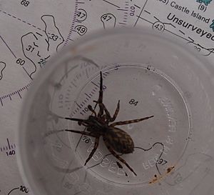
The islands are part of the Antipodes Subantarctic Islands tundra ecoregion. This means they have a cold, treeless environment. One plant found here is Cook's scurvy grass. The islands are home to a unique spider and special insects. They also have many seabirds.
Important Bird Area
The Bounty Islands are very important for birds. BirdLife International has named them an Important Bird Area (IBA). This is because many birds come here to breed. These include erect-crested penguins, Salvin's albatrosses, and Bounty shags.
Geography of the Bounty Islands
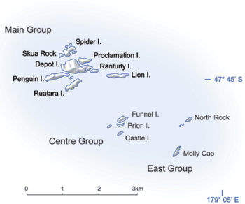
The entire chain of islands is only about 5 kilometers (3 miles) long. It has three main parts: the Main Group, the Centre Group, and the East Group. The total land area is very small, just 1.35 square kilometers (0.52 square miles). The islands are at the antipodes of Bouillé-Ménard, a town in France. This means they are directly opposite that town on the other side of the Earth.
The Main Group is the biggest of the three parts. It is in the northwest of the island chain. This group includes Depot Island, which is the largest island. It is about 700 meters (2,300 feet) long and 400 meters (1,300 feet) wide. Proclamation and Tunnel Islands are very close to Depot Island. They are connected at low tide. The northernmost point of the chain is a small islet near Spider Island. The westernmost point is the western tip of Penguin Island.
The Centre Group is about 1.5 to 2 kilometers (0.9 to 1.2 miles) southeast of the Main Group. It has three main islands in a line from north to south. A smaller islet is just to the west. Funnel Island, the northernmost island in this group, has the highest point of the whole chain. It is 73 meters (240 feet) above sea level.
The East Group is another 1.5 kilometers (0.9 miles) to the east. It is also arranged in a north-south line. Molly Cap is the largest island in this group and the southernmost island in the chain. It has the second-highest point, at 70 meters (230 feet) above sea level. This group also has two large islets, one small islet, and several reefs and rocks. One of these rocks is the easternmost point of the entire island chain.
Islands of the Bounty Group
- Main Group (47°45′S 179°02′E / 47.750°S 179.033°E):
- Depot Island (the largest island, named for the castaway depot)
- Dog Rock
- Lion Island
- Penguin Island
- Proclamation Island
- Ranfurly Island
- Ruatara Island
- Seal Rock
- Skua Rock
- Spider Island
- Tunnel Island
- Centre Group (47°45′45″S 179°02′40″E / 47.76250°S 179.04444°E):
- Coronet Island
- Funnel Island (the main islet)
- Prion Island
- East Group (47°46′S 179°04′E / 47.767°S 179.067°E):
- Con Island
- Molly Cap (the main islet)
- North Rock
See also
 In Spanish: Islas Bounty para niños
 | Emma Amos |
 | Edward Mitchell Bannister |
 | Larry D. Alexander |
 | Ernie Barnes |


