
New Zealand outlying islands facts for kids

The New Zealand outlying islands are nine special groups of islands. They are part of New Zealand but are located far away from the main islands, either in warmer (subtropical) or colder (subantarctic) waters. Even though they belong to New Zealand, most of these islands are not part of any regular region or district. Instead, they are called Area Outside Territorial Authority, which means they are managed directly by the central government.
There are two exceptions: the Chatham Islands have their own special local government, like a small council. The Solander Islands are part of the Southland Region.
Sometimes, the Balleny Islands are also included when people talk about New Zealand's outlying islands. These islands are near Antarctica and are part of the Ross Dependency, which is New Zealand's claim in Antarctica.
Five of these island groups are known as the New Zealand Subantarctic Islands. They are so special that they are a World Heritage Site. This means they are protected because of their unique nature and wildlife.
Island Groups: New Zealand's Faraway Lands
Here's a list of the island groups, going from north to south:
|
|
|||
 |
|||
| Island Group (other name) | Area (km2) |
Highest peak (m) | Location of main island |
|---|---|---|---|
| North of the North Island | |||
| Kermadec Islands (Rangitāhua) | 33.60 | Moumoukai Peak (516) | 29°16′S 177°55′W / 29.267°S 177.917°W |
| Three Kings Islands (Manawatāwhi, Ngā Motu Karaka) | 6.85 | (Great Island) (295) | 34°09′S 172°08′E / 34.150°S 172.133°E |
| East/south of the South Island | |||
| Chatham Islands (Rēkohu, Wharekauri) | 966.00 | (Chatham Island) (299) | 43°54′S 176°32′W / 43.900°S 176.533°W |
| Solander Islands (Hautere) | 1.20 | (Solander Island) (330) | 46°34′S 166°53′E / 46.567°S 166.883°E |
| New Zealand Subantarctic Islands | |||
| Bounty Islands | 1.35 | (Funnel Island) (73) | 47°46′S 179°02′E / 47.767°S 179.033°E |
| Snares Islands (Tini Heke) | 3.50 | (North East Island) (130) | 48°01′S 166°32′E / 48.017°S 166.533°E |
| Antipodes Islands | 21.00 | Mount Galloway (366) | 49°41′S 178°48′E / 49.683°S 178.800°E |
| Auckland Islands (Motu Maha, Maungahuka) | 625.64 | Mount Dick (705) | 50°42′S 166°05′E / 50.700°S 166.083°E |
| Campbell Islands (Motu Ihupuku) | 113.31 | Mount Honey (558) | 52°32′S 169°09′E / 52.533°S 169.150°E |
| Outlying Islands | 1772.4 | Mount Dick (705) | |
Population: Who Lives on These Islands?
Most of these islands are not lived on by people. The only island group with a permanent population is the Chatham Islands.
There is a weather station on Raoul Island in the Kermadec Islands, where people work. The weather station on Campbell Island has been automated since 1995, meaning no people work there anymore. There was also a weather station on the Auckland Islands for a few years during World War II.
Some of these islands, like the Three Kings Islands and the Auckland Islands, used to have people living on them a long time ago. There were also attempts to start settlements on Raoul Island, the Antipodes Islands, and the Auckland Islands, but these attempts didn't work out. The Solander Islands have never had permanent residents, except for a few sailors who were shipwrecked or accidentally left behind.
Images for kids
-
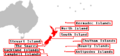
Map of the New Zealand outlying islands in relation to the main New Zealand Archipelago
