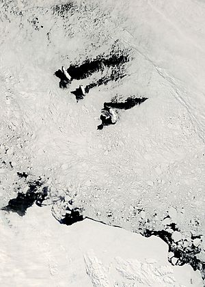
Balleny Islands facts for kids

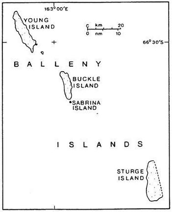
Map of the Balleny Islands
|
|
|
Location in Antarctica
|
|
| Geography | |
|---|---|
| Location | Antarctica |
| Coordinates | 66°55′S 163°45′E / 66.917°S 163.750°E |
| Archipelago | Balleny Islands |
| Area | 800 km2 (310 sq mi) |
| Highest elevation | 1,705 m (5,594 ft) |
| Highest point | Brown Peak |
| Administration | |
| Administered under the Antarctic Treaty System | |
| Demographics | |
| Population | Uninhabited |
The Balleny Islands are a group of islands far south in the Southern Ocean. They are very cold and covered in ice. These islands stretch for about 160 kilometers (100 miles) from northwest to southeast. They were formed by volcanoes, and glaciers flow from them right into the sea.
No one lives on the Balleny Islands. They are part of the Ross Dependency, which is an area claimed by New Zealand in Antarctica.
Contents
Main Islands and Rocks
The Balleny Islands group has three main islands. They are called Young, Buckle, and Sturge. These islands line up from northwest to southeast. There are also several smaller islets and rocks nearby.
- Near Young Island, you can find Seal Rocks and Pillar.
- Southeast of Young Island are Row Island and Borradaile Island. Borradaile Island has a small shelter hut called Swan Base.
- South of Buckle Island are Scott Cone, Chinstrap Islet, Sabrina Islet, and a rock formation called The Monolith. Sabrina Islet also has a small shelter hut.
The total area of all the islands is about 400 square kilometers (150 square miles). The highest point is Brown Peak on Sturge Island. It is about 1,705 meters (5,594 feet) tall, but no one has ever climbed it.
The Antarctic Circle passes very close to Borradaile Island. This is in the channel between Young and Buckle Islands. Buckle Island and nearby Sabrina Island are home to many Adelie and chinstrap penguins.
Who Visited the Islands?
The Balleny Islands were first seen in 1839. This happened during a trip by English seal hunters, John Balleny and Thomas Freeman. John Balleny named the islands after himself. He named the individual islands after the people who helped pay for his trip.
Thomas Freeman was the first person to step onto any of these islands. This happened on February 9, 1839. It was the first time anyone had landed south of the Antarctic Circle. Other sealers saw the islands in 1853 but did not land.
In February 2015, a research ship visited the islands for three days. This was part of the New Zealand-Australia Antarctic Ecosystems Voyage. Scientists studied the marine life around the islands, especially humpback whales. They had done similar research in 2010.
On February 3, 2017, another group of scientists visited. They were from the Swiss Polar Institute's Antarctic Circumnavigation Expedition. They took many photos and videos to help make better maps of the islands. They used helicopters and small inflatable boats to explore and land on the islands.
Island Geology
The main islands, Buckle, Sturge, and Young, are all stratovolcanoes. This means they are cone-shaped volcanoes built up by many layers of hardened lava and ash.
Strong earthquakes are rare very close to the islands. However, smaller earthquakes do happen in the ocean areas nearby. These quakes are linked to large underwater mountain ranges and fault lines. For example, a big earthquake happened in 1998 about 700 kilometers (435 miles) west of the islands. It was so strong it changed how earthquakes happened in the whole area.
It's possible that these islands are still active volcanoes. Scientists think that Brown Peak on Sturge Island might have erupted in 2001. This idea comes from satellite observations.
Underwater Features
Several interesting features are found underwater near the Balleny Islands:
- Balleny Seamounts (underwater mountains)
- Balleny Trough (a deep underwater valley)
- Umitaka Bank (an underwater plateau)
- Vaughan Bank (another underwater plateau)
See also
 In Spanish: Islas Balleny para niños
 | Bayard Rustin |
 | Jeannette Carter |
 | Jeremiah A. Brown |


