Manawatāwhi / Three Kings Islands facts for kids
|
Manawatāwhi or Ngā Motu Karaka
|
|
|---|---|
| Geography | |
| Coordinates | 34°09′14″S 172°8′24″E / 34.15389°S 172.14000°E |
| Total islands | 13 |
| Area | 6.85 km2 (2.64 sq mi) |
| Highest elevation | 295 m (968 ft) |
| Administration | |
| Demographics | |
| Population | None |
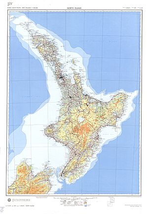
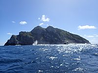
The Three Kings Islands are a group of 13 islands located about 55 kilometers (34 miles) northwest of Cape Reinga in New Zealand. These islands are also known by their Māori name, Manawatāwhi, which refers to the largest island in the group. They are found where the Pacific Ocean and the Tasman Sea meet.
The islands cover an area of about 6.85 square kilometers (2.64 square miles). They sit on a raised area under the sea called the Three Kings Bank. A deep underwater valley, about 8 kilometers (5 miles) wide and 200 to 300 meters (650 to 980 feet) deep, separates them from mainland New Zealand. Because of this, the Three Kings Islands are considered part of New Zealand's Outlying Islands. They are a direct part of New Zealand but do not belong to any specific region or district.
Contents
History of the Three Kings Islands
The Three Kings Islands, or Manawatāwhi, were traditionally home to the Māori people from the Muriwhenua tribe. In Māori mythology, the island of Ōhau (West Island) is believed to be the last place spirits see New Zealand before they leave the world from Cape Reinga / Te Rerenga Wairua. Some stories from the Te Aupōuri tribe say the name Manawatāwhi, meaning "panting breath," comes from an ancestor named Rauru. He swam to the islands and arrived very tired. Members of the Ngāti Kurī tribe sometimes used the islands as a safe place during wars. They also visited to gather hāpuku fish, seabirds, and eggs.
Most of the bigger islands were once lived on. Māori people cleared land on Great Island to grow crops like kūmara (sweet potato). There are no signs of defensive pā (fortified villages) on the islands. This suggests that the people living on Manawatāwhi felt safe because the islands were far from the mainland.
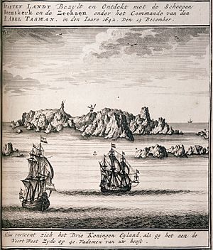
The Dutch explorer Abel Tasman was the first European to see New Zealand. Three weeks later, on January 6, 1643, he named these islands Drie Koningen Eyland (Three Kings Island). Tasman stopped at the islands to look for fresh water. It was the Twelfth Night, a holiday celebrating the Epiphany. This is the day when the Bible says the three wise men visited baby Jesus. So, Tasman named the main island after them. He also named a nearby cape Cape Maria van Diemen after the wife of Anthony van Diemen, who was a governor. These two names are the only ones given by Abel Tasman that are still used in New Zealand today. Tasman saw about 30 to 35 people living on the island when he tried to land for water. He also noticed there were no trees on the island at that time. After Tasman, other European ships, like the Recherche with French botanist Jacques Labillardière in 1793, also sighted the islands.
In the late 1700s, a group from the mainland Te Aupōuri tribe, led by Taiakiaki, traveled to the islands. They killed the approximately 100 people living there, who were led by Toumaramara. Between 1800 and 1830, the Te Aupōuri tribe visited the islands sometimes but did not settle there permanently. Tame Porena, also known as Tom Bowline, married Taiakiaki's granddaughter. He and his family of twelve children lived on the islands in the 1830s and 1840s. They grew large gardens, but eventually, they had to move back to the mainland because of a lack of food. Since then, no one has lived on the islands permanently.
The botanist Thomas Frederic Cheeseman visited the islands in 1887 and 1889. He was the first to record the different plant species found there. Cheeseman observed that Great Island had started to grow trees again after the Māori people had left.
The New Zealand government bought the islands in 1908. In 1930, they were declared an animal sanctuary. A group of goats had been left on Manawatāwhi Island in November 1889 to provide food for shipwrecked sailors. These goats had multiplied greatly, reaching 300 to 400 by 1900. This large number of goats was causing a lot of damage to the island's plants. Baden Powell from the Auckland War Memorial Museum visited the islands and asked the government to deal with the goat problem. In 1946, the goats were removed from the island. This allowed the forests on Manawatāwhi to grow back. However, 50 plant species that Cheeseman described in the 1880s have not been seen since. By the 1980s, only one wild plant was left for two other species. In 1956, the islands were officially made a reserve to protect their plants and animals.
Geography of the Three Kings Islands
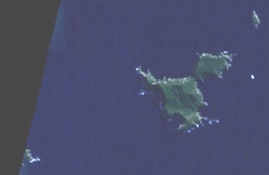
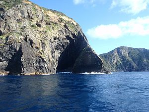
The Three Kings Islands are divided into two main groups. They include four large, rugged islands and many smaller rocks. These islands sit on an underwater plateau called King Bank, which rises from very deep ocean water. There are no sandy beaches on the islands. The sea around them is very clear and full of fish, making it a popular spot for divers. Another interesting feature is the wreck of the ship Elingamite, which sank there on November 9, 1902.
King Group Islands
Manawatāwhi (Great Island)
Manawatāwhi, also known as Great Island, is the largest island in the group. It covers about 4.04 square kilometers (1.56 square miles). A part of the island in the northeast, about 1 square kilometer (0.39 square miles) in size, is almost separated from the rest. It's connected by a narrow strip of land, 200 meters (650 feet) wide and over 80 meters (260 feet) high. This strip is formed by North West Bay and South East Bay. The island's highest point is 295 meters (968 feet) in the western part. The northeastern section reaches 184 meters (604 feet) near its cliffs. The southern part of the island has rolling hills called the Tasman Valley, where the Tasman Stream flows. Most of the old Māori sites on the islands are found in this area.
Oromaki (North East Island)
Oromaki is a smaller island, about 0.10 square kilometers (0.039 square miles) in size. It reaches a height of 111 meters (364 feet) and is located about 1 kilometer (0.62 miles) northeast of Manawatāwhi. The island is surrounded by tall cliffs, 70 to 90 meters (230 to 300 feet) high. You can find old Māori stonework and terraced areas on this island.
Farmers Rocks
Farmers Rocks are small rocks located 0.8 kilometers (0.5 miles) east of Great Island. They are only 5 meters (16 feet) high and cover just a few hundred square meters.
Southwest Group Islands
Moekawa (South West Island)
Moekawa is the second largest island in the group, covering about 0.38 square kilometers (0.15 square miles). It is 207 meters (679 feet) high and lies about 4.5 kilometers (2.8 miles) southwest of Great Island. This island is also surrounded by high cliffs, ranging from 80 to 120 meters (260 to 390 feet) tall.
The Princes Islands
The Princes Islands are a group of seven small islets and many rocks. Their total area is about 0.2 square kilometers (0.077 square miles). They start 600 meters (2,000 feet) west of South West Island and stretch about 1.8 kilometers (1.1 miles) from east to west. The highest islet in this group is 106 meters (348 feet) tall. The smallest islet is called Rosemary Rock. These islands do not have much plant life.
Ōhau (West Island)
Ōhau is the third largest island, with an area of 0.16 square kilometers (0.062 square miles). It is located 500 meters (1,600 feet) southwest of the westernmost Princes Island. Ōhau is 177 meters (581 feet) high and is surrounded by cliffs that are 40 to 130 meters (130 to 430 feet) tall.
This island is very important in traditional Māori beliefs. It is thought to be the place where the spirits of dead Māori say their final goodbyes to New Zealand before traveling to their ancestral homeland of Hawaiki. Near Cape Reinga on the mainland, there is an old Pōhutukawa tree, said to be over 800 years old. Māori tradition says that spirits journey to this tree and go down its roots into the seabed. They are then believed to come back to the surface on Ōhau Island for one last farewell before continuing their journey to Hawaiki.
Flora and Fauna of the Three Kings Islands
Flora (Plants)
In 1945, a scientist named G. T. S. Baylis made an amazing discovery on the Three Kings Islands. He found the very last wild plant of a tree species now known as Pennantia baylisiana, a type of kaikōmako. This tree was recognized around the world as the rarest and most endangered tree. Thanks to careful efforts to grow new plants in New Zealand, this species is now growing well, but it is still watched closely. The islands were made a wildlife sanctuary in 1995 to protect their unique plants and animals. Other plants that are found only on these islands include Tecomanthe speciosa and Elingamita johnsonii.
Fauna (Animals)
The Three Kings Islands have a very high number of unique animal species, especially when compared to other isolated islands. This is called a high level of endemism, meaning many species are found nowhere else in the world. For example, about 35% of the beetle species on these islands are found only there. There are also six types of beetles that belong to groups (genera) found only on the Three Kings Islands. These include Gourlayia (a ground beetle), Heterodoxa and Pseudopisalia (both rove beetles), Partystona and Zomedes (both darkling beetles), and Tribasileus (a fungus weevil). Scientists believe there might be seven more unique beetle groups yet to be officially described.
The Falla's Skink (Oligosoma fallai) is a type of lizard that lives only on these islands.
Nature Reserve
The Three Kings Islands are a special nature reserve managed by the Department of Conservation. Unlike many other islands, rats and mice were never introduced to the Three Kings. However, goats were brought to Great Island and caused a lot of damage to the plants and soil. After the goats were removed, the natural environment began to recover.
 | Frances Mary Albrier |
 | Whitney Young |
 | Muhammad Ali |


