
Chatham Islands facts for kids

The two largest islands: Chatham and Pitt Island, to the southeast
|
|
.svg)
Location of the Chatham Islands
|
|
| Geography | |
| Location | Southern Pacific Ocean |
| Coordinates | 44°02′S 176°26′W / 44.033°S 176.433°W |
| Total islands | 10 |
| Major islands | |
| Area | 966 km2 (373 sq mi) |
| Highest elevation | 299 m (981 ft) |
| Administration | |
| Largest settlement | Waitangi |
| Demographics | |
| Population | 600 |
| Additional information | |
| Time zone |
|
| • Summer (DST) |
|
The Chatham Islands (pronounced CHAT-əm) are a group of islands in the Pacific Ocean. They are about 800 kilometers (500 miles) east of New Zealand's South Island. These islands are part of New Zealand. The group has about 10 islands spread out over a 60-kilometer (37-mile) area. The two biggest islands are Chatham Island and Pitt Island. The Forty-Fours are the easternmost point of New Zealand. Some islands used to be farms, but now they are nature reserves. This helps protect their special plants and animals.
The islands were empty when the Moriori people arrived around 1500 CE. They developed a peaceful way of life. In 1835, Māori groups called Ngāti Mutunga and Ngāti Tama from New Zealand's North Island came to the islands. They took control and made the Moriori people their servants. Later, when Europeans were settling New Zealand, the New Zealand Company tried to sell the Chatham Islands to Germany. But the sale didn't happen. The Chatham Islands officially became part of the Colony of New Zealand in 1842. In 1863, the Moriori were finally freed.
The Chatham Islands have about 600 people living there. Waitangi is the main town and port. The local economy relies on protecting nature, tourism, farming, and fishing. The Chatham Islands Council manages the local area. The Chatham Islands have their own time zone, which is 45 minutes ahead of the rest of New Zealand.
Contents
Geography
The Chatham Islands are about 840 kilometers (520 miles) east of Christchurch, New Zealand. The closest point on New Zealand's mainland is Cape Turnagain on the North Island, which is about 650 kilometers (400 miles) away. The two largest islands, Chatham Island and Pitt Island, make up most of the total land area of 793.87 square kilometers (306.5 square miles). There are also 12 smaller islands scattered around.
The islands sit on the Chatham Rise. This is a large, mostly underwater part of the Zealandia continent. It stretches east from near New Zealand's South Island. The Chatham Islands are the only part of the Chatham Rise that is above the sea. They appeared above water only in the last 4 million years.
The islands are hilly, with coasts that have cliffs, sand dunes, beaches, and lagoons. Pitt Island is more rugged than Chatham Island. Its highest point is 299 meters (981 feet) high. Chatham Island has many lakes and lagoons. The largest is Te Whanga Lagoon. There are also several streams, like Te Awainanga and Tuku.
Chatham and Pitt are the only islands where people live. The smaller islands are nature reserves. People are not allowed to visit them, or their access is very limited. The people living on the islands make their living from farming and fishing, especially catching crayfish. Tourism is also becoming more important.
Here are the names of the main islands:
| English name | Moriori name | Māori name |
|---|---|---|
| Chatham Island | Rēkohu | Wharekauri |
| Pitt Island | Rangiaotea | Rangiauria |
| South East Island | Hokorereoro | Rangatira |
| The Fort | Maung’ Rē | Māngere |
| Little Mangere | Unknown | Tapuenuku |
| Star Keys | Motchu Hopo | Motuhope |
| The Sisters | Rakitchu | Rangitatahi |
| Forty-Fours | Motchu Hara | Motuhara |
Climate
The Chatham Islands have an oceanic climate. This means they have a small range of temperatures and it rains quite often. Because they are far from any large land, the weather is cool, wet, and windy. In summer, the average high temperatures are between 15 and 20 °C (59 and 68 °F). In July (winter in the Southern Hemisphere), they are between 5 and 10 °C (41 and 50 °F). Snow almost never falls.
| Climate data for Chatham Islands (1981–2010) | |||||||||||||
|---|---|---|---|---|---|---|---|---|---|---|---|---|---|
| Month | Jan | Feb | Mar | Apr | May | Jun | Jul | Aug | Sep | Oct | Nov | Dec | Year |
| Mean daily maximum °C (°F) | — | — | — | — | 13.0 (55.4) |
— | — | — | — | — | — | — | 14.1 (57.4) |
| Daily mean °C (°F) | — | — | — | — | 10.6 (51.1) |
— | — | — | — | — | — | — | 11.5 (52.7) |
| Mean daily minimum °C (°F) | — | — | — | — | 8.1 (46.6) |
— | — | — | — | — | — | — | 9.0 (48.2) |
| Average rainfall mm (inches) | — | — | — | — | 87.9 (3.46) |
— | — | — | — | — | — | — | 911.3 (35.88) |
| Average rainy days (≥ 1.0 mm) | — | — | — | — | 14.4 | — | — | — | — | — | — | — | 140.1 |
| Average relative humidity (%) | — | — | — | — | 85.7 | — | — | — | — | — | — | — | 84.1 |
| Mean monthly sunshine hours | — | — | — | — | 81.2 | — | — | — | — | — | — | — | 1,437.3 |
The Chatham Islands' time zone
The International Date Line is east of the Chatham Islands. This means the islands are ahead of most of the world in time. The Chathams have their own time zone, which is 45 minutes ahead of New Zealand time. This is true even during daylight saving. It's one of the few places in the world where the time difference isn't a full hour or half-hour.
Ecology


The islands used to have a mix of forests, scrubby areas, and swamps. Today, much of the land is covered in ferns or used for pasture. However, some areas still have thick forests, peat bogs, and other natural habitats. The akeake trees are interesting because their branches grow almost flat due to the strong winds.
The islands are home to many different living things. There are about 50 unique plants that only grow here, adapted to the cold and wind. These include the Chatham Islands forget-me-not (Myosotidium hortensia), the Chatham Islands sow-thistle (Embergeria grandifolia), and the Chatham Island akeake tree (Olearia traversiorum).
Many seabirds breed on the islands. There are also several birds found only on the Chathams. Some well-known ones are the magenta petrel and the black robin. Both of these birds were almost extinct but were saved by conservation efforts. Other unique birds include the Chatham oystercatcher, the Chatham gerygone, and the Chatham pigeon. Some birds like the Chatham shag and the Chatham albatross are in danger from fishing gear.
Sadly, some species have become extinct since people arrived. These include the Chatham raven and three types of flightless rails.
Many marine mammals also live in the waters around the Chathams. These include New Zealand sea lions, leopard seals, and southern elephant seals. Many whale species come here because there is a lot of food.
Much of the natural forest has been cleared for farming. But Mangere and Rangatira Islands are now nature reserves. This helps protect the unique plants and animals. Another danger to wildlife comes from introduced species (animals brought by humans) that hunt the native birds and reptiles. On Mangere and Rangatira, farm animals have been removed, and native wildlife is recovering.
History

Moriori people
The first people to live on the Chatham Islands were Polynesian groups. They likely settled the islands around 1500 CE. Because they were so isolated, they developed into the Moriori people. They could not grow the same plants as in their old home, so the Moriori became hunter-gatherers and fishermen. They also invented special boats called waka kōrari made of flax and kelp. These boats helped them travel to outer islands to collect birds. The Moriori society was peaceful. Their chief, Nunuku-whenua, made a rule against fighting and bloodshed after many years of wars. Arguments were settled by talking or by duels that stopped as soon as blood was drawn. Before Europeans arrived, about 2,000 Moriori lived on the islands.
European arrival
The Chatham Islands got their name from William Pitt, 1st Earl of Chatham. A British ship, HMS Chatham, landed on the islands on November 29, 1791. Its captain, William Robert Broughton, claimed the islands for Great Britain. The islands celebrate their anniversary on November 29.
Soon, seal hunters and whalers started using the islands as a base. It is thought that 10 to 20 percent of the Moriori people died from diseases brought by these visitors. Sealing and whaling stopped around 1861, but fishing remained important.
Māori settlement
In November and December 1835, about 900 Ngāti Mutunga and Ngāti Tama Māori people arrived on a ship called the Lord Rodney. They had come from New Zealand's North Island. They brought seeds, pigs, and large canoes.
The Moriori people welcomed the Māori at first. But soon, the Māori began to claim the land. The Moriori met to decide what to do. They chose to stick to their peaceful ways and not fight. However, the Māori saw this meeting as a sign of war and attacked. They killed many Moriori and made the survivors their servants. The Moriori were not allowed to marry each other or have children together. The Māori kept the Moriori as servants until 1863, when they were officially freed. By then, only about 160 Moriori remained.
In 1840, a ship from the New Zealand Company arrived. The company wanted to buy land for settlement. The Treaty of Waitangi did not apply to the islands at that time. The company even tried to set up a German colony on the Chathams in 1841, but this plan failed. The company then bought large areas of land from both Māori groups. An uneasy peace was made in 1842.
In 1865, the Māori leader Te Kooti was sent to the Chatham Islands. He was exiled there with a group of Māori rebels called the Hauhau. They had fought against the government in New Zealand. The prisoners worked on sheep farms for European settlers. They also helped build roads. In 1868, Te Kooti and the other prisoners took over a ship and escaped back to the North Island. Most Māori returned to Taranaki in the 1860s.
1880s to today
The Chatham Islands' economy, which mainly relied on exporting wool, struggled in the 1880s. It improved when fish freezing plants were built in 1910. A wharf was built at Waitangi in the 1930s. During World War II, a German ship sank the Chatham Islands' supply ship, the Holmwood. A flying-boat service then started and continued until 1966.
After World War II, the islands' economy suffered again because they were so isolated. Many young people left for mainland New Zealand. A brief boom in crayfish fishing helped the economy in the late 1960s and early 1970s. Since the early 2000s, cattle farming has become a big part of the local economy.
Moriori community
Today, the Moriori community is organized as the Hokotehi Moriori Trust. The New Zealand government has recognized the Moriori as the original people of the Chatham Islands. They have also recognized the Ngāti Mutunga Māori as having lived there for about 160 years.
The islands' population is about 600 people, including both Moriori and Māori descendants. In 2005, the Moriori opened their new meeting house, Kopinga Marae. Both Moriori and Māori groups now share in ancestral Māori fishing rights.
Population

The Chatham Islands cover 793.87 square kilometers (306.5 square miles). In 2018, the population was 663 people. This was an increase of 63 people since the 2013 census. There were 276 households. There were more males (354) than females (312). The average age was 41.9 years. About 16.7% of the people were under 15 years old.
Most people (74.2%) identified as European/Pākehā, and 66.1% as Māori. Some people identified with more than one ethnicity. About 5.9% of people were born outside New Zealand.
The town of Waitangi is the main settlement with 177 residents. Other villages include Owenga, Te One, and Kaingaroa. There are two primary schools in Kaingaroa and Te One. A third school is on Pitt Island.
Waitangi has a hospital with a doctor, a bank, several stores, and services for boats. The main shipping wharf is also here.
Transport

Most visitors fly to the Chathams from Auckland, Christchurch, or Wellington. The flight to Tuuta Airport on Chatham Island takes about 2 hours from Christchurch. While cargo usually arrives by ship (a 2-day journey), the sea trip is too long for many passengers and not always available.
There is no public transport on the islands. However, places where you stay can usually help arrange rides.
In the past, flying boats and then Bristol Freighter aircraft served the islands. These planes were slow and noisy. They were mainly used to ship valuable crayfish products. The old grass landing field was difficult for many planes.
In 1981, a sealed runway was built at Karewa, at Tuuta Airport. This allowed more modern aircraft to land safely. The Chathams' own airline, Air Chathams, now flies to Auckland, Wellington, and Christchurch. They use twin-engine turboprop planes.
A ship called the MV Southern Tiare provides freight service between Napier, Timaru, and the Chathams.
There is a small paved road between Waitangi and Te One. But most of the roads on the islands are gravel.
Government

Local government
The Chatham Islands are managed by the Chatham Islands Council. This council acts like both a district council and a regional council, meaning it handles many local services. The Council has a directly elected mayor and eight council members.
State services
The police force on the islands is usually just one constable. This officer often helps with other government jobs too, like court duties or customs.
A District Court judge comes from the North or South Island for court hearings.
Because the islands are isolated and have a small population, some rules are more relaxed. For example, drivers on the Chathams don't have to keep detailed logbooks of their driving hours like on the mainland.
Health
The Canterbury District Health Board is in charge of providing health services for the island.
Education
There are three schools on the Chathams: at Kaingaroa, Te One, and Pitt Island. The schools on Pitt Island and Kaingaroa each have one principal who also teaches. Te One school has three teachers and a principal. These schools teach children from Year 1 to Year 8 (ages 5-13). There is no high school. Most high school students leave the island to go to boarding schools in mainland New Zealand. A few stay on the island and study from home using online courses.
Economy
Most of the Chatham Islands' economy comes from fishing, especially catching crayfish. A small part of the economy is from adventure tourism. This mix has been steady for the last 50 years. There isn't much industry or advanced technology because of the small population and limited infrastructure.
Air Chathams has its main office in Te One.
Electricity generation
Chatham Island gets its power from two large wind turbines and diesel generators. The cost of electricity here is much higher than in mainland New Zealand. In 2014, 65% of the electricity came from diesel generators, and the rest from wind. For heating, wood is used more than electricity. Solar power also provides some energy.
Telecommunications
The islands first got a wireless link in 1913. A public radio link to the mainland was built in 1953, and a local phone system in 1965. In 2014, the islands got better internet as part of a national plan. Now, broadband internet is available through satellite.
Until recently, there was no mobile phone service on the islands. But in December 2021, five 4G cell towers were turned on. This brought mobile phone service to Chatham and Pitt Island and made broadband faster. The main tower sends signals to the others, and the internet connection goes to Wellington via satellite.
Notable people
- Richard Charteris (musicologist) (born 1948), a music expert from New Zealand.
- Te Kiato Riwai (1912–1967), a New Zealand nurse and Māori welfare officer.
See also
 In Spanish: Islas Chatham para niños
Images for kids
-
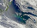
Massive phytoplankton bloom around the islands
-

Chatham Islands Forget-me-not (Myosotidium hortensia)
-
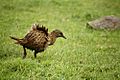
A weka on Chatham Island
-
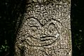
Moriori tree carving, or dendroglyph, found in the Chatham Islands
-
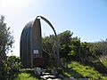
Monument to Torotoro above Kaingaroa Beach on Chatham Island
-
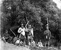
Moriori people in the late 19th century
-
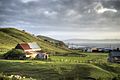
An agricultural scene on the islands
-
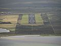
Visitors to the Chathams generally arrive in the islands via Tuuta Airport.


