Chatham Island facts for kids

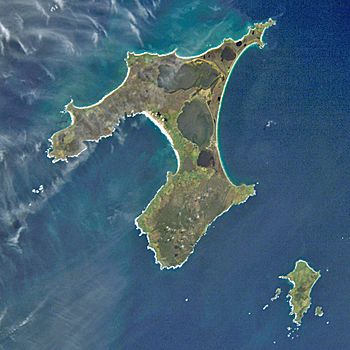
Chatham Island (left) from space
|
|

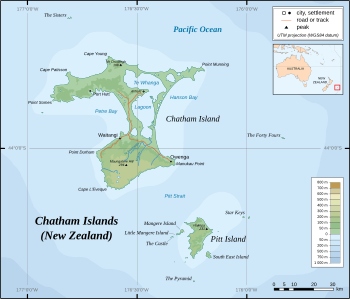
Map showing location of Chatham Island
|
|
| Geography | |
| Coordinates | 43°54′S 176°29′W / 43.900°S 176.483°W |
| Archipelago | Chatham Islands |
| Area | 920 km2 (360 sq mi) |
| Administration | |
| Demographics | |
| Population | 600 (2013) |
| Ethnic groups | Moriori |
Chatham Island is the biggest island in the Chatham Islands group. It is located far out in the Pacific Ocean, off the eastern coast of New Zealand's South Island. People sometimes say it is "halfway between the equator and the pole," and it is also very close to the International Date Line.
The island has special names: Rekohu (meaning "misty skies") in the Moriori language, and Wharekauri in the Māori language. It was named after the survey ship HMS Chatham, which was the first European ship to find the island in 1791. Chatham Island is about 920 square kilometers in size. It is located about 650 kilometers southeast of Cape Turnagain, which is the closest point of mainland New Zealand.
Island Geography
Chatham Island has a shape like a "T" and is known for three main features. These are two large bays and a big lagoon. Over half of the western side of the island is taken up by a deep curve called Petre Bay.
The main town on the island, Waitangi, is found in a smaller curve on the southern coast of Petre Bay. Other important towns include Kaingaroa on the northeast side, and Owenga on the south side of Hanson Bay.
On the eastern coast, you will find an even bigger bay called Hanson Bay. This bay stretches along the entire length of the island, which is about 35 kilometers.
Te Whanga Lagoon
A large part of the area between the two bays is filled by the huge Te Whanga Lagoon. This lagoon empties into the sea on the eastern side, flowing into the southern part of Hanson Bay.
Te Whanga Lagoon covers about 160 square kilometers. Several small rivers that start in the hills at the southern end of the island flow into it. The next largest lakes are Rangitahi and Huro, located northeast and southwest of Te Whanga.
Island Landscape
The central and northern parts of Chatham Island are mostly flat. Their height above sea level ranges from a few meters in the northeast and center to 50 meters in the northwest. There are also a few scattered small hills.
The southern part of the island is higher, generally sloping down towards the north and west. About half of this area is more than 150 meters above sea level. The southern coast of the island mostly has cliffs that are 100 meters high or more. The highest point on the island is 299 meters high and is located near its southernmost tip.
Island Wildlife
Chatham Island is a special place for wildlife. It is the only known breeding ground for the Magenta petrel. This bird is unique to the island and is critically endangered, meaning it is at very high risk of disappearing forever.
See also
 In Spanish: Isla Chatham para niños
 | Mary Eliza Mahoney |
 | Susie King Taylor |
 | Ida Gray |
 | Eliza Ann Grier |


