Pitt Island facts for kids

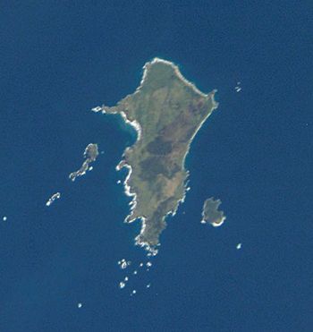
Pitt Island from space
|
|

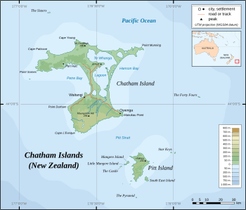
Map showing location of Pitt Island
|
|
| Geography | |
| Coordinates | 44°17′15″S 176°13′12″W / 44.28750°S 176.22000°W |
| Archipelago | Chatham Islands |
| Area | 65 km2 (25 sq mi) |
| Highest elevation | 241 m (791 ft) |
| Highest point | Waihere |
| Administration | |
| Demographics | |
| Population | 38 (2011) |
| Pop. density | 0.59 /km2 (1.53 /sq mi) |
Pitt Island is the second largest island in the Chatham group of islands, part of New Zealand. It is known as Rangiauria in Māori. The Moriori people call it Rangiaotea.
This island covers about 65 square kilometres (25 sq mi) (25 sq mi). It is located about 770 kilometres (480 mi) (478 mi) east of New Zealand's main islands. Pitt Island is also about 20 kilometres (12 mi) (12 mi) southeast of Chatham Island. The Pitt Strait separates these two islands.
Pitt Island is quite hilly. Its highest point, Waihere Head, reaches 241 metres (791 ft) (791 ft) above sea level. In 2011, around 38 people lived on Pitt Island.
A special fact about Pitt Island is that its Kahuitara Point is the first place on Earth where people can see the sunrise each new year. This is based on its local time zone.
Contents
Island History and Names
Early Settlers and Discoveries
Pitt Island was first home to the Moriori people. They are the original people of the Chatham Islands. They called the island Rangiaotea or Rangihaute. You can find their old tools and remains almost everywhere on the island. This shows how long they lived there.
The first Europeans to see the Chatham Islands were from Captain William Robert Broughton's ship, HMS Chatham. However, they did not see Pitt Island itself. The first European to spot Pitt Island was Captain Charles Johnston. He saw it in May 1807 from his ship, HMS Cornwallis.
How Pitt Island Got Its Name
Captain Johnston named the island 'Pitt's Island'. He named it after William Pitt, 1st Earl of Chatham. Later, in 1840, the name was made simpler to "Pitt Island".
In 1835, Taranaki Māori people came to the Chatham Islands. They called Pitt Island Rangiauria. This name is still used today.
Shipwrecks Around the Island
Over the years, many ships have been wrecked near Pitt and Chatham Islands. One such ship was the Glory. This Australian sealing ship was wrecked on Pitt Island in January 1827. The place where it sank is now known as Glory Bay.
Life and Work on Pitt Island
Island Economy
The people living on Pitt Island earn their money in a few ways. They work in farming, commercial fishing, and tourism. The New Zealand Department of Conservation also works on the island. They help manage special protected areas and nature reserves with landowners.
The island needs to bring in fuel and most manufactured goods from other places. In return, it sends live sheep and cattle to mainland New Zealand.
Facilities and Transport
Pitt Island has a school for its children. It also has a wharf where ships can dock. There is a church and a grass airstrip for small planes. A gravel road connects Flower Pot Bay to the airstrip.
A supply ship visits Pitt Island about every three months. This ship brings important goods to the island. Each home on the island makes its own electricity. They use either diesel generators or wind turbines. Most homes also have satellite TV and broadband internet connections.
People on the island mostly travel using quad bikes or four-wheel drive vehicles. Sometimes, they even use horses. In 2011, the Pitt Island School had eight students. They were between 6 and 12 years old.
Air Chathams provides flights between Pitt Island and Chatham Island. They use a Cessna 206 aircraft for these trips.
Animals and Plants
On Pitt Island, you can find several groups of feral Saxon Merino sheep. These sheep live in the wild.
See also
 In Spanish: Isla Pitt (Chatham) para niños
 | Kyle Baker |
 | Joseph Yoakum |
 | Laura Wheeler Waring |
 | Henry Ossawa Tanner |


