Otago Peninsula facts for kids
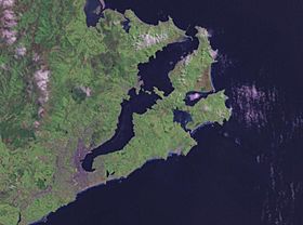
The Otago Peninsula (called Muaūpoko in Māori) is a long, hilly piece of land that forms the eastern part of Dunedin, New Zealand. It was made by a volcano long ago and now forms one side of the Otago Harbour. The peninsula stretches for 20 kilometres and is up to 9 kilometres wide. It connects to the main land by a narrow strip of land about 1.5 kilometres wide.
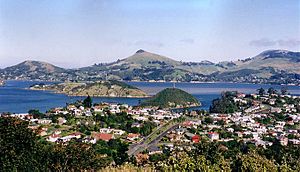
Some parts of Dunedin city are on the western end of the peninsula. There are also seven small towns and communities along the harbour side. Most of the land is open farmland with steep hills. The peninsula is a special home for many wild animals, especially seabirds, seals, and penguins. Many businesses offer tours to see this amazing wildlife.
Contents
Geography of Otago Peninsula
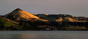
The Otago Peninsula was formed by a huge, ancient volcano about 10 to 13 million years ago. You can still see its volcanic past in the shape of some hills, like the aptly named Harbour Cone.
Most of the peninsula is steep and hilly. The highest points are Mount Charles (408 metres), Harbour Cone, and Sandymount. There are two tidal inlets on the Pacific Ocean side: Hoopers Inlet and Papanui Inlet. Between them is Cape Saunders. Other cool natural spots include the 250-metre-high cliffs of Lovers' Leap and The Chasm.
At the entrance to Otago Harbour is Taiaroa Head. This is a very special place because it's home to a breeding colony of northern royal albatross. It's the only place in the world where these large birds nest on a mainland that people live on! You can visit a special centre to watch the albatross. Other wildlife, like seals and yellow-eyed penguins, also live here, making it a popular place for ecotourism.
Most of the land on the Otago Peninsula is used for farming. However, some areas, like Taiaroa Head, are protected as wildlife sanctuaries. Many types of seabirds and wading birds, like spoonbills, plovers, and herons, can be found around the tidal inlets.
The Pacific coast of the peninsula has several beautiful beaches that are often quiet, even in summer. These include Allan's Beach, Boulder Beach, Victory Beach, and Sandfly Bay.
Victory Beach is named after a 19th-century shipwreck. It has cool rock formations called "The Pyramids" because they look like the ancient Egyptian ones. Sandfly Bay is named for the sand blown by the wind, not the insect! You reach it by walking through some of New Zealand's tallest sand dunes, which can be 100 metres high.
Other fun places to visit on the peninsula include Larnach Castle, an old coastal defence post with a special "disappearing" gun, and a war memorial. You can also get amazing views of Dunedin city from Highcliff Road, which runs along the top of the peninsula.
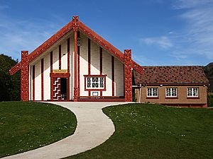
The total population of the peninsula is less than 10,000 people. About half of them live in the Dunedin suburbs that extend onto its western end, like Vauxhall and Shiel Hill. Along the harbour side, there are several small communities. The largest are Macandrew Bay (with about 1,100 people), Portobello, and Otakou. Otakou was the first permanent European settlement on the harbour and had an early whaling station.
History of Otago Peninsula
Early Māori Settlement
Experts believe that the first people arrived in New Zealand around 1300 AD. They settled mostly on the east coast of the South Island. During these early times, the Otago Peninsula was a very busy area, home to many people.
Many ancient Māori sites have been found on the Otago Peninsula. These sites show that people lived here permanently, not just in temporary camps. The early settlers were Polynesian people, ancestors of today's Māori. They hunted large birds, especially the now-extinct moa, and also seals, and they fished.
As time went on, the moa became harder to find. A new Māori culture developed, known as Classic Māori. People started building pa (fortified villages). New groups of people also arrived on the Otago Peninsula. People here began to rely more on gathering food, especially the root of the cabbage tree. Many old ovens used for cooking cabbage tree roots can still be seen on the peninsula, showing how much the land was used.
The Kati Mamoe people arrived in the late 1500s, followed by the Kai Tahu people about 100 years later. Pukekura, a strong fortress on Taiaroa Head, was built around 1650. Its old terraces can still be seen today.
Many stories from this time tell about important figures like Waitai and Moki II, who both lived at Pukekura pa. One famous story is about Tarewai, a Kai Tahu warrior. He took control of Pukekura and had a conflict with the Kati Mamoe people at Papanui Inlet. He made a famous escape back to Pukekura by jumping off a cliff, which is still called Tarewai's Leap.
European Arrival and Whaling
James Cook sailed past the coast in 1770 and named Cape Saunders. Sealers started using the harbour around 1808. The Weller brothers set up a large whaling station at Wellers Rock (modern Otakou) in 1831. This station grew to be the biggest in New Zealand, and Otago Harbour became a busy international whaling port.
However, whaling declined by 1839. In 1840, the Treaty of Waitangi was signed on the peninsula. In 1844, Māori set aside land at the Heads when they sold the Otago Block for a new Scottish settlement. When the first ships of settlers arrived in 1848, the main settlement moved to Dunedin. Port Chalmers, on the other side of the harbour, became the new international port. The old whaling village became known as 'Otakou'.
Modern Growth and Changes
As Dunedin grew, the southern end of the peninsula became a city park and then a suburb. Much of the native bush was cleared to make way for farms and settlements.
During the Otago Gold Rush in the 1860s, fun gardens were created at Vauxhall. Rich settlers built large homes like Glenfalloch and Larnach Castle. A lighthouse was built at Taiaroa Head in 1864. Prisoners, including Māori prisoners of war, helped build the winding road along the harbour, with its unique stone seawalls. Farmers also built dry stone walls across the land, similar to those in Scotland.
The land was used for mixed farming, and later focused on dairy farming. New Zealand's first dairy co-operative started here in 1871. In the 1880s, because people worried about a Russian invasion, Taiaroa Head was heavily fortified. A special "disappearing gun" was installed in 1886. Ferries connected the peninsula's harbour coast with Dunedin and Port Chalmers.
In 1904, a marine fish hatchery was built at Portobello. In the 1920s, the royal albatross colony started at Taiaroa Head on its own. People then began to protect it carefully because it was so scientifically interesting.
In the 20th century, farming changed. The population in rural areas, especially on the Pacific coast, decreased. Many old farm buildings and roads were left to decay. This gave the landscape a unique, natural look, which attracted visitors and artists.
After World War 2, the soldiers left Taiaroa Head, and the lighthouse became automated. The University of Otago took over the fish hatchery for research. In 1967, Dunedin City took over the peninsula's local government.
In recent years, more people have moved to the peninsula's towns. There are also more "lifestyle" properties on the harbour slopes and a growing number of tourists. The Otago Peninsula is special because you can see signs of human history everywhere, alongside its beautiful natural environment.
Natural History of Otago Peninsula
The Otago Peninsula is home to many unique, rare, and endangered animals and plants, both on land and in the sea. For example, Jewelled geckos live here. In the past, even giant moa were seen on the peninsula. Large ocean animals like basking sharks, great white sharks, and leatherback turtles have also been seen along the Otago coast.
Oceanic Birds
The peninsula has a wide variety of birds. You can find the endangered yellow-eyed penguin, little blue penguin, shags, and the royal albatross. As mentioned, Taiaroa Head is the only place in the world where royal albatross nest on a mainland near people. Many wading birds, like royal spoonbills, are often seen around Hooper's Inlet and Papanui Inlet on the Pacific coast.
Marine Mammals
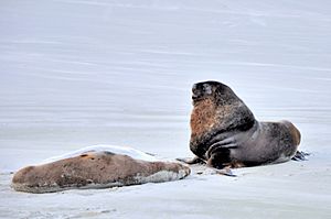
The coasts of the Otago Peninsula are important places for marine mammals. Seal and sea lion populations have grown back in the 20th century after being hunted almost to extinction in the 1800s. Many New Zealand fur seals and Hooker's sea lions now breed around Taiaroa Head. The Otago Peninsula is a special place for sea lions because it's the only continuous breeding ground on a main inhabited island. You might also see Southern elephant seals and leopard seals here.
The Otago Peninsula is also one of the best places on the mainland to see Southern right whales. Historically, they came into Otago Harbour to breed. They were hunted a lot, but their numbers are slowly recovering, and more whales are being seen. While they rarely enter the harbour now due to ship traffic, you can sometimes see them off the coast during their winter migration. Humpback whales are also seen. Other large whales like blue whales and Minke whales have been confirmed in the area.
Several types of dolphins and small whales live around the peninsula. Dusky dolphins and the endangered Hector's dolphins are often seen here. Bottlenose dolphins and common dolphins appear less often. The outer peninsula, near Taiaroa Head, is one of the main gathering spots for dusky dolphins in New Zealand. Orca are also seen sometimes. Further offshore, about 20 kilometres from the coast, there's a deep sea canyon where other oceanic species like sperm whales and pilot whales can be found.
Tourist Attractions
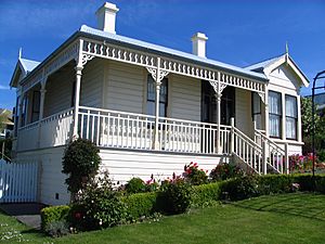
- Fletcher House, an Edwardian cottage museum in Broad Bay.
- Otago Peninsula Museum & Historical Society Museum, which tells the story of the peninsula's history, in Portobello.
- Glenfalloch Woodland Gardens & Cafe, beautiful gardens to explore.
- Larnach Castle, New Zealand's only castle.
- Royal Albatross Colony - only mainland colony of albatross in the world, where you can see the amazing royal albatross.
- The Dunedin City Council owns 328 hectares of land around Harbour Cone. This area has old settler sites and native bush. There are many walks to enjoy here. You can find more information on the Dunedin City Council's website.
- A popular walking and cycling track (part of the Otago Harbour Cycleway) runs from Dunedin city along the harbour shore to Portobello. All roads on the peninsula that cars can use are also open to cyclists and walkers.
See also
 In Spanish: Península de Otago para niños
 | Victor J. Glover |
 | Yvonne Cagle |
 | Jeanette Epps |
 | Bernard A. Harris Jr. |


