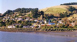
Macandrew Bay facts for kids
Quick facts for kids
Macandrew Bay
|
|
|---|---|
|
Suburb
|
|

Macandrew Bay
|
|
| Country | New Zealand |
| Local authority | Dunedin |
| Area | |
| • Land | 258 ha (638 acre) |
| Population
(June 2023)
|
|
| • Total | 1,630 |
|
|
||
Macandrew Bay (Māori: Te Roto Pāteke) is a small community in the South Island of New Zealand. It is located on the beautiful Otago Peninsula, right by the water of Otago Harbour.
The bay is named after James Macandrew. He was a Scottish settler who lived here later in his life. The Māori name for the bay is Te Roto Pāteke. This name refers to the Brown teal, a type of duck. These ducks, called Pāteke in Māori, used to be common in the area. Early European settlers called the bay "The Hundreds." This was because of the many large rocks covering the shoreline.
Macandrew Bay is part of Dunedin city. However, it feels like its own small town by the coast. Even though Dunedin's city centre is only 10 kilometres away, Macandrew Bay feels separate. It's a place where people live and travel to work in the city. It's also a peaceful spot to relax by the harbour.
Contents
Exploring Macandrew Bay
The main part of Macandrew Bay is where Portobello Road and Greenacres Street meet. Greenacres Street is a narrow road that goes steeply up the Otago Peninsula. It follows a small stream called Rodgers Creek.
The community hall is on Greenacres Street, close to Portobello Road. The few shops in the area are just southwest of this junction. Behind these shops, you'll find the local primary school and a cemetery. James Macandrew's grave is located in this cemetery.
The Beach and Park
Macandrew Bay has a small beach right across from the shops. It's a popular spot for people to visit. The beach was actually made by people. Sand was brought here from the nearby Pacific Ocean coast.
The area around the beach has been turned into a public park. The landscaping for this park was finished in 1979. It's a great place for families to enjoy the outdoors.
Nearby Communities
Macandrew Bay is the largest of several small communities along the harbour side of the Otago Peninsula. Just before Macandrew Bay, coming from Dunedin, you'll find Glenfalloch Gardens. These are beautiful private gardens that are open to the public.
Beyond Macandrew Bay to the northeast are Company Bay and Raynbirds Bay. To the southwest is Colinswood, named after James Macandrew's house. These small places can be thought of as tiny "suburbs" of Macandrew Bay. Further past Raynbirds Bay are Broad Bay and Portobello.
All these communities are connected by Portobello Road. This road winds along the harbour coast of the peninsula. There's also the Otago Harbour Cycleway, a path for bikes that runs next to the road. Both the road and the sea wall along the harbour were built by prisoners in the 1860s.
Another road, Castlewood Road, goes up from Company Bay. It connects to Highcliff Road, which runs along the top ridge of the peninsula. Castlewood Road also links to Camp Road. This road leads to the famous Larnach Castle, which sits high above Broad Bay.
People of Macandrew Bay
The Macandrew Bay-Company Bay area covers about 2.58 square kilometres. In 2018, about 1,572 people lived here. This was a small increase from previous years.
There were 621 homes in the area. The population included slightly more females than males. The average age was 46.8 years. About 20% of the people were under 15 years old.
Most people in Macandrew Bay are of European background (93.3%). About 7.1% identify as Māori. Other groups include Pasifika, Asian, and other ethnicities. Many people in the area (55.7%) said they had no religion. About 34.7% were Christian.
Education in Macandrew Bay
Macandrew Bay School is a primary school for children from Year 1 to Year 6. It is a state school, meaning it is funded by the government. The school has about 132 students. Macandrew Bay School first opened its doors in 1859.
 | Roy Wilkins |
 | John Lewis |
 | Linda Carol Brown |


