Papanui Inlet facts for kids
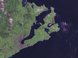
Papanui Inlet is a beautiful natural harbour located on the Pacific Ocean coast of the Otago Peninsula in the South Island of New Zealand. It is one of two large inlets in this area, known for its stunning scenery and important wildlife.
Contents
What's in a Name?
The name Papanui comes from the Māori language. It means "large plain." The word papa means flat land, and nui means big. This name first described the flat, sandy areas and mudflats just north of the inlet. Later, when Europeans settled on the peninsula, the name was used for the inlet itself. The Māori people also knew this inlet by another name: Makahoe.
Exploring Papanui Inlet
Papanui Inlet is famous for its many different kinds of birds. It is very close to another inlet called Hoopers Inlet, which also has lots of bird life. The inlet is about 3 kilometres (2 miles) east of a small town called Portobello.
You can easily reach Papanui Inlet by road from Portobello. It's also just 18 kilometres (11 miles) west of Dunedin, a larger city that Papanui Inlet is part of. Both Papanui Inlet and Hoopers Inlet are quite shallow. When the tide is low, they become mostly sand and mud flats.
Inlet's Connection to the Ocean
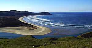
The mouth of Papanui Inlet opens directly into the Pacific Ocean on its eastern side. The southern side of the inlet has steep hills. However, the northern side is mostly flat land called Okia Flat. A large part of this flat area is protected as the Okia Reserve.
Beyond Okia Flat is Wickliffe Bay, which borders Victory Beach. This is the longest beach on the Otago Peninsula. The flat land makes the inlet's mouth quite narrow.
Shipwreck History
If you visit at low tide, you might still see parts of the SS Victory shipwreck near the inlet's mouth. This ship sank in 1861, and the beach is named after it. Both the shipwreck and an old Māori site called a midden (where ancient people left their food waste) are important historical places. They are protected as Category II historic sites by Heritage New Zealand.
Nearby Landmarks
Papanui Inlet is separated from Hoopers Inlet by a strip of land. This land forms a narrow connection to a hilly area that includes Cape Saunders. This cape is a significant landmark. The highest point on the Otago Peninsula, Mount Charles, is also in this area. Mount Charles stands 408 metres (1,339 feet) tall. A road that leads to Cape Saunders runs along the southern shore of Papanui Inlet.
Protecting the Inlet
The Otago Regional Council has officially registered Papanui Inlet as a Coastal Protection Area. This means it is a special place that needs to be looked after. It is important for several reasons:
- It has cultural and spiritual value to the Kai Tahu iwi (a Māori tribe).
- It is a vital home for many birds and sea creatures.
- It contains important historical sites, like the shipwreck and the midden.
 | Misty Copeland |
 | Raven Wilkinson |
 | Debra Austin |
 | Aesha Ash |


