
Northcote, Auckland facts for kids
Quick facts for kids
Northcote
|
|
|---|---|
|
Suburb
|
|

Northcote Point Ferry Terminal, The Wharf events centre, and Little Shoal Bay
|
|

Northcote
Location in New Zealand
|
|
| Country | New Zealand |
| Local authority | Auckland |
| Electoral ward | North Shore ward |
| Local board | Kaipātiki Local Board |
| Area | |
| • Land | 528 ha (1,305 acre) |
| Population
(June 2023)
|
|
| • Total | 11,980 |
| Postcode(s) |
0627
|
| Ferry terminal(s) | Northcote Point Ferry Terminal |
|
|
||
Northcote (also known as Māori: Te Onewa) is a suburb in Auckland, New Zealand. It's located on the North Shore, right by the Waitematā Harbour. It's about 4 kilometers northwest of the Auckland City Centre.
Northcote includes two main areas: Northcote Point and Northcote Central. Northcote Point is a peninsula where the Auckland Harbour Bridge begins. Northcote Central is the main shopping and business area. The suburb also has two special volcanic craters called maars.
Māori people first settled in Northcote around the 13th or 14th centuries. They built a fort called Te Onewa Pā to protect their communities. European settlers arrived in the 1840s, and a town grew around the ferry terminal. Early jobs included making bricks, working with sulfur, and growing fruit. By the 1880s, Northcote's beaches were popular. In 1908, Northcote became a borough, which meant it had its own local government.
When the Auckland Harbour Bridge opened in 1959, Northcote Central grew quickly. However, Northcote Point became quieter. In 1989, Northcote joined North Shore City, and then in 2010, it became part of the larger Auckland "super city." Recently, Northcote has been working on new housing and improving its urban areas.
Contents
What's in a Name?
Northcote is named after a British politician, Stafford Northcote, 1st Earl of Iddesleigh. A local resident, Major Benton, suggested the name in 1880. Before that, the peninsula was called Rough Point in 1841. It was later renamed Stokes Point in 1848, after Captain John Lort Stokes. The name Stokes Point is still used for the southern tip of the peninsula today.
Land and Nature


The land in Northcote is mostly made of sandstone, formed from the seabed millions of years ago. Northcote has two volcanic craters: Tank Farm (also called Tuff Crater or Te Kōpua ō Matakamokamo) and Onepoto (also called Te Kōpua ō Matakerepo). Scientists believe these craters erupted about 180,000 to 190,000 years ago.
Before people arrived, the North Shore was covered in thick forests. Smiths Bush in Onewa Domain is a small part of this original forest. It has tall kahikatea and taraire trees.
Where is Northcote?
Northcote has two main parts: Northcote Central (the northern part) and Northcote Point (the peninsula to the south). The suburb is bordered by roads like Ocean View Road and Northcote Road. It's also next to the Auckland Northern Motorway and Shoal Bay.
The highest point in Northcote is an 88-meter hill on Pupuke Road. This hill is home to the Pupuke Road Reservoir and Pump Station. The very southern tip of Northcote Point is called Stokes Point.
The Onepoto Stream flows through Northcote and into Shoal Bay. Another stream, Hillcrest Creek, also flows east into Shoal Bay. A long time ago, the upper parts of Hillcrest Creek were swampy. A traditional Māori name for Hillcrest Creek is Wakatatere, which means "The Drifting Canoe."
Two beaches, City of Cork Beach and Sulphur Beach, used to be in Northcote. But they were covered over in the 1950s to build the Auckland Northern Motorway. Little Shoal Bay is to the west of Northcote Point and has a beach called Halls Beach.
Northcote's Past
Māori History
.jpg)
Māori people first settled in the Auckland Region around the 13th or 14th centuries. The Tainui canoe, an important traditional boat, visited Northcote. The Shoal Bay area was good for gathering shellfish. The rich volcanic soil in Northcote was perfect for growing kūmara (sweet potatoes).
The North Shore was home to Tāmaki Māori tribes. Later, a warrior named Maki united many of these tribes to form Te Kawerau ā Maki. After Maki, his children settled different areas. His daughter Kahu is the namesake of the North Shore, which is called Te Whenua Roa o Kahu ("The Greater Lands of Kahu").
The Story of the Craters
Northcote is part of a Ngāi Tai ki Tāmaki traditional story called Te Riri a Mataaho ("The Wrath of Mataaho"). This story explains how the two volcanic craters, Te Kōpua ō Matakamokamo and Te Kōpua ō Matakerepo, were formed.
The story tells of two children of the Fire God Mataaho, Matakamokamo and his wife Matakerepo. They argued so much that their fire went out. Matakamokamo blamed the Fire Goddess, Mahuika. Mahuika was angry and asked Mataaho to punish them. Mataaho destroyed their home, creating Lake Pupuke and Rangitoto. The couple fled, but Mataaho continued to punish them. He turned them into stone, forming the two volcanic craters we see today.
Te Onewa Pā: A Fort on the Headland
Te Onewa Pā was a fortified village located on the Stokes Point headland. The name Onewa refers to the ditch that separated the fort from the mainland. This pā was very important because of its great view over the Waitematā Harbour. It also protected fishing areas and kūmara gardens.
Over the years, Te Onewa Pā was attacked many times by different tribes. In the early 1820s, most Māori left the North Shore due to conflicts during the Musket Wars. Te Onewa Pā was left empty for a while. Some Māori returned in the 1830s and lived there until the mid-1850s.
Early European Settlers

.jpg)
The Northcote area was bought by the government in 1841. The first European family, the Callans, settled there in 1843. Phillip Callan started a brickyard at Sulphur Beach. Other settlers soon followed, many from Hokianga. Early businesses included a soap and candle factory, timber milling, and kauri gum digging.
In 1848, the Catholic Church bought land in Northcote. They built St Mary's School and the Awataha Catholic Mission. This school, opened in 1851, taught both Māori and Pākehā students.
A ferry service to Northcote began in 1854, which helped the area grow. In 1859, Philip Callan built the Northcote Tavern. This hotel became a key meeting place and a stop for people traveling north. The first regular ferry from Northcote Wharf started in 1860. St John's Anglican Church, built soon after, is the oldest existing building on the North Shore.
In 1878, the Auckland Chemical Works opened in Northcote. It processed sulfur, but it wasn't very successful.
Growing as a Suburb
Between 1880 and 1910, Northcote grew with many new houses. Northcote Point became a popular place for people who worked in Auckland to live, thanks to the ferry. Wealthy Aucklanders also built homes here. Hall's Beach and Sulphur Beach became popular for picnics.
Northcote was also known for growing fruit, like strawberries, peas, and cucumbers. In 1886, a fruit-growing association was formed. Farms in Northcote also supplied milk to Auckland.
In 1891, the Catholic Mission allowed Māori, including some from Te Kawerau ā Maki, to resettle church lands at Awataha. This community lived on the northern shores of Tank Farm. Later, these lands were leased out, and the Māori community faced eviction. Their meeting house was torn down in 1920.
Becoming a Borough
.jpg)
_(cropped).jpg)
In 1908, Northcote had grown enough to become a borough. This meant it had its own council and mayor. To celebrate, Stokes Point was made a public reserve. A tall flagstaff was put up, and a special tōtara tree was planted, named Tainui by local Māori.
In the 1920s, Northcote continued to grow, especially around Queen Street near the ferry terminal. A new cinema, the Onewa Picture Drome (later called Bridgeway), opened in 1927. The gas works at Little Shoal Bay became the biggest employer in Northcote.
During World War II in 1942, the United States Army built large fuel storage tanks at the northern volcanic crater, which is why it's now called Tank Farm. Sadly, a Māori cemetery (urupā) was removed during this construction.
In the 1950s, new state houses were built in central Northcote. The Northcote War Memorial Library opened in 1956, funded by local events and government grants.
The Auckland Harbour Bridge Changes Everything
.jpg)
People had talked about building a bridge across the Waitematā Harbour since the 1860s. Construction of the Auckland Harbour Bridge in Northcote began in the mid-1950s.
Building the bridge and the Auckland Northern Motorway changed the area a lot. Much of Te Onewa Pā on Stokes Point was destroyed to make way for the bridge. The beaches on the eastern coast were covered to build the motorway. The Onepoto Basin, which used to be open to the harbor, was drained and turned into parks in the 1960s.
The harbour bridge officially opened on May 30, 1959. The Northcote Shopping Centre opened soon after, making northern Northcote the new main business area. While Northcote Central grew, Northcote Point became quieter. The ferry service stopped, shops closed, and Queen Street became a less busy road.
Recent Changes and Future Plans

In 1966, the North Shore Teachers College moved to Northcote. In 1971, a seafood restaurant called Fisherman's Wharf opened near the Northcote wharf. This building is now an events center called The Wharf.
In 1989, Northcote Borough became part of North Shore City. By the 1990s, more Asian communities began to live in Northcote. In the 2000s, the Chinese New Zealander community started holding yearly Chinese New Year parades.
The former Smale family farm was turned into Smales Farm, a business complex. The Akoranga Business Park also developed nearby.
Northcote is now part of a plan to build more homes and improve the area. About 1,700 new homes are planned for the 2020s. There's also a project called Te Ara Awataha. This project will create new parks, plant native trees, and bring the Awataha Stream back to the surface. The stream had been put underground in pipes in the 1950s.
People of Northcote
Northcote covers about 5.28 square kilometers and has an estimated population of about 11,541 people.
In the 2023 census, 62.9% of people identified as European (Pākehā). Other groups included 9.1% Māori, 7.0% Pasifika, and 28.5% Asian. Most people (92.4%) spoke English. About 41.1% of people were born overseas.
Many people in Northcote have higher education. About 41.8% of people aged 15 or older have a bachelor's degree or higher.
Places to Visit
.jpg)
- The Northcote Shopping Centre is the main commercial area. It has a Woolworths supermarket.
- Smiths Bush in the Onewa Domain is a special native forest. It was saved from being cut down by its owners, James and Catherine Smith. A large part of the forest was cut down in 1959 to build the motorway.
- Northart is an art gallery and community center in Northcote. It shows art from artists on the North Shore.
- Kauri Glen is a steep area of native bush that was protected in 1907.
- The Northcote Tavern was first built in the 1850s. The original building burned down and was rebuilt in 1888.
- St John the Baptist (Anglican Church) is an old church in the area.
- Stokes Point Reserve is where Te Onewa Pā used to be. It became a public reserve in 1908. In 2015, the reserve was redeveloped to celebrate its history.
Famous People
- George Graham, a New Zealand ethnographer (someone who studies cultures), lived at Northcote Point in the early 1900s.
Schools in Northcote

The first school in Northcote was Stokes Point School, started in 1873. It was located where Northcote College is today.
- Northcote College is a high school for students in years 9–13.
- Northcote Intermediate is for students in years 7–8. It celebrated its 50th anniversary in 2008.
- Onepoto School is a primary school for years 1–6. It shares a site with Northcote Intermediate.
- Northcote Primary School is a primary school for years 1–6. It opened at its current location in 1918. The Northcote war memorial is in front of the school.
- St Mary's School is a Catholic primary school for boys and girls in years 1–6, and for girls only in years 7–8. It celebrated its 75th anniversary in 2008.
Auckland University of Technology has its North Campus on Akoranga Drive.
Hato Petera College was a Catholic Māori high school. It offered boarding for students until 2016 and closed in 2018.
Sports and Fun
Northcote is home to two rugby clubs:
- The Northcote Tigers rugby league club, started in 1910.
- The Northcote and Birkenhead Rugby Union Club, started in 1929.
Getting Around Northcote
Northcote is right next to the Auckland Northern Motorway. Fullers Group ferries also stop at Northcote Point, close to the Auckland Harbour Bridge.
In 2000, a bus station for the Northern Busway was planned for Northcote. However, this plan was canceled after residents expressed concerns about increased traffic.
Images for kids
-
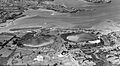
Tank Farm and Onepoto (pictured in 1957) are two volcanic maars in Northcote, estimated to have erupted between 190,000 and 180,000 years ago
