
Second Harbour Crossing, Auckland facts for kids

The Second Harbour Crossing is a plan for a new way to cross the Waitematā Harbour in Auckland, New Zealand. Planners also call it the Additional Waitematā Harbour Crossing (AWHC) or the Waitematā Harbour Connections (WHC).
Auckland is a very big city, and about a third of New Zealand's people live there. The harbour splits the city, separating the main city centre (CBD) from the North Shore. The current Auckland Harbour Bridge was built in 1959. Even though it was made wider in 1969, it often gets very busy, especially during rush hour.
This bridge is a key part of New Zealand's main road network. It carries both national traffic and local cars. When the bridge is busy or closed due to accidents or bad weather, traffic can get stuck easily. This causes big traffic jams in Auckland, which also affects the economy.
For many years, people have suggested building new ways to cross the harbour. In 2023, the Labour government had plans for two new road tunnels and one light rail tunnel. Construction was planned to start in 2029. However, after the 2023 election, the new National-led government is reviewing these plans.
Contents
Why a New Crossing is Needed

People have thought about building a crossing over Waitematā Harbour for a long time. Ideas first came up soon after Auckland was founded in 1840. In 1860, someone designed a floating bridge for farmers to bring their animals into the city. It was too expensive then. Later, in the 1920s, people even suggested a tunnel for trains.
In 1946, a special group suggested a four-lane road bridge. But they soon realised that more people would move to the North Shore once it was connected. So, a bigger bridge with at least six lanes would be needed.
The Auckland Harbour Authority was set up in 1951 to help get money and plans for the bridge. They decided on a five-lane bridge with paths for walking and cycling. But the government said the cost could not be more than $5 million. This meant they built a simpler, four-lane bridge without paths for people or bikes. Construction started in 1954, and the bridge opened in 1959. People had to pay a toll to cross until 1984.
The Current Bridge Gets Busy
Right from the start, more cars used the bridge than expected. By 1969, it was clear the bridge was too small. Four extra lanes, called "Nippon clip-ons," were added to each side. This made it an eight-lane bridge. At the time, experts thought this would be enough until about 1985.
But even with the extra lanes, the bridge quickly became busy again during rush hours. Soon, people started talking about a second bridge. One idea was to connect Meola Reef to Birkenhead, but this plan was dropped in the 1970s.
Traffic studies have always shown that congestion would get worse as Auckland grew. The North Shore is now a busy urban area, very different from when the first bridge was built. Having only one main crossing is also a problem because New Zealand has earthquakes and volcanoes. If the bridge was damaged, it would be a big issue for the whole country.
However, building a new crossing is very expensive. It also causes a lot of disruption to communities during construction. These reasons have often stopped governments from starting a new project.
Other Solutions and Public Transport
Instead of a new crossing, planners have tried shorter-term solutions. For example, Auckland Council's 2011 transport plan suggested focusing on projects that could delay the need for a second crossing. One big project was the Western Ring Route. This is a series of upgraded and new motorways that go around the western side of the harbour. It helps traffic travelling between the North Shore and West Auckland. This route was finished in 2017.
Some people who don't want a new crossing point out that the number of cars crossing the bridge during peak times hasn't changed much since the 1990s. This is because the roads leading to the bridge are also full. Instead, new journeys have been made possible by improving public transport.
The Northern Busway has been very successful. Now, 50% of people crossing the bridge during peak times use buses. However, there are not many more ways to increase capacity on the current bridge. By 2017, Auckland Transport predicted the Northern Busway would be full by 2026. To carry more passengers, the busway would need to become a light rail line. But the current bridge is too old and heavy for light rail. A new crossing is needed for this.
Also, the number of trucks crossing the bridge is expected to more than double by the middle of the century. This shows how important a new crossing is for New Zealand's economy.
The original bridge also doesn't have paths for walking or cycling. While ferries cross the harbour, they can be slow and expensive. This stops many Aucklanders from walking or cycling, which could help reduce road traffic. Auckland Transport's plan from 2022 confirmed that a new crossing with paths for walking and cycling is very important for the future.
Modern Ideas for a New Crossing
1996 Report and Early Studies
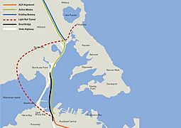
In 1996, a study looked at options for a new crossing. It suggested either a new bridge west of the current one, connecting to a tunnel under Ponsonby, or a tunnel east of the bridge connecting to the Central Motorway Junction. If both were built, they would have cost about $4.5 billion in today's money.
From 2006 to 2009, more studies were done. They looked at a tunnel under the Western Reclamation (now called the Wynyard Quarter). This was estimated to cost NZ$3 billion. Other ideas, like a tunnel between Mechanics Bay and Northcote, were also considered but faced problems.
In 2008, a plan called "option 2C" was published. It involved two new crossings, each with two tunnels. One would be parallel to the existing bridge. The second would go diagonally southeast from the North Shore to Grafton Gully, east of the CBD. This second option would need to be a tunnel because it would cross shipping lanes.
Local groups had different ideas. North Shore City preferred a tunnel because it looked better and could be used for light rail later. Many people thought the new crossing should be for public transport only, possibly connecting to Waitematā Station (formerly Britomart).
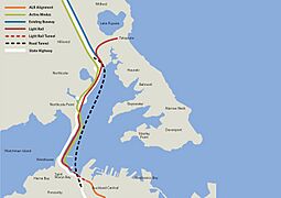
In 2008, a private group suggested four separate tunnels: two for cars and two for public transport. This plan would have cost between NZ$3.7 and NZ$4.1 billion. They predicted it would increase journeys across the harbour by 80% by 2041, with 30% by public transport.
In 2009, Waka Kotahi NZ Transport Agency (NZTA) protected the route for the four-tunnel option. This meant future building in the Wynyard Quarter would not block the tunnel path. However, no money was set aside for construction at that time.
2007 "Anzac Centenary Bridge" Idea
In 2007, some politicians and architects suggested building a much larger new bridge east of the existing one, and then taking down the old bridge. This new bridge would be ready for the 100-year anniversary of the Gallipoli landings in 1915.
The new bridge would be about 50% longer and have three times the capacity. It would include lanes for light rail, cyclists, pedestrians, cars, and buses. Supporters said it would pay for itself by freeing up land for development in areas like Saint Mary's Bay. They also said a bridge would be cheaper to run than a tunnel and wouldn't need air vents.
In 2009, the bridge idea came up again. But critics said it would cost too much and take money from other important transport projects. Most local mayors at the time preferred the tunnel option.
A more detailed plan for the bridge in late 2009 included eight traffic lanes, two light rail tracks, and walking/cycling paths. Its estimated cost was NZ$2–3 billion, which was thought to be cheaper than the tunnel plans. NZTA said they would protect the tunnel routes but didn't rule out a future bridge. The group supporting the centenary bridge later stopped their efforts.
2010 Study and "Skypath"
In 2010, another study for a second crossing was announced. The final report suggested three new crossings: a bridge, a road tunnel, and a heavy rail tunnel, costing a total of $6 billion. The new bridge would have included bike lanes that people would pay to use.
In 2011, NZTA suggested a simpler idea called "Skypath." This plan was to add new paths for walking and cycling onto the existing bridge. It was popular at first, and permission was granted in 2016. The Labour government elected in 2017 also promised to fund it.
However, adding weight to the old bridge's supports was complicated. In 2019, the plan changed to have Skypath run beneath the bridge on its own supports. But the cost grew to an estimated $785 million. In 2021, the plan was cancelled because it was decided it would be better to build a completely new crossing instead.
Some local groups still want one of the existing bridge's lanes to be used for cycling. They believe this would encourage more people to cycle instead of drive, helping with traffic. But NZTA has said no, because of safety risks for cyclists and pedestrians from nearby traffic.
2023 Waitematā Harbour Connections Ideas
In 2019, NZTA asked a company called PwC to look at many options for a second crossing. They noted that 170,000 vehicles crossed the bridge every day, including 11,000 trucks and over 1,000 buses. While car numbers during peak times had stayed the same, bus and truck journeys kept growing. They predicted 26,000 truck crossings by 2046. The report suggested that new heavy rail tunnels for cargo and passengers would be more efficient than previous road-plus-rail ideas.
-
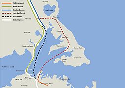
Option 1
-
Option 2
-
Option 3
-
Option 4
-
Option 5


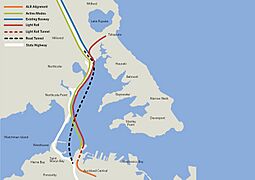
In March 2023, Transport Minister Michael Wood announced five new options for "Waitematā Harbour Connections." These options included different mixes of tunnels, bridges, and transport types. All of them were designed to connect with the planned Auckland Light Rail route.
- Option 1: Two new tunnels. One for light rail from Wynyard Quarter to Smales Farm, and one for State Highway 1 from Saint Mary's Bay to Akoranga Drive. The existing bridge would get more bus lanes and new paths for walking/cycling. Cost: $25 billion, 15 years to build.
- Option 2: One new bridge next to the existing one. It would have lanes for cars, buses, walking/cycling, and a light rail line. Cost: $15 billion, 10 years to build. This was the cheapest but also the least strong option.
- Option 3: One new bridge, one new tunnel. A new light rail line in the tunnel. The new bridge would carry cars and walking/cycling paths for through traffic. Local traffic would use the existing bridge. 10 years to build, but not very efficient for increasing total capacity.
- Option 4: One new bridge, one new tunnel. A new bridge east of the existing one for walking/cycling and light rail. A new road tunnel for Highway 1. 15 years to build, considered very efficient.
- Option 5: Similar to option four, but the new bridge would start at the Wynyard Quarter. 15 years to build, also considered very efficient.
.png)
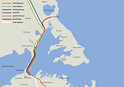
In August 2023, Transport Minister David Parker and Prime Minister Chris Hipkins announced a "Preferred Option" that combined parts of the earlier ideas:
- A tunnel for Auckland Light Rail, going from Wynyard Quarter to Belmont on the North Shore, then north to Albany.
- Two new road tunnels (one for each direction) connecting the Central Motorway Junction directly to the North Shore. This would let national traffic bypass the CBD. The existing Harbour Bridge would be for local traffic.
- Improvements to existing bus stations on the Northern Busway.
- Major upgrades to the existing Harbour Bridge. State Highway 1 from the bridge to Akoranga would be raised to protect it from rising sea levels.
- The Northern Busway would be extended across the existing bridge to the CBD using two dedicated lanes. The eastern "clip-ons" would become a separate path for walking and cycling, leaving four lanes for general traffic.
The total cost was estimated to be between $35 billion and $45 billion. This would make it the most expensive infrastructure project in New Zealand's history.
People had mixed reactions. The Green Party, who were partners with Labour, were disappointed that the plan focused on roads instead of just public transport. Others, like Auckland Mayor Wayne Brown, thought it was too expensive and unrealistic, especially with an election coming up. The National party leader, Christopher Luxon, supported the idea generally but had concerns about the cost and timeline.
After the National party won the 2023 election, they announced that Auckland Light Rail would be cancelled. Its budget of $14.6 billion would be used for road and highway upgrades across New Zealand, including new busways in Auckland. The proposed road tunnels under the harbour were still being considered.
By December 2023, after reviewing the plans, the Ministry of Transport, Auckland Transport, and Auckland City Council all noted that the plans had "significant value-for-money issues." Local planners also said that without more money from the government, their only options for transport in Auckland were new cycle lanes or continued upgrades to the Northern Busway. The head of Waka Kotahi NZTA, Nicole Rosie, said that the planning process for the Waitematā Harbour Connections had been slow. She noted that they were making the same decisions that could have been made seven to ten years ago. In the meantime, the population has grown, the problem has become more urgent, and the costs have gone up.
See also
- General
- Public transport in Auckland
- Transport in Auckland
- North Shore Line, New Zealand
- Specific
- Central Motorway Junction, a major motorway connection southeast of the bridge
- Newmarket Viaduct, another important traffic bottleneck in Auckland
- Western Reclamation, a large area east of the bridge, a possible location for a second crossing
