Grafton Gully facts for kids

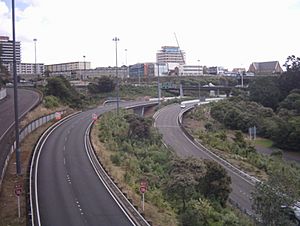
Grafton Gully is a very deep and wide natural valley in Auckland, New Zealand. It runs north towards the sea, cutting through the city's volcanic hills. This gully acts like a natural border, separating Auckland's main business area (the CBD) from the nearby suburbs of Grafton and Parnell to the east. It is about 50 meters deep and 100 meters wide.
How Grafton Gully Got Its Name
The gully is named after the suburb of Grafton. This suburb was named after one of New Zealand's early Governors, Robert FitzRoy. His grandfather was the third Duke of Grafton. The suburb grew next to the Government Domain and Hospital. Over time, the valley next to it became known as Grafton Gully. For many years, some people also called it Cemetery Gully because the Symonds Street Cemetery is located on its western side.
What You'll Find in the Gully
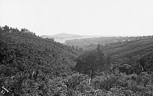
Grafton Gully is a unique part of central Auckland. Because its sides are very steep, it has mostly avoided being covered by buildings or sports fields. However, before the motorway was built, a sports area called Blandford Park was located here until the mid-1960s.
Motorways and Cycleways
Today, much of the gully is still covered with natural bush. But at the bottom of the gully, you'll find several lanes of State Highway 16. This motorway helps cars travel into the city and towards places like the Ports of Auckland. In 2003, about 34,000 vehicles used this part of the motorway every day.
The motorway project in Grafton Gully was built between 2001 and 2003. It cost about NZ$68 million.
In 2014, a special path for bikes and walkers was added. This path is called the Grafton Gully Cycleway. It extends the Northwestern Cycleway through the gully all the way to Beach Road. It also connects to the University of Auckland campus areas in the eastern part of the city.
 | James B. Knighten |
 | Azellia White |
 | Willa Brown |


