Newton, New Zealand facts for kids
Quick facts for kids Newton |
|
|---|---|

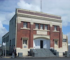
The former Orange Hall, a well-known Newton landmark.
|
|
| Basic information | |
| Local authority | Auckland Council |
| Population | 1,641 (2013) |
| Surrounds | |
| North | Freemans Bay |
| Northeast | Auckland CBD |
| East | Auckland CBD, Grafton |
| Southeast | Eden Terrace |
| South | Mount Eden |
| Southwest | Arch Hill, Kingsland |
| West | Arch Hill |
| Northwest | Ponsonby |
Newton is a small area in Auckland, New Zealand. It is managed by the Auckland Council. In 2013, about 1,641 people lived there.
Since the Central Motorway Junction was built between 1965 and 1975, Newton has been split into two parts. This made the area smaller and less connected. The northern part is around Karangahape Road. The southern part is near Newton Road and the top end of Symonds Street. Both Karangahape Road and Newton Road meet Symonds Street to the east. Newton Road also connects to Great North Road and Ponsonby Road in the west.
At the southern end of Symonds Street, you'll find the Symonds Street Shops. Here, Upper Symonds Street has two big intersections. One is with Newton Road and Khyber Pass Road. The other is with Mt Eden Road and New North Road.
Contents
Exploring Symonds Street
Symonds Street is named after Captain William Cornwallis Symonds (1810–1841). He was an officer in the British Army. Captain Symonds came to New Zealand in the early 1830s. He helped set up Auckland and was involved in signing the Treaty of Waitangi. He was a trusted helper for Governor William Hobson. He also served as a Police Magistrate and Deputy Surveyor.
In 1841, Captain Symonds explored the North Island with a scientist named Ernst Dieffenbach. Sadly, Captain Symonds died in a boating accident in Manukau Harbour in November 1841. His brother, John Jermyn Symonds, stayed in New Zealand. Symonds Street in Onehunga is named after John Jermyn Symonds.
Discovering Karangahape Road
Karangahape Road gets its name from the ridge it sits on. In the past, this ridge was called Te Ara o Karangahape. This means 'The Path of Karangahape'. The name might refer to a path taken to visit an important chief or mythical person named Hape. This person lived near the Manukau Harbour to the southwest.
From around 1900 to the early 1960s, Karangahape Road was Auckland's busiest shopping street. It had many clothing and shoe shops. There were also several large department stores. In the mid-20th century, Karangahape Road was a popular place to shop. It was especially busy on late nights because of the cinemas there.
Newton's Past: A Look Back
In the 1800s, the name Newton covered a slightly different area. It stretched from what is now Surrey Crescent to Eden Terrace. So, when you read about Newton from the past, it might be talking about a different part of the city. For example, the Newton Branch of the ASB bank was built in the 1880s. It was located at the Karangahape Road end of Ponsonby Road.
In 1861, Newton had its own voting district. It was bordered by the harbour and other Auckland districts. After Sir George Grey died in 1898, the northwestern part of Newton was renamed Grey Lynn. This left Newton as the area between Karangahape Road and Eden Terrace. Since the motorway was built in the 1960s, many people think of Karangahape Road as separate from Newton. They often use the name Newton for the area around Upper Symonds Street.
The Newton Post Office has always been on Karangahape Road. The first one opened in 1878. Its current building was built in 1973. Until 2011, there was another Post Office for Newton and Eden Terrace. It was known as the Upper Symonds Street Post Office.
Historically, the area had a reputation for being a bit rough. In the 1920s, a newspaper called it a "haunt of many of Auckland's best-known crooks." This was one reason the Ponsonby Police Barracks were built nearby. They were located on Ponsonby Road, close to Karangahape and Newton Roads. This was an important police base. It helped police quickly respond to any issues in Freemans Bay or Newton Gully.
The Star Hotel, at the corner of Karangahape and Newton Roads, was a place for workers' union meetings. Michael Joseph Savage, who later became a Prime Minister, gave some of his early speeches there.
Newton Gully was seen as a place with older housing and some crime. City planners decided to build the motorway through this area in the 1960s. They thought this would help improve the city. People would move to newer areas, and Auckland's traffic problems would get better. However, the motorways also hurt local businesses. The Symonds Street shopping area was badly affected. It used to be a main place for furniture shopping in Auckland. But after the motorway, many shops closed. Its business group stopped in 1976, but it has recently started up again in 2012.
After the motorway was built, Newton became less popular for living. Symonds Street and Newton Road became like motorway on-ramps. Many homes were turned into light industrial buildings or torn down for factories. But since the 1990s, this has changed. Many industrial buildings are now being turned back into homes. New apartment blocks are also being built.
Upper Symonds Street is home to three large churches. These include St Benedicts Roman Catholic Church, the Church of the Holy Sepulchre, and St David's Presbyterian Church. In the 1900s, this area also had big furniture stores. There were also entertainment places like the Orange Coronation Hall and a roller skating rink. The Lyric, Auckland's first purpose-built cinema, opened here in 1911. The famous El Matador restaurant was also here in the 1960s.
In the mid-1990s, much of the eastern part of the street was demolished. This was partly to make the road wider. Important buildings like the Lyric Theatre and the El Matador were lost. The Skycity Casino and Sky Tower were first planned for this empty land. But they were built elsewhere. The 'missing' part of the street has since been rebuilt.
Interesting Buildings to See
- John Andrews & Sons Building - 132 Upper Symonds Street. This building was once a car showroom from the late 1920s. It has a neoclassical style. It was designed by A. Sinclair O'Connor.
- Saint Benedict's Church, St Benedicts Street. This Catholic church is made of brick in the Flemish Gothic style. It was built in 1886. It replaced an earlier wooden church that burned down. Both churches were designed by Auckland architect Edward Mahoney. The original wooden church had a bell tower with a spire. The brick church was meant to have one too, but it was never built. This is the second most important Catholic Church in Auckland. It served as the main Cathedral when Saint Patrick's Cathedral was closed for repairs.
- Dominican Priory, South of the church is a brick Gothic presbytery. It was also designed by Mahoney. It is now home to a Dominican Order of Monks. Ahmed Zaoui lived here from 2004 to 2007.
- St Benedict's Convent and College, On the east side of St Benedicts Street, across from the church, is a two-story brick house. It was for an order of nuns (Sisters of St Joseph of the Sacred Heart). Next to it is an empty space used as a carpark. This was where the Edwardian St Benedicts School stood. The school closed in 1980. Its secondary part joined with Marcellin College in Royal Oak. Most of the school buildings were torn down. The school hall burned down in the late 1980s. It used to be an important place for dances and theatre groups.
- Freemasons Hall, St Benedicts Street. This is a large and impressive building from the 1920s. It is in the neo-classical style. The architects were Chilwell & Trevithick.
- The Stables. This 19th-century wooden building is covered in corrugated iron. It is at the end of Stable Lane. It was built as stables for the Winstone company. It's rare to find an old stable block like this in a city. It's even more interesting because it uses corrugated iron. The Auckland City Council has listed it as a heritage building. The Stables has been renovated as part of a new building complex called "Site Three".
- Site Three, St Benedicts Street. This is a modern building with offices and a cafe. It is known for its architecture. Urbis magazine called it "strikingly graceful."
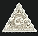
- Pigeon Post House. At the corner of Upper Queen St and Newton Road is a small old wooden house. It's one of the few original houses left in the area. This was the office for Mr. Holden Howie's pigeon post service to Great Barrier Island. This might have been the world's first regular air mail service, starting in 1896. The world's first 'airmail' stamps were certainly issued for this service from 1898 to 1908. Large bird cages for the pigeons stood next to the house.
- Kings Arms Tavern. 59 France Street. This is an unusual old wooden pub from the 1800s that still stands in the city. It used to be surrounded by other old wooden houses. Now, it stands alone among newer industrial buildings. Many of these industrial buildings have recently been turned into homes.
- Former ASB Bank, Khyber Pass Road. This small neo-classical building is one of many designed by Daniel B. Patterson for the Auckland Savings Bank. Similar buildings can be seen in other Auckland suburbs and towns.
- Church of the Holy Sepulchre, Khyber Pass Road (opposite St David's Church). This Anglican church was built in 1880. It was designed by Edward Mahoney. It has one of the most beautiful wooden church interiors in the world. This is the second most important Anglican church in the Auckland area. It is also the main office for the Maori part of the Anglican Church in New Zealand.
- St David's Church, This Presbyterian church on Khyber Pass Road is a brick Gothic building from 1927. It replaced an older wooden Gothic church designed by Edward Bartley.
- Eden Vine Hotel, Corner of Mt Eden Road and New North Road. This building is now a restaurant. For most of the 1900s, it was a funeral home. It was originally built as the Eden Vine Pub. It had to close around 1909 when the Mt Eden area decided to stop selling alcohol.
- Former Grafton Public Library. This elegant Edwardian building is in the classical style. It is on Mt Eden Road near New North Road. It was designed by Edward Bartley and opened in March 1913. The City Council stopped using this building in the early 1990s. It was sold and became a pub. The current pub is called Galbraiths Alehouse. It brews its own beer. It is named after a brewery that used to be nearby on New North Road.
Schools in Newton
Local high schools include Auckland Girls Grammar School, Auckland Grammar School, St Peter's College, and Saint Mary's College. St Benedict's College, which opened in 1886 on St Benedict's Street, closed in 1980. Its high school part joined with Marcellin College in Royal Oak.
Well-Known People from Newton
- Colin McCahon (1919–1987) – A famous painter. He lived in Newton Gully in the 1950s. His house was moved to Freemans Bay.
- Bob Harvey (1940– ) – He was the Mayor of Waitakere City. He grew up in Newton Gully in the 1950s. His house was removed for the motorway.
- John Banks (1946– ) – He was the Mayor of Auckland City. From ages 15 to 17, he lived at 48 East Street, which was removed for the motorway.
- Ahmed Zaoui – A refugee who lived at the Dominican Priory on St Benedicts Street from 2004 to 2007.
 | Janet Taylor Pickett |
 | Synthia Saint James |
 | Howardena Pindell |
 | Faith Ringgold |


