
Karangahape Road facts for kids
.jpg)
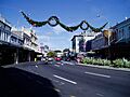
Karangahape Road from the intersection with Pitt Street, showing the H B Building (left), Naval and Family Hotel (right) and Family Bar (centre background)
|
|
| Other name(s) | K' Road |
|---|---|
| Length | 1 km (1 mi) |
| Location | Auckland CBD, Auckland, New Zealand |
| Coordinates | 36°51′28″S 174°45′35″E / 36.8577935°S 174.7597039°E |
| West end | Ponsonby Road, Great North Road, Newton Road |
| East end | Symonds Street, Grafton Bridge |
Karangahape Road (often called K' Road) is a major street in the heart of Auckland, New Zealand. For a long time, it was one of Auckland's best shopping streets. But from the 1960s, new motorways caused many people and shops to move away.
Today, K' Road is known as a cultural hub in Auckland. Since the 1980s and 1990s, it has been getting a makeover. It is now famous for its unique cafes and cool boutique shops. The road runs from west to east along a ridge. It is on the southern edge of Auckland's city centre. It crosses Queen Street, which is the city's main street. To the west, it meets Ponsonby Road and becomes Great North Road. To the east, it connects to Grafton Bridge.
Contents
Understanding the Name: Karangahape Road
The name Karangahape comes from the Māori language. Before Europeans arrived, different Māori tribes lived in Auckland. They all used a similar name for the Karangahape Ridge. The exact meaning of the name is not fully known. Some ideas include "winding ridge of human activity" or "calling on Hape."
Hape was a tohunga (a skilled priest or navigator). He was part of the Tainui canoe journey. He lived near the Manukau Harbour. The ridge was a walking path, known as Te Ara o Karangahape. This means The Path of Karangahape. So, the name might mean the path people took to visit Hape.
Until the mid-1900s, Karangahape Road was the only street in central Auckland with a Māori name. This was because Māori people used it as a main route long ago. Many early European settlers found the name hard to say. They often just called it "The Road."
In 1908, some people wanted to change the name to something more European. There were many public meetings and newspaper talks. But the city council decided to keep the original name. The idea came up again in 1913 and just before a Royal Tour in 1953. They even suggested "Elizabeth Street." But each time, the name Karangahape Road stayed. Since the early 1900s, it has been widely known as "K Road."
A Look Back: History of K' Road


Karangahape Road is older than Queen Street. Māori people used it as a travel route before Europeans arrived. Queen Street was only built by Europeans in the 1840s. In 1841, the land was sold by local Māori to the government. Karangahape ridge was the southern edge of Auckland City in the 1800s. In 1882, nearby areas like Newton joined Auckland City.
From about 1900 to the early 1960s, K' Road was Auckland's busiest shopping street. It had many clothing and shoe shops. There were also several department stores. Most big retail chains had stores here, often preferring K' Road over Queen Street. Between the two World Wars, many shops selling furniture, musical instruments, and home appliances were here.
In 1908, gas streetlights were replaced with electric ones. In 1935, electric lights were added under shop awnings. This created a "Great White Way" that lit up a mile of shops. It made late-night shopping feel very glamorous. In 1948, the second set of traffic lights in Auckland was put at the Pitt Street crossing. These were the first lights to have special times for pedestrians to cross. In 1949, K' Road got New Zealand's first fluorescent street lights.
The Karangahape Road Business Association (KBA) started in 1911. It was a group of business people in the area. It officially began in 1924. Its first president was Mathew James Bennett.
In the mid-1900s, Karangahape Road was a popular shopping spot. It was especially busy at night with families. They often came by public transport. A line was even painted down the middle of the footpaths to help people walk in order. Police were sometimes at the Pitt Street crossing. This was to stop people from being pushed into traffic. A typical night out included watching a movie, shopping, eating, and window shopping. At this time, the street had five cinemas and many dance halls. One dance hall, the Druid's Hall, is still a music venue today.
K' Road had many shops for beauty and fashion. These included fabric, clothing, shoes, and hair salons. Many photographers' studios were also along the ridge. There were fancy dress shops and furriers. Many places specialized in wedding fashions and photos.
Before the 1980s, shops were not open on Saturdays or Sundays. But Karangahape Road was still lively on weekends. Most weddings happen on a Saturday. Groups of women would wait outside photographers' studios. They hoped to see wedding parties arriving or leaving. Sundays were also social. Until the 1960s, people regularly went to church in the area.
The Karangahape Road area had several major places of worship. These included the Baptist Tabernacle and the Pitt St Methodist Church. Many other groups also had halls here. These included the Salvation Army, Pacific Island Church, and the Maori Hall. These places often held services, talks, or social events.
After 1965, K' Road lost many local customers. This happened because new motorways were built in the city centre. Over 50,000 people had to move out of nearby areas. This led to many shops closing. Businesses moved to other parts of Auckland. This made the decline of the area happen faster.
Today, K' Road has a mix of shops, cafes, and art galleries. Since the early 1990s, it has become a popular place for nightlife. Its restaurants, bars, and nightclubs make it a big part of Auckland's social scene.
People and Population in Karangahape
The Karangahape area is about 0.29 square kilometers. In 2018, its population was 2,307 people. This was a big increase from 2006. The median age was 32.6 years. Most people were between 30 and 64 years old.
Many different cultures live in Karangahape. In 2018, about 61.9% of people were European. About 29.6% were Asian. Other groups included Māori and Pacific peoples. More than half of the people were born outside New Zealand. Most people said they had no religion. Others were Christian, Hindu, Muslim, or Buddhist. Many people in the area have a university degree. The median income was $43,800. Most people were employed full-time.
Important Buildings and Landmarks
You can take guided walks to see the historic buildings on Karangahape Road. Here are some notable places:
Near Symonds Street


- Cordis Hotel: This hotel is at the corner of Karangahape Road and Symonds Street. A windmill called Partington's Windmill stood here from 1850 to 1950. Its removal led to laws protecting old buildings.
- Grafton Bridge: Built in 1910, this large concrete bridge is at the eastern end of Karangahape Road. It spans Grafton Gully. When it was finished, it was the largest concrete single-span bridge in the world.
- 1910 Tram Shelter: This fancy tram shelter was built in 1910. It includes public toilets. These might have been the first public toilets for women.
- Symonds Street Cemetery: This is one of Auckland's oldest cemeteries. It was the first official burial ground. Many early settlers are buried here, including Captain William Hobson. He was New Zealand's first Governor. When the motorway was built in the 1960s, over 4100 bodies were moved. They were reburied in two memorial sites within the cemetery.
- Jewish Centennial Memorial Hall: This building from 1953 is in a modern style. It remembers the first Jewish religious ceremony in New Zealand in 1853.
Near Queen Street
- Former Bank of New South Wales: This building from 1926 is in a Neo-Georgian style. This style was very popular for banks.
- Baptist Tabernacle: Built in 1884, this brick building is in an Imperial Roman style. Its front looks like the Pantheon in Rome.
- Ironbank: This modern building from 2009 has won awards. It is known for looking like "rusting containers."
- J Morris Ltd: This English Baroque style building was for a homewares store. J Morris Ltd organized Auckland's first Auckland Christmas Parade in 1912.
- The Bristol: This Neo-classical building was a piano showroom.
- Verona Buildings: This Neo-Greek style building from 1923 is named after an older wooden house that was on this site.
- St Kevin's Arcade: This shopping arcade from 1924 is in a 1920s Neo-Greek style. It has an entrance to Myers Park. This was once the site of the second Government House in Auckland.
- Myers Park: This park is on the slope of the Karangahape ridge. It was created by and named after Arthur Myers. This gully was the start of the Waihorotiu Stream.
- Former Rendell's Department Store: This brick building from 1904 is in an Italianate style.
Near Pitt Street
- Pitt Street Buildings: This block of shops from 1904 is in the Queen Anne Style. Its gables make it a symbol of the area.
- Pitt Street Methodist Church: This Gothic building from 1866 has sculptures by Anton Teutonberg. He was the first European sculptor in New Zealand.
- Central Fire Station: This Queen Anne style building from 1902 was designed by Goldsboro & Wade.
- Former Beresford Street Congregationalist Church: This Neo-Greek style building from 1875 is possibly the second oldest concrete building in New Zealand. It is now called Hopetoun Alpha.
- Naval & Family Hotel: This ornate three-story building from 1897 has Italianate and Queen Anne influences.
- Former Palace Theatre: This building was a cinema in 1911. Later, it became shops and a dance floor.
- Former George Court and Sons Department Store: This building from 1924 was based on Selfridges in London. The Court brothers opened their first shop on K' Road in the 1890s.
- Mercury Theatre: This English Baroque style building from 1910 is Auckland's oldest surviving theatre. It was once the King's Theatre.
- Norman Ng Building: This building from 1926 was the entrance to a cinema. After the cinema closed, Norman Ng ran a fruit and vegetable shop here. It has original Art-Deco features inside.
Near East Street
- Samoa House: This modern building houses the Samoan Consulate. It includes the first Fale (traditional Samoan house) built outside of Samoa.
- Newton Post Office: This modern building from 1973 has a bronze artwork on its front by Guy Ngan.
- Former Le Bon Marche Department Store: This store was once New Zealand's biggest hat shop. It even had an indoor miniature golf course for customers.
- Former Vogue Picture Theatre: This cinema, built in 1914, later became a nightclub. Parts of its 1930s interior still exist.
- Wrights Confectionary Factory: This 1917 building had a factory above a cake shop.
- Former Newton Hotel: This building probably dates from around 1866. It might be the oldest building in the area.
Near Howe Street
- "Chaise Lange": This is a sculptural seat by New Zealand artist Peter Lange.
- Hellaby's Corner: This building was once a butcher shop. It is now the Thirsty Dog Pub.
- Garrets Block: These brick buildings from 1886 were for a boot making and selling business.
- Purchas Block: Designed in 1884, these buildings use expensive English red brick.
Near Edinburgh Street
- Pacific Island Church: This is the first Pacific Island Church in New Zealand. The current building is from 1962. It was used for wedding scenes in the film Sione's Wedding.
- Pacific Island Church Memorial: Outside the church is a granite monument. It was put up in 1997 to celebrate 50 years of the church.
- Maori Hall: This building from 1907 was a Foresters Hall. It became a Māori community centre in 1931.
Near Hereford Street
- M.J.Bennett Building: Built around 1902 for a decorating firm. Mathew James Bennett was the first president of the Karangahape Road Businessmen's Association.
- Old Folks Coronation Hall: This community hall from 1953 was partly funded to celebrate the Queen's Coronation.
Near Ponsonby Road
- Ponsonby Reservoir: This reservoir gets water from the Waitākere Ranges.
- Vaana Peace Mural: This mural was created in 1985 by artists against nuclear weapons. It was remade in 2006 with more panels.
K' Road and Media Connections
Karangahape Road was home to some of New Zealand's earliest radio stations. In 1923, Charles Pearson started the first radio station in Auckland. It was later called 1ZB. His morning announcer, Maud Basham, became famous as Aunt Daisy.
The first broadcasting house in Auckland operated from 1925 to 1931. It had large radio antennae on top of the George Courts building. It ran a commercial radio station called 1YA.
K' Road has recently become a hub for film and video. It has six independent filmmakers and three places to watch films.
Two radio stations, K FM Radio and Boosh.FM, operate from the street. K FM Radio plays different types of music like reggae, jazz, and hip-hop. This music reflects the diverse culture of Karangahape Road.
K' Road in Films and TV
Karangahape Road has been featured in several films and TV shows:
- 1987: Walkshort (short film)
- 1987: Jewel's Darl (short film)
- 1995: A TV interview with Jordan Luck of The Exponents, filmed on a K' Road rooftop.
- 1998: "I Can Change" by Trip to the Moon (music video)
- 1999: "Ode to K' Rd" by "Peter Stuyvesant Hitlist" (music video)
- 2004: 1Nite (full-length film)
- 2005: The song "Verona" by Elemeno P.
- 2006: Sione's Wedding (wedding scene filmed at the Pacific Island Church).
- 2012: Sione's 2: Unfinished Business (outdoor scenes shot on K' Road).
Famous Shops on K' Road
Many well-known shops and brands in New Zealand started on Karangahape Road or had a branch there.
From the 1800s to World War I
- Partington's Victoria Flour Mill: A mill and biscuit factory.
- Lewis Eady: A piano importer, still a big music store today.
- Wendals Wine Bar: New Zealand's first wine bar (1876).
- Rendells: A clothing store, known for being the first specialist babywear shop in NZ.
- M.J. Bennett Ltd: A top paint shop and decorating firm.
- J. Morris Ltd: A homewares store that organized Auckland's first Christmas Parade in 1912.
- George Court & Sons: A major department store.
- Hallenstein Brothers: Still a national menswear retailer.
- Hannahs: A major shoe retailer.
- Buchanans: A famous confectioner, now Buchanan's Bread.
- Wrights Confectionery Factory: A factory and cake shop.
- The Bon Marche: New Zealand's biggest hat shop.
- Pascoes: The main store of a jewelry chain.
- The King's Theatre: Opened in 1910, now the Mercury Theatre.
Between the World Wars
- Stevens: A china and gift shop, now a large chain.
- Levenes: A paint and wallpaper store, became a national chain.
- Winters Hairdressing: A famous salon.
- Flacksons: Ladies outfitters and beauty salon.
- Colefax Menswear: A menswear store that kept its 1950s style for a long time.
- Woolworths: Part of a nationwide chain.
- Whitcombe and Tombes: A chain of bookshops, now Whitcoulls.
- Leo O'Malley's: A menswear store, one of the oldest on K' Road.
- Adams Bruce: A famous bakery.
- Dominion Wine Bar: Once the only wine bar in the Auckland Province.
- The Vogue Picture Theatre: Opened in 1940, now a nightclub.
After World War II
- Peter Pan Ballroom & Cabaret: One of Auckland's main nightclubs.
- Garth Chester: A furniture showroom for a famous modernist designer.
- Para Rubber: A company that occupied the former Vogue Cinema.
- LaGonda: A ladies fashion store.
- Hi Diddle Griddle: One of Auckland's most famous restaurants in the 1950s.
- The Auckland Doll Hospital: A toy shop and repair service.
- The Mercury Theatre: An important live theatre.
- Norman Ng's Fruit Shop: Known as the only fruit shop with a marble floor.
- Verona: A Bohemian Café, still popular today.
From the 1980s Onwards
- St Kevin's Arcade 2nd Hand Bookshop.
- Brazil: A coffee house.
- Alleluya: A café in St Kevin's Arcade.
- Dick Smith: One of the chain's earliest stores in New Zealand.
- Iko Iko: A giftware retailer.
- Bergman Gallery: An art gallery.
- Tautai Pacific Arts Trust: An art gallery.
- The Thirsty Dog: A bar.
- The Grow Room: A place for art, music, and poetry.
Notable People Who Lived Near K' Road
Many interesting people have lived in the Karangahape Road area:
- David Nathan (1816–1883): A merchant and Jewish community leader.
- Sir George Grey (1812–1898): A Premier of New Zealand and Governor.
- Rev John Kinder (1819–1903): A clergyman, headmaster, and early photographer.
- Major General Sir Duncan Cameron (1808–1888): Commander of British forces in New Zealand.
- Major General Sir George Dean Pitt (1772–1851): Lieutenant-Governor of New Ulster Province.
- Charles Partington: A windmill owner.
- Lewis Eady: A piano importer.
- Samuel Vaile: Founder of a real estate company.
- Baron Charles de Thierry (1793–1864): An adventurer and music teacher.
- Philip Herapath: An architect.
- Rev Dr Arthur Guyon Purchas (1821–1906): A clergyman, surgeon, and musician.
- Israel Wendel: The first owner of a wine bar in New Zealand.
- David Goldie (1842–1926): A Mayor of Auckland.
- Joseph Partington (1851–1941): A windmill owner.
- William Henry Thomas Partington (1855–1940): A photographer.
- Charles Goldie (1870–1947): A famous New Zealand portrait painter.
- Arthur Mielziner Myers (1868–1926): A Mayor of Auckland and Member of Parliament.
- David Lawrence Nathan (1882–1944): The last owner of St Kevins House.
- Eve Maria Langley (1904–1974): A poet and novelist.
- Colin McCahon (1919–1987): A renowned New Zealand painter.
- Bob Harvey (1940 – ): A former Mayor of Waitakere City.
- John Banks (1946 – ): A former Mayor of Auckland City.
- Ahmed Zaoui: A refugee who resided in the Dominican Priory.
Images for kids
-
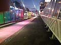
colourful rainbow fencing and bus shelters on Grafton Bridge lit at night
-
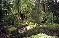
Symonds St Cemetery.
-
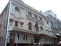
stone front brick side of Mercury Theatre
-
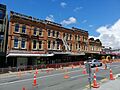
444-472 Karangahape Road, east of the Edinburgh Street intersection.
-
Western part of K'Road, looking east.


