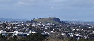
Mount Wellington, New Zealand facts for kids
Quick facts for kids
Mount Wellington
|
|
|---|---|
|
Suburb
|
|
 |
|
| Country | New Zealand |
| Local authority | Auckland |
| Electoral ward | Maungakiekie-Tāmaki ward |
| Local board | Maungakiekie-Tāmaki Local Board |
| Area | |
| • Land | 1,036 ha (2,560 acre) |
| Population
(June 2023)
|
|
| • Total | 28,030 |
| Train station(s) | Sylvia Park Railway Station |
|
|
||
Mount Wellington is a lively suburb in East Auckland, New Zealand. It's about 10 kilometers (6 miles) southeast of Auckland's main city center. This area is surrounded by other suburbs like Stonefields, Tamaki, Panmure, Penrose, and Ellerslie. The Tāmaki River also flows nearby.
The suburb gets its name from a famous volcanic hill called Maungarei / Mount Wellington. A very popular place here is Sylvia Park, which is a huge shopping center and business area.
Contents
Exploring Mount Wellington's Geography
Mount Wellington is known for its unique natural features.
The Maungarei Volcano
The suburb is named after Maungarei / Mount Wellington, a volcanic peak that is 135 meters (443 feet) tall. This volcano is part of the Auckland volcanic field. It's the newest volcano on land in Auckland, having formed about 10,000 years ago. It's also the largest of Auckland's scoria cones, which are cone-shaped hills made from volcanic rock fragments.
Before European settlers arrived, the land around Maungarei was mostly covered in bracken scrub. It wasn't heavily forested. The southern part, closer to Ōtāhuhu / Mount Richmond, had more broadleaf and podocarp forests. There were also some open scrubland areas.
A Look at Mount Wellington's History
Mount Wellington has a rich history, especially with the Māori and its role in providing food.
Early Māori Settlement
The land south of the mountain was traditionally home to Ngāi Tāhuhu. These people were descendants of Tāhuhunui-o-te-rangi, who was the captain of the Moekākara waka (canoe). He is also the person Ōtāhuhu is named after.
Archaeologists have found four old sites near Carbine Road and Panama Road, close to the Tāmaki River. These sites were used in the mid to late 1500s. Many storage pits for root vegetables, like kūmara (sweet potato), were discovered. This shows that Māori extensively farmed the area. They also made toki (adzes) here, which were tools used for carving and woodworking.
Important Portage Route
South of Mutukaroa / Hamlins Hill was a place called Karetu. This was a 2-kilometer (1.2-mile) portage. A portage is a path where canoes could be carried overland between two waterways. Karetu connected the Waitematā Harbour/Tāmaki River with the Manukau Harbour. This made it easier to travel across the land by water.
Farming and Industry
For a long time, Mount Wellington was a major source of vegetables for Auckland. This was true alongside the Tāmaki area. However, in the 1940s, much of this farmland was changed into an industrial area.
Mount Wellington's Population and People
Mount Wellington covers about 10.36 square kilometers (4 square miles). It has a large and diverse population.
Population Overview
As of 2023, Mount Wellington has an estimated population of around 30,000 people. The population density is about 2,900 people per square kilometer. This means many people live in a relatively small area.
Most of the suburb is residential, meaning people live in homes there. However, Sylvia Park is almost entirely commercial, with shops and businesses. The central area of Mount Wellington Industrial is mainly for factories and industries.
Who Lives in Mount Wellington?
In the 2018 New Zealand census, Mount Wellington had 25,236 people. This was an increase from previous years. There were slightly more females than males. About 18.7% of the population was under 15 years old.
People in Mount Wellington come from many different backgrounds. The main ethnic groups include European/Pākehā, Māori, Pacific peoples, and Asian. Many people living here were born overseas, which adds to the suburb's diverse culture.
When it comes to beliefs, about 33.1% of people said they had no religion. Many people identified as Christian (43.6%). Other religions like Hindu, Muslim, and Buddhist are also present.
Many adults in Mount Wellington have a bachelor's degree or higher. Most people aged 15 and over are employed full-time.
Economy and Shopping in Mount Wellington
Mount Wellington is a hub for shopping and business in Auckland.
Sylvia Park Shopping Centre
Sylvia Park shopping centre is a very popular destination. It first opened in 2006 and has been upgraded since then. It has a huge area of 106,427 square meters (1,145,570 square feet) for shops. There are also over 4,000 parking spaces.
Sylvia Park has about 250 stores. Some of the main stores include The Warehouse, Farmers, Kmart, and Pak'nSave. It also has a large Hoyts Cinema with 10 screens.
Mt Wellington Shopping Centre
Another shopping area is the Mt Wellington Shopping Centre. It has 22 stores across 9,000 square meters (96,875 square feet). Key stores here are Countdown and Supercheap Auto.
Learning in Mount Wellington: Schools
Mount Wellington has several schools for young people.
Primary Schools
- Bailey Road School: This is a full primary school, teaching students from Year 1 to Year 8.
- Stanhope Road School: Also a full primary school for Years 1 to 8.
- Sylvia Park School: Another full primary school, covering Years 1 to 8.
- Panama Road School: This is a contributing primary school, teaching students from Year 1 to Year 6.
All these schools are coeducational, meaning both boys and girls attend them.
 | Ernest Everett Just |
 | Mary Jackson |
 | Emmett Chappelle |
 | Marie Maynard Daly |


