St Johns, New Zealand facts for kids
Quick facts for kids
St Johns
|
|
|---|---|
|
Suburb
|
|

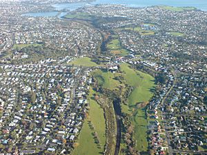
St Johns, in the foreground and left.
|
|
| Country | New Zealand |
| Local authority | Auckland |
| Electoral ward |
|
| Local board | Ōrākei Local Board |
| Area | |
| • Land | 165 ha (408 acre) |
| Population
(June 2023)
|
|
| • Total | 6,150 |
|
|
||
St Johns is a lively suburb located in Auckland, New Zealand. It's known for its history and green spaces. The suburb gets its name from a very old college that was built here long ago.
The Story Behind the Name
St Johns is named after St John's College. This college was a special school for religious training. It was started in 1844 by Bishop Selwyn. The college is still used today by the Anglican Church in New Zealand.
College Buildings and Style
The college buildings sit on top of a hill. From here, people used to have amazing views of the harbour. The first buildings were designed in the 1840s by Frederick Thatcher. He was Bishop Selwyn's main architect.
Thatcher created a unique look called the "Selwyn Style." These buildings are made of wood and have a Gothic design. They look a bit like old Saxon churches, especially Greensted Church in England. You can spot them by their strong wooden beams on the outside. They also have steep, pointed roofs and tall, narrow windows.
Waiatarua Reserve: From Swamp to Park
South of Remuera Road, you'll find Waiatarua Reserve. This area is a natural dip in the land. It used to flood a lot during rainy seasons. Old maps from the 1800s sometimes showed it as a lake. People called it 'Lake Remuera' or 'Lake St John'. But it was mostly a swampy area with shallow water appearing only sometimes.
Creating a Community Space
In 1918, about 133 hectares of this land were given to the City Council. The idea was to create Waiatarua Reserve. As more houses were built nearby, the swamp became a problem. It was a breeding ground for mosquitoes and sometimes smelled bad. This was because the ground was made of a peat-like material that could smoulder (burn slowly).
In 1929, a drain was dug through a nearby hill. This allowed the water to flow into a stream that leads to the Ōrākei Basin. This drainage system still works today.
The Remuera Golf Club
In 1934, 50 hectares of the park were leased to the Remuera Golf Club. A golf course was built, and the clubhouse opened in 1935. Over the years, the course was improved. In 1968, a golf expert named Harold Babbage redesigned it. A new clubhouse was also built then.
St Johns Today
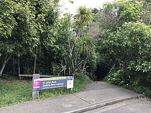
Most of St Johns was developed in the 1960s and 1970s. Back then, it was a very popular place for families to live. The area is part of the zone for Selwyn College. This is the local public high school. Close by, you can also find St John's Bush. It's a small piece of native forest that remains in the area.
Population and People
St Johns covers about 1.65 square kilometers. It is home to over 6,000 people. The population has grown steadily over the years. For example, between 2006 and 2018, the number of people living here increased by about 8.7%.
Who Lives in St Johns?
In 2018, there were nearly 6,000 people living in St Johns. This included slightly more females than males. About 17.6% of the people were under 15 years old.
The people of St Johns come from many different backgrounds. Many are of European descent. There are also significant numbers of Māori, Pacific peoples, and Asian residents. About half of the people living in St Johns were born outside of New Zealand.
 | Stephanie Wilson |
 | Charles Bolden |
 | Ronald McNair |
 | Frederick D. Gregory |


