Lynfield, New Zealand facts for kids
Quick facts for kids
Lynfield
|
|
|---|---|
|
Suburb
|
|

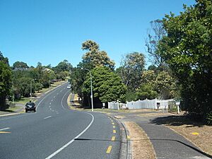
Halsey Drive in Lynfield
|
|
| Country | New Zealand |
| Local authority | Auckland |
| Electoral ward | Albert-Eden-Puketāpapa ward |
| Local board | Puketāpapa Local Board |
| Area | |
| • Land | 252 ha (623 acre) |
| Population
(June 2023)
|
|
| • Total | 8,560 |
|
|
||
Lynfield is a suburb in Auckland, New Zealand. It is managed by the Auckland Council. This area is on the southwestern part of the Auckland isthmus, right next to the Manukau Harbour. Many parts of Lynfield are covered in thick native forests. The suburb was built for homes in the late 1950s and 1960s. Its design was inspired by American-style neighbourhoods.
Contents
What's in a Name? The Story of Lynfield
The name Lynfield first appeared in the early 1900s. An Australian farmer named Albert William Irvine started a chicken farm. He moved his farm to land owned by Sir Alfred Bankart in 1913. Irvine named his farm "Linfield" after Lindfield, New South Wales, where his wife was born.
Before Lynfield College opened in 1958, parents and teachers picked the name Lynfield. They chose it because of the Linfield poultry farm, which was next to the school. The college's name then became the name for the whole modern suburb. This suburb grew south of the school.
Lynfield's Location and Landscape
Lynfield is like a small arm of land reaching into the Manukau Harbour. It has Lynfield Cove on its west side and Wattle Bay on its east side.
The Wairaki Stream, also called Duck Creek, flows through Lynfield. It empties into the Manukau Harbour at Lynfield Cove.
A Look Back: Lynfield's History
People have lived in this area since at least the 1200s. These were Tāmaki Māori iwi and hapū groups. By the early 1700s, the area was part of the land of Waiohua. Later, after a battle, it became part of the land of Ngāti Whātua (today known as Ngāti Whātua Ōrākei).
In 1910, Sir Alfred Bankart bought land between White Swan Road and the Wairaki Stream. He called it the Gilletta Estate. He then divided this land into smaller plots between 1919 and 1922. In 1913, Albert William Irvine moved his Linfield Poultry Farm here. He needed more space for his growing business. By the next year, Irvine moved the farm north, but the name "Linfield" stayed connected to the area.
In 1911, the government gave the land to the Auckland Harbour Board. This board then developed the area into a suburb with houses in the late 1950s and 1960s. They hired a town planner named Robert Terence Kennedy. He designed Lynfield to look like American suburbs. The suburb has one main road, Halsey Drive, which winds through the area. Another road, The Avenue, was designed like a grand Parisian street. The developers named the streets after fancy cruise liners that visited Auckland.
At first, the Auckland Harbour Board rented out the houses. People could rent them for 21 years. But residents wanted to buy their homes. In 1968, they gave a petition with 150 names to the Harbour Board. In 1974, the board finally agreed to let people buy their properties. This happened because the Harbour Board needed more money.
Lynfield's first shop was a Four Square supermarket, which opened in 1965. More houses continued to be built in the area until the late 1970s.
In 1975, a tiny beetle species called Microscydmus lynfieldi was found in the Wairaki Stream in Lynfield. It is one of the smallest beetles in the world!
Who Lives in Lynfield?
Lynfield covers about 2.52 square kilometres. As of June 2023, about 8560 people live here.
In 2018, Lynfield had a population of 7,503 people. This was an increase of 741 people since 2013. There were 2,247 households. About 17% of the people were under 15 years old.
People in Lynfield come from many different backgrounds. In 2018, the main ethnic groups were:
Many people in Lynfield were born overseas (57.6%). This is much higher than the national average of 27.1%.
When it comes to beliefs, about 29.4% of people said they had no religion. Others followed different religions like Christianity (31.3%), Hinduism (22.0%), and Islam (7.6%).
Cool Places and Things to Do in Lynfield
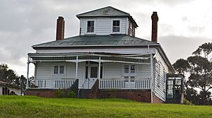
- 143 White Swan Road: This old farmhouse was built around 1913. It's one of the few houses left from before the 1950s. Today, it's an early learning centre for kids.
- Lynfield Community Church: This church started in 1967.
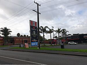
- Lynfield Shopping Centre: This is a shopping area on the corner of Hillsborough Road and The Avenue.
- Lynfield Tennis Club: This club opened in 1972 at Oriana Reserve.
- Maungakiekie Golf Club: This large golf course moved to Lynfield in 1946.
- Manukau Harbour Coastline: The coast between Lynfield Cove and Wattle Bay has many nature reserves and parks. These include Lynfield Cove Reserve and Manukau Domain. The Waikōwhai Walkway is a public path along the coast. It connects Lynfield Cove to Onehunga.
- Opened Stone: This is a sculpture by a Japanese artist named Hiroaki Ueda. It was put in Manukau Domain in 1972.
- Wairaki Stream: This two-kilometre stream is surrounded by native forest. A group of volunteers called the Friends of Wairaki Stream (FOWS) helps protect it.
Schools in Lynfield
Lynfield has several schools for students of different ages:
- Lynfield College: This is a secondary school for students in years 9 to 13. It opened in 1958.
- Halsey Drive School: This is a primary school for years 1 to 6. It opened in 1968.
- Marshall Laing School: This is also a primary school for years 1 to 6. It opened in 1962. It is named after the son of George Laing.
All these schools welcome both boys and girls.
Famous People from Lynfield
- The family of singer Daniel Bedingfield is from Lynfield.
- Motor racing driver Mitch Evans lives in Lynfield with his family when he is not racing overseas.
- Housing developer and evangelist Bill Subritzky and his family lived in Lynfield from the 1960s until he passed away in 2015.
 | John T. Biggers |
 | Thomas Blackshear |
 | Mark Bradford |
 | Beverly Buchanan |


