
Westmere, New Zealand facts for kids
Quick facts for kids
Westmere
|
|
|---|---|
|
Suburb
|
|
1916.png)
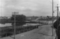
Southwestwards view across Coxs Bay of Westmere, 1916
|
|

Westmere
Location in New Zealand
|
|
| Country | New Zealand |
| Local authority | Auckland |
| Electoral ward | Waitematā and Gulf ward |
| Local board | Waitematā Local Board |
| Area | |
| • Land | 65 ha (161 acre) |
| Population
(June 2023)
|
|
| • Total | 2,190 |
| Postcode(s) |
1022
|
|
|
||
Westmere is a cool place to live in Auckland, New Zealand. It's a suburb located right on the southern shore of the Waitematā Harbour. This area used to be a peninsula, which is land surrounded by water on three sides. Westmere is about 6 kilometres (3.7 miles) west of Auckland's city centre. The local government, called the Auckland Council, helps manage the area.
Contents
Westmere's Story: A Look Back in Time
Before Europeans came to Auckland, Westmere was a busy spot for Māori people. They often travelled through this area. It was also a great place to find food and fresh water. People have found old shell piles, called middens, along the coast. These show that Māori enjoyed lots of seafood from the area. They also gathered flax from the wetlands in Coxs Bay to make ropes and clothes.
Early European Settlers Arrive
Westmere was not part of the land given to the government in 1840. Instead, Coxs Creek was used as a boundary line. Land in Westmere started to be sold off in 1844.
Westmere was once part of a larger area called Richmond. This included Coxs Bay and part of Grey Lynn. Maps from the 1860s show this. The main road through Westmere was first called Wolseley Road. It was renamed Garnet Road in 1917. In 1886, a new bridge was built over Coxs Creek. This made it easier to get around.
A special building called Lynton Lodge was built in 1890. It has been a place for long-term care for most of its history.
Industries in the Past
Besides farms, Westmere had several businesses that worked with meat. From 1877 to 1908, there were abattoirs (places where animals are processed for meat). The city abattoir opened in 1877. It was later developed into Notley Street in 1940. This facility closed in 1908 when a new one opened elsewhere.
In 1884, a tannery called Bridgenorth Tannery was built. Tanneries process animal hides into leather. Other slaughterhouses and businesses also operated in the area.
From 1897, the city used a spot near Meola Creek to dump refuse. This area later became part of Meola Road. By 1903, people thought it was a health problem.
New Homes and Changes
In 1923, a new housing area called the Westmere Estate was launched. This is when the name "Westmere" started to become popular. The word "mere" means lake in British English. A causeway, which is like a raised road over water, was built. This created a lake-like area at Coxs Creek.
Many of the first homes built were for workers. They often had a Californian bungalow style. This was a popular type of house back then.
From the mid-1920s, a landfill was used to build a causeway. This connected Meola Road to Garnet Road. In 1926, the West End Road causeway was made wider. It also got footpaths, and the old wooden bridge was replaced with a new concrete one.
In 1927, St Cuthbert's Anglican Church Hall opened. It was a busy place for community activities and Sunday school. The building closed in 2007 and is now a home.
During the Great Depression in the 1930s, some properties in Westmere were hard to sell. The West End Lawn Tennis Club started in 1932. Later, some state houses were built. People even thought about building an airport by filling in part of the harbour!
The West End Road landfill was used from 1950 to the 1970s. In 1960, a new bridge and road at Coxs Creek made driving easier. The Meola Road landfill continued until 1970. The road connection to Point Chevalier was finished in 1950. This linked Westmere to the western suburbs and the city.
Westmere Today
By 2000, house prices in Westmere had gone up. It became a mostly middle-class suburb. Homes along the shoreline often have great harbour views. Many houses have been made taller, now having two floors.
You can find restaurants, cafes, takeaways, and shops in Westmere. To the east, there's Cox's Bay Reserve. This park has a boardwalk through mangrove swamps, sports fields, and playgrounds. To the west, you'll find the MOTAT Aviation Hall and Meola Bay Reserve, which covers the Meola Reef.

In 2016, Westmere had the most expensive state house in New Zealand. It was worth $2.54 million! That same year, the Weona–Westmere Coastal Walkway opened. This is a nice path along the coast.
Westmere is a compact neighbourhood with about 1,700 homes. In 2023, the average house price was around $2.4 million.
How Westmere is Governed
In the 1860s, Westmere was part of Newton Borough. Later, it became part of the Grey Lynn Borough. In 1887, Grey Lynn was divided into wards. Wolseley Road (now Garnet Road) was in the Richmond Ward.
In 1914, Grey Lynn Borough joined the Auckland City Council. Then, in 2010, Auckland City Council merged with other councils to form the Auckland Council. Westmere is now part of the Waitematā and Gulf Ward. This means local decisions are made by the Waitematā Local Board.
Schools in Westmere
Westmere has its own primary school. The land for the school was bought in 1882. To help with crowded schools nearby, Richmond West School opened in July 1914. It had three classrooms, an office, and a staff room.
In 1930, the school's name changed to Westmere School. This was to avoid confusion with another school. Over the years, new buildings were added. The old school hall was replaced in 2012. In 2015, the school got seven new classrooms and 11 replacement ones.
Westmere School | Te Rehu is a school for students in Years 1–6. It has a roll of 353 students as of February 2024. .
After primary school, students often go to Pasadena Intermediate School in Point Chevalier. This school is easy to reach by walking or cycling. Before Pasadena Intermediate opened in 1942, Westmere School also taught Years 7–8.
For high school, the closest state school is Western Springs College. Other options include Avondale College and Mount Albert Grammar School.
Getting Around: Public Transport and Cycleways
Westmere used to have trams! They ran from 1923 to 1953 to the Auckland Zoo. Trams also ran to Westmere itself from 1931 to 1953.

Before the tram tracks reached the zoo in 1923, the closest stop was in Grey Lynn. In 1931, the Westmere tram service began. In 1935, a tram going to the zoo accidentally went onto Garnet Road and crashed into another tram!
After trams, trolley buses took over. Later, diesel buses were used. Today, buses connect Westmere to other parts of Auckland.
In 2016, Auckland Transport suggested changes for Westmere. These included new cycleways, bus stops, and pedestrian crossings. Construction on the Westmere cycleway started in late 2023.
Famous People from Westmere
Many interesting people have lived in Westmere:
- Lisa Greenwood (born 1955), a writer.
- Charles Gregory (1901–1988), a rugby league player.
- Julie Le Clerc, a chef and TV host.
- Bryan Little (born 1966), a football player.
- Mike McRoberts (born 1966), a TV journalist.
- Nathaniel Neale (born 1988), a rugby league player.
- Pavlina Nola (born 1974), a tennis player.
- Vincent O'Sullivan (born 1937), a writer.
- Allan Pearce (born 1983), a football player.
- Graham Pearce (born 1977), a football player.
- Roy Powell (1907–1980), a rugby league player.
- Riki van Steeden (born 1976), a football player.
- Bryan Williams (born 1950), a rugby union player.
Westmere's Population: Who Lives Here?
The area called Westmere North is a bit smaller than the whole suburb. Westmere North covers about 0.65 square kilometres (0.25 square miles). In 2023, it had an estimated population of 2,190 people. This means there are about 3369 people per square kilometre.
In the 2023 New Zealand census, Westmere North had 2,304 people. This was a small decrease from 2018. The average age was 41.5 years. About 19.1% of people were under 15 years old.
People in Westmere come from many different backgrounds:
- 85.9% were European (Pākehā).
- 9.9% were Māori.
- 5.5% were Pasifika.
- 9.9% were Asian.
- 1.7% were Middle Eastern, Latin American, and African New Zealanders (MELAA).
- 1.2% were other ethnicities.
Most people (97.8%) speak English. Some also speak Māori (2.3%) or other languages.
When it comes to religion, 26.0% of people are Christian. Many people (63.3%) said they had no religion.
Many adults in Westmere have a good education. About 51.2% of people aged 15 or older have a bachelor's degree or higher. The average income was $63,800. Most adults (55.6%) work full-time.
Images for kids
-
Westwards view along West End Rd across Coxs Creek to Westmere, 1926, showing the lake-like body of water created.
_1926.png)
