Wesley, New Zealand facts for kids
Quick facts for kids
Wesley
|
|
|---|---|
|
Suburb
|
|

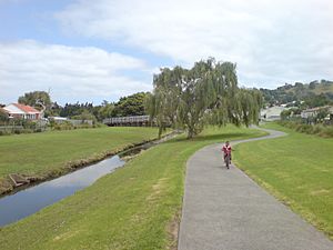
Underwood Park / Walmsley Park in the west of Wesley
|
|
| Country | New Zealand |
| Local authority | Auckland |
| Electoral ward | Albert-Eden-Puketāpapa ward |
| Local board | Puketāpapa Local Board |
| Area | |
| • Land | 197 ha (487 acre) |
| Population
(June 2023)
|
|
| • Total | 5,420 |
|
|
||
Wesley is a suburb in Auckland, New Zealand. It's located in the southwest part of the city's main land area, called the Auckland isthmus. Long ago, in the 1800s and early 1900s, much of Wesley was swampy land owned by the Wesleyan Mission. Later, in the 1940s and 1950s, the New Zealand Government built many homes here as part of a state housing project.
Contents
Where is Wesley?
Wesley is a suburb of Auckland on the Auckland isthmus. It shares borders with other suburbs. To the west is New Windsor, to the south is Mount Roskill, and to the north is Sandringham.
Oakley Creek and Motorway
The suburb is split by the Oakley Creek. This creek flows northwest towards the Waitematā Harbour in Waterview. The Southwestern Motorway also runs through Wesley.
Wesley's Past: A Look Back

People have lived in the Wesley area for a very long time. Tāmaki Māori tribes have been here since at least the 1200s.
Te Auaunga: Oakley Creek's History
The Oakley Creek was traditionally known as Te Auaunga. It was an important place for Tāmaki Māori. They found crayfish, eels, and weka (a type of bird) here. They also gathered plants like harakeke (New Zealand flax) and raupō from the creek banks. These plants were used to make Māori traditional textiles.
By the early 1700s, the area was part of the land of the Waiohua tribe. After their chief, Kiwi Tāmaki, was defeated, the land became part of the Ngāti Whātua tribe's territory. Today, this tribe is known as Ngāti Whātua Ōrākei.
From Mission Land to State Homes
In 1850, the Wesleyan Mission received 280 acres of land from the Crown. This land was between Stoddard Road and Ōwairaka / Mount Albert. It became known as the Mission Swamp or Wesley Estate.
In 1944, the New Zealand Government bought a large part of this land. They called it the Lower Wesley Block. The government then built many state houses here in the mid to late 1940s. This was after they had developed the Upper Wesley Block (now part of Mount Roskill), where Wesley College and the mission were located.
Building the state housing area finished in the early 1950s. Wesley Primary School opened in 1951, and Wesley Intermediate School followed in 1953. A community center was planned for the new suburb. However, the government at the time was less interested in building community centers, so it was never built.
The Black Hall, a private building, was used as a community center for a while. It was built during the 1951 New Zealand waterfront dispute. Sadly, the hall was damaged in 1968.
Flooding Challenges
In 1948 and 1953, Wesley experienced serious flooding from the Oakley Creek. Because of this, the Mount Roskill Borough Council spent a lot of money on projects to prevent future floods around the creek.
People of Wesley
Wesley covers about 1.97 square kilometers. As of June 2023, it has an estimated population of 5420 people. This means there are about 2751 people living in each square kilometer.
Population Changes Over Time
| Historical population | ||
|---|---|---|
| Year | Pop. | ±% p.a. |
| 2006 | 5,163 | — |
| 2013 | 5,370 | +0.56% |
| 2018 | 5,652 | +1.03% |
In 2018, Wesley had a population of 5,652 people. This was an increase of 282 people since 2013, and 489 people since 2006. There were 1,491 households in the suburb.
Diverse Community
Wesley is a very diverse place. In 2018, the people living here included:
Many people in Wesley were born overseas (50.5%), which is higher than the national average for New Zealand (27.1%).
Beliefs and Work
When asked about religion, 23.5% of people said they had no religion. Many were Christian (43.9%). Other religions included Hindu (8.1%), Muslim (15.0%), and Buddhist (1.9%).
About 42.4% of people aged 15 or older had full-time jobs, and 14.0% worked part-time.
Places to See and Things to Do
Wesley has several interesting landmarks and community spots:
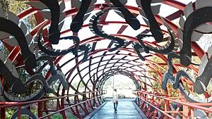
- The Hinaki Eel Trap Bridge: This unique bridge crosses the Oakley Creek.
- Mt Roskill War Memorial Hall: Located in War Memorial Park, this hall remembers those who served.
- The Oakley Creek: This important stream runs through Auckland. It's surrounded by public parks like War Memorial Park, Walmsley Park, and Underwood Park.
- The Wesley Community Centre: Opened in 2003, this building is a great place for community events. It even won awards for its design!
Schools in Wesley
Wesley has two main schools for younger students:
- Wesley Intermediate: This school is for students in years 7–8. It opened in 1953 and has a roll of 57 students.
- Wesley Primary School: This school is for students in years 1–6. It opened in 1951 and has a roll of 153 students.
Both schools welcome both boys and girls. The student numbers are as of February 2024. .
For high school, students in Wesley can attend nearby schools like Mount Albert Grammar School, Marist College, and St Peter's College.
 | Misty Copeland |
 | Raven Wilkinson |
 | Debra Austin |
 | Aesha Ash |


