Sandringham, New Zealand facts for kids
Quick facts for kids
Sandringham
|
|
|---|---|
|
Suburb
|
|

Part of the Sandringham village area
|
|
| Country | New Zealand |
| Local authority | Auckland |
| Electoral ward | Albert-Eden-Puketāpapa ward |
| Local board | Albert-Eden Local Board |
| Area | |
| • Land | 252 ha (623 acre) |
| Population
(June 2023)
|
|
| • Total | 12,220 |
|
|
||
Sandringham (Māori: Hanaringihama) is a lively suburb in Auckland, New Zealand. It's known for being a place where many different cultures live together. More than 12,000 people call Sandringham home.
The heart of the area is Sandringham Village. It's a short walk from the main bus route. This village has a strong South Asian feel. You'll find many restaurants, small supermarkets, and shops selling Halal meat. You can even find places to watch Bollywood movies here.
Nearby suburbs include Mt Eden, Kingsland, and Balmoral. Balmoral also has a strong Chinese influence. In Sandringham Village, you can find a post office, a pharmacy, and places for doctors and lawyers. There's also a real estate office and a community center.
The buildings in the village often have an art deco style. Most of these old buildings are still standing today. The streets around the village have wooden houses called villas and bungalows. These homes were built in the 1920s and 1930s.
To the west, you can see the volcanic hill of Owairaka, also known as (Mt Albert). The Roy Clements Treeway is a path along Meola Creek. It starts near Ferguson Avenue and leads to Rocket Park. This park is a great spot for families and leads to the Mt Albert Community Centre.
Sandringham got its name from Sandringham House. This is a country home in England that belonged to Edward, Prince of Wales. The royal family still uses this house today.
The main road through the suburb is Sandringham Road. It runs mostly north to south. At the northern end, you'll find Kingsland. This area is close to the famous Eden Park stadium. Sandringham Village is at the southern end of Sandringham Road. It's just before the road connects with Mount Albert Road.
Central United is a top New Zealand football club. They play at the Kiwitea Street Stadium in Sandringham. There's also a group called SPiCE (Sandringham Project in Community Empowerment). Local residents started it in 2013. They run fun activities, events, and projects in the area.
Local high schools for students are Mount Albert Grammar School, Marist College, and St Peter's College.
Contents
History of Sandringham
Long ago, the Sandringham area was mostly swampland. The Tāmaki Māori people called it Ngā Anawai. This name refers to the water-filled caves formed by lava flows. These lava caves were created by volcanoes like Maungawhau / Mount Eden and Mount Albert. This happened over 30,000 years ago.
Early European settlers knew the northern part of the area as Cabbage Tree Swamp. This was because of the many tī kōuka (cabbage trees) growing there. These trees lined the swampy land.
In 1841, the Crown bought the Sandringham area from Ngāti Whātua. It was part of a large 12,000-acre piece of land. Sandringham started as a small farming settlement. It was first called Cabbage Tree Swamp because of the cabbage trees and frequent floods. The first European settlers were mostly dairy farmers or grew vegetables to sell.
By 1862, there were sixteen properties along what was then Cabbage Tree Swamp Road. In 1877, people living there asked for the road's name to be changed. It became Kingsland Road. The road and suburb were renamed again in 1916 to Edendale.
In the early 1900s, the suburb of Edendale began to grow. However, it grew slower than other nearby areas. This was because of big problems with flooding. Places like Eden Park and Gribblehirst Park would turn into lakes when it rained heavily. Even the land near the Sandringham shops would flood.
In 1917, a group called the Edendale Ratepayers Progressive Association was formed. They asked the government for help with the flooding. After a big storm in 1919, people remembered using boats to get around the streets. Floodwaters even flowed into houses. Also, by 1900, there was no water supply in the area. By 1924, many homes still didn't have gas or electricity.
The suburb really started to grow in the 1920s. In November 1929, the area changed its name to Sandringham. A lot of new buildings went up around 1925 when the tramline was built. This led to the main part of Sandringham Village being built. Streets of wooden California-style bungalows spread out from Sandringham Road.
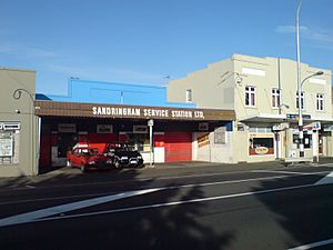
Over the next few decades, more shops were built in Sandringham Village. Around 1927, the Mayfair Cinema was built. It was a beautiful building, but it was taken down in the early 1990s. The Sandringham Service Station, a gas station, was first built in 1929 and is still there today.
From 1909 until 2000, Sandringham was a "no-licence" area. This meant that alcohol could not be sold there. So, there were no pubs in Sandringham for a long time. The first pub, Prague Bar, opened in 2011 (it's now closed). Then, the Lord Kitchener Pub opened in 2016.
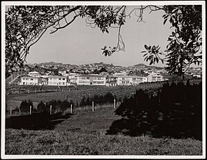
After the Second World War, the remaining farmland was used for state housing. Sandringham Village is a good example of a shopping area from between the two World Wars. The shopping village did well in the 1950s and 1960s. However, it was smaller than shopping streets in nearby suburbs like Mount Albert and Kingsland.
In the 1980s and 1990s, Sandringham became a popular place for different ethnic groups in Auckland. This happened because living in the inner city became too expensive. After the 1987 Fijian coups d'état, many Indo-Fijian people moved to Sandringham. The first Indian restaurant, Stan's Halal Hotpot, opened in 2001. Satya's followed in 2006. More and more South Asian restaurants have opened in Sandringham Village. Because of this, it's often called Auckland's "Little India."
Sandringham's Population
Sandringham covers about 2.52 square kilometers. As of 2023, it has an estimated population of over 12,000 people. This means there are about 4,800 people living in each square kilometer.
In 2018, Sandringham had 12,060 people living there. This was an increase of 822 people since 2013. There were 3,981 households. The population included slightly more males than females. About 18.6% of the people were under 15 years old.
The people living in Sandringham come from many different backgrounds. About 53.2% were European/Pākehā. About 7.0% were Māori. About 10.2% were Pacific peoples. A large group, 36.6%, were Asian. About 3.4% were from other ethnic groups. Many people (44.7%) were born outside New Zealand.
When it comes to religion, about 45.2% of people said they had no religion. About 28.1% were Christian. There were also people who followed Hinduism (14.0%), Islam (3.5%), and Buddhism (1.7%).
Many adults in Sandringham have a good education. About 42.0% of people aged 15 or older had a university degree. Most people were employed. About 56.6% worked full-time, and 14.8% worked part-time.
Education in Sandringham
Edendale School is a primary school for children aged 5 to 11 (years 1-6). It has a large number of students. Other local primary schools include Good Shepherd, Balmoral School, and Maungawhau Primary.
Te Kura Kaupapa Maori o Nga Maungarongo is on Haverstock Road. This school teaches the New Zealand curriculum in the Māori language.
For intermediate school (years 7-8), students can go to Balmoral School, Kōwhai Intermediate School, or Wesley Intermediate.
The local high schools are Mount Albert Grammar School, Marist College, and St Peter's College.
Landmarks to See
- Waring Shops - These narrow shops were built in 1923. They are named after the local grocer from that time. The shops still look much the same today, with their original white painted outside. Now, one is a T-shirt shop and another is an electrician's office.
- Sandringham Community Centre - This center is a very important place for people to gather. It offers many classes and can be booked for personal or community events. Two playgroups for young children meet here. A Muslim group meets on Tuesdays and Thursday mornings. A general community group meets on Monday, Wednesday, and Friday mornings.
Sports in Sandringham
Sandringham is home to the Eden Rugby Football Club. It also has the Mt Albert Ramblers softball club. Edendale Reserve is a playing field where amateur sports teams can practice and play.
Football Fun
The New Zealand football club Central United is based in Sandringham. They play in the Lotto Sport Italia NRFL Premier league.
Getting Around Sandringham
Public transport started in Auckland in the late 1870s. Horse-drawn buses were the first way people regularly traveled. In the early 1900s, trams began connecting areas like Mt Eden, Balmoral, Kingsland, and Mt Albert to the city. This helped these suburbs grow. The Auckland trams stopped running in the 1950s.
Today, Sandringham has good bus services heading south. It's only about 7 kilometers from the Auckland CBD (city center). The main shopping and business area in Sandringham Village is along Sandringham Road. You can also get to Sandringham by car from the Northwestern Motorway (State Highway 16) using the St Lukes Road exit.
Sandringham's Weather
| Climate data for Sandringham (Ōwairaka, 1991–2020 normals, extremes 1949–2008) | |||||||||||||
|---|---|---|---|---|---|---|---|---|---|---|---|---|---|
| Month | Jan | Feb | Mar | Apr | May | Jun | Jul | Aug | Sep | Oct | Nov | Dec | Year |
| Record high °C (°F) | 28.7 (83.7) |
30.5 (86.9) |
28.7 (83.7) |
26.7 (80.1) |
24.4 (75.9) |
21.1 (70.0) |
20.0 (68.0) |
20.0 (68.0) |
21.5 (70.7) |
23.5 (74.3) |
25.3 (77.5) |
27.8 (82.0) |
30.5 (86.9) |
| Mean daily maximum °C (°F) | 23.5 (74.3) |
24.0 (75.2) |
22.7 (72.9) |
20.4 (68.7) |
18.0 (64.4) |
15.7 (60.3) |
14.9 (58.8) |
15.4 (59.7) |
16.7 (62.1) |
17.9 (64.2) |
19.6 (67.3) |
21.8 (71.2) |
19.2 (66.6) |
| Daily mean °C (°F) | 19.4 (66.9) |
20.0 (68.0) |
18.6 (65.5) |
16.4 (61.5) |
14.3 (57.7) |
12.1 (53.8) |
11.1 (52.0) |
11.6 (52.9) |
12.8 (55.0) |
14.3 (57.7) |
15.8 (60.4) |
18.0 (64.4) |
15.4 (59.7) |
| Mean daily minimum °C (°F) | 15.4 (59.7) |
16.0 (60.8) |
14.5 (58.1) |
12.4 (54.3) |
10.6 (51.1) |
8.4 (47.1) |
7.2 (45.0) |
7.7 (45.9) |
9.0 (48.2) |
10.6 (51.1) |
12.0 (53.6) |
14.3 (57.7) |
11.5 (52.7) |
| Record low °C (°F) | 6.8 (44.2) |
6.9 (44.4) |
2.0 (35.6) |
2.1 (35.8) |
0.0 (32.0) |
−2.5 (27.5) |
−2.3 (27.9) |
−1.3 (29.7) |
0.2 (32.4) |
2.2 (36.0) |
4.1 (39.4) |
5.2 (41.4) |
−2.5 (27.5) |
| Average rainfall mm (inches) | 73.7 (2.90) |
65.6 (2.58) |
90.5 (3.56) |
101.8 (4.01) |
108.5 (4.27) |
124.1 (4.89) |
146.8 (5.78) |
116.0 (4.57) |
103.0 (4.06) |
100.8 (3.97) |
89.8 (3.54) |
92.6 (3.65) |
1,213.2 (47.78) |
| Source: NIWA (rainfall 1981–2010) | |||||||||||||
 | Aurelia Browder |
 | Nannie Helen Burroughs |
 | Michelle Alexander |


