Mount Roskill facts for kids
Quick facts for kids
Mount Roskill / Mt Roskill
|
|
|---|---|
|
Suburb
|
|

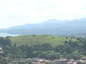
Mount Roskill from Big King. The Waitākere Ranges in the background.
|
|
| Country | New Zealand |
| Local authority | Auckland |
| Electoral ward | Albert-Eden-Puketāpapa ward |
| Local board | Puketāpapa Local Board |
| Area | |
| • Land | 742 ha (1,834 acre) |
| Population
(June 2023)
|
|
| • Total | 28,010 |
|
|
||
Mount Roskill (Māori: Puketāpapa) is a lively suburban area in the big city of Auckland, New Zealand. It gets its name from a volcanic hill called Puketāpapa, which many people also call "Mount Roskill."
Contents
What's in a Name? The Story of Mount Roskill
The name Mount Roskill first appeared on a map in 1841. It was originally called "Mt Rascal." No one is quite sure why it was called that. One old story says it was named after a thief. This thief supposedly used the hill to graze sheep and cattle that he had stolen!
The hill was also sometimes called Mount Kennedy. This was after a landowner named Alexander Kennedy. The name Mount Roskill became official around 1867. This was when a local government group was formed. They called themselves the Mt Roskill Highway Board. Newspapers started using "Mount Roskill" to describe the whole area in the late 1860s.
Land and History of Mount Roskill
How the Land Was Formed
The volcanic hill Puketāpapa erupted about 20,000 years ago. Before that, another volcano, Ōwairaka / Mount Albert, also erupted. These eruptions changed the path of the Oakley Creek. This caused the land between the two hills to become a peaty swamp. A peaty swamp is a wet, spongy area with lots of decaying plants.
Where is Mount Roskill Located?
Mount Roskill is in the southern part of the Auckland isthmus. This is a narrow strip of land connecting two larger landmasses. It's about seven kilometres south of the main Auckland city centre. Mount Roskill is surrounded by other suburbs. These include Three Kings, Sandringham, Wesley, Hillsborough, and Mount Albert. The main shops in Mount Roskill are found where Mount Albert and Dominion Roads meet.
Early History and First Settlers
People have lived in this area for a very long time. Tāmaki Māori iwi (tribes) and hapū (sub-tribes) settled here. They arrived as early as the 13th century. The Oakley Creek, also known as Te Auaunga, was an important resource. It provided crayfish, eels, and weka (a type of bird) for food. Harakeke (New Zealand flax) and raupō (bulrushes) grew along the creek. These plants were used to make Māori traditional textiles.
By the early 1700s, the area was part of the land of Waiohua. During this time, Puketāpapa hill was a fortified pā. A pā was a Māori village or settlement with strong defenses. After a chief named Kiwi Tāmaki was defeated, the area became part of Ngāti Whātua's land. Today, this group is known as Ngāti Whātua Ōrākei. In the early 1800s, Ngāti Whātua mainly lived in Onehunga and Māngere. They used the Mount Roskill area for seasonal activities.
European Settlement and Farming
Mount Roskill was part of a land sale in 1841. This sale was between Ngāti Whātua and the Crown. In 1845, Alexander Kennedy bought much of the land. He then sold it to Joseph May in 1849. More land was sold to settlers in 1848 and 1849. By the late 1800s, the area had become farmland.
Wealthy families owned large country estates here. Joseph May's estate, for example, later became the Akarana Golf Clubhouse. Early settlers found Mount Roskill was good for raising ducks and geese. It also had plenty of water for cattle. The northern part, near Three Kings, had fertile land. However, the southern part along Hillsborough ridge was not as good for farming.
In the early 1900s, Mount Roskill became known for its strawberry farms. William Johnston and Teddy Edwards were famous strawberry farmers. After World War I, many soldiers returned home. Some set up strawberry farms that didn't do well. This caused the strawberry market to crash about ten years later. In the 1920s, Chinese New Zealanders Quong Sing and Wong Key started market gardens in Mount Roskill. These gardens grew vegetables for sale.
Growing into a Suburb
Private housing areas started to develop in Mount Roskill in the 1920s. One of the first was the Victory Estate. It was built near Dominion Road. Then came the Winstone Estate, which grew at the foot of Puketāpapa from 1932.
In 1930, the Auckland tramway network was extended. Trams ran south along Dominion Road to Mount Albert Road. This new tram stop became a shopping centre. Today, it's known as the Mount Roskill Town Centre. From 1939, the New Zealand Government started building many public houses. Land at the end of tram lines was cheaper to develop. By 1947, 1,085 new houses were built. By 1953, this number grew to 2,529. About 600 houses were part of a government project. This was at the Lower Wesley Estate, west of Three Kings.
Mount Roskill became a borough in 1947. This meant it had its own mayor and local council. They could now invest more in the area. One of their first challenges was improving stormwater systems. This was for houses near the Oakley Creek. There were big floods in Wesley in 1948 and 1953.
In the 1950s, Mount Roskill was known as Auckland's "Bible Belt." This was because of its conservative Presbyterian mayor, Keith Hay. Also, the area had the most churches per person in New Zealand.
Over time, Mount Roskill changed. Many new people moved in, including migrants and refugees. This made the area very multicultural. The 2006 movie No. 2 was filmed in Mount Roskill. It was inspired by the director Toa Fraser's own experiences growing up in this diverse place.
In 1999, Mount Roskill became one of the last places in New Zealand to allow alcohol sales. Before that, it was a "dry" area where selling alcohol was not allowed.
In the early 2000s, work began on extending the Southwestern Motorway. This motorway was extended north of Hillsborough. To make way for the new road, 120 properties in Mount Roskill were bought.
Mount Roskill Today: People and Community
Mount Roskill is a busy place. It covers about 7.42 square kilometres. As of 2023, it has an estimated population of 28010 people. This means there are about 3775 people living in each square kilometre!
Mount Roskill is known for its diverse community. Many people from different backgrounds live here. In 2018, about 56% of the people living in Mount Roskill were born overseas. This is much higher than the national average of 27%.
The community is made up of many different ethnic groups:
People in Mount Roskill also have many different religious beliefs. In 2018, 31.5% had no religion. 34.1% were Christian. There were also significant numbers of Hindu (15.8%), Muslim (8.8%), and Buddhist (2.4%) people.
Community Hubs and Fun Places
- The Fickling Convention Centre is a big community building. It opened in 1976. It has the community library, a Citizens Advice Bureau, and Fickling Hall. It's named after Dick Fickling, a former mayor.
- Mt Roskill Library opened in August 1977. It was updated in 2011. The library has books in English, Māori, Chinese, Tamil, Arabic, and Somali.
- Sports clubs in the area include the Mount Roskill Rugby Football Club, Bay Roskill Vikings (rugby league), and Eden Roskill District Cricket Club.
Schools in Mount Roskill
Mount Roskill has several schools that serve the community:
- Mount Roskill Grammar School is a high school for students in years 9–13. It has about 1,797 students. It opened in 1953.
- Mount Roskill Intermediate is for years 7–8. It has about 523 students. It opened in 1956.
- Mount Roskill Primary is a primary school for years 1–6. It has about 553 students. It opened in 1955.
These three schools are all located next to each other.
Other primary schools in the area include:
- Dominion Road School (years 1–6) with about 218 students. It opened in 1929.
- Hay Park School (years 1–6) with about 132 students. It opened in 1963.
- May Road School (years 1–6) with about 165 students. It opened in 1925.
- Monte Cecilia School is a Catholic primary school (years 1–6). It has about 140 students. It opened in 1925 as a private school.
All these schools welcome both boys and girls. Student numbers are from February 2024. .
Famous Faces from Mount Roskill
Mount Roskill has been home to many successful New Zealanders. Many of them attended the local schools. Here are some of them:
- Rugby coach John Hart
- Billionaire Graeme Hart
- Evangelist Bill Subritzky
- Rugby union international Doug Howlett
- Actor and South Sydney Rabbitohs owner Russell Crowe
- Reserve Bank Governor Alan Bollard
- Tennis player Brett Steven
- Labour MP Phil Goff
- Rugby league international and former Kiwi coach Gary Freeman
- Former rugby league international Dane O'Hara
- Former rugby league international Bill Burgoyne
- Rugby league international and NRL referee Henry Perenara
- Former rugby league player Marcus Perenara
- Rugby league international Steve Matai
- New Zealand Warriors captain and rugby league international Monty Betham
- Rugby league international Matt Utai
- Rugby league international Evarn Tuimavave
- Rugby league player Manu Ma'u
- Rugby league player Ben Henry
- Rugby league player Bill Tupou
- Rugby league player Sosaia Feki
- Rugby league player Simi Sasagi
- Rugby league player Sione Lousi
- Rugby league player Sam Lousi
- Rugby league player Paterika Vaivai
- The Hay family, known for Keith Hay Homes
- Professional cricket player Azhar Abbas
- New York Times Best Selling author Nalini Singh
In 2007, a book called Just Passing Through: A History of Mt Roskill was written. It covered the history of the area from 1840. It also highlighted how Mount Roskill residents have made a big impact internationally. For example, athletics coach Arthur Lydiard was featured in a chapter about how sport put Mount Roskill on the world map.
 | Jessica Watkins |
 | Robert Henry Lawrence Jr. |
 | Mae Jemison |
 | Sian Proctor |
 | Guion Bluford |


