
Kohimarama facts for kids
Quick facts for kids
Kohimarama
|
|
|---|---|
|
Suburb
|
|

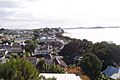
View of Kohimarama Beach
|
|
| Country | New Zealand |
| Local authority | Auckland |
| Electoral ward | Ōrākei ward |
| Local board | Ōrākei Local Board |
| Area | |
| • Land | 152 ha (376 acre) |
| Population
(June 2023)
|
|
| • Total | 4,400 |
|
|
||
Kohimarama is a suburb in Auckland, New Zealand. It's located right by the coast, east of the city center. You can find Kohimarama between two other suburbs, Mission Bay and St Heliers.
This area has a lovely beach where you can relax. There's also a boardwalk for walks and green spaces for playing. The local government for Kohimarama is the Ōrākei Local Board. This board helps manage things for Kohimarama and other nearby suburbs like Ōrākei and Mission Bay.
Contents
About Kohimarama's People
Kohimarama is about 1.52 square kilometers in size. In June 2023, around 4400 people lived here.

The population has grown over the years. In 2018, there were 4,350 people living in Kohimarama. This was an increase of 207 people since 2013.
Most people in Kohimarama are of European (Pākehā) background. However, there are also people from Māori, Pacific, and Asian backgrounds. This mix of cultures makes Kohimarama a diverse place! About 35.8% of the people living here were born outside of New Zealand.
A Look at Kohimarama's Past
The name "Kohimarama" originally belonged to Bastion Point. This important place is now called Takaparawhau by its owners, the Ngāti Whātua Ōrākei people.
Before it was called Kohimarama, this area was known as Waiparera. This Māori name means 'duck water'. It was called this because many wild grey ducks (pārera) used to breed here. Both Māori and Pākehā (European New Zealanders) used this name until 1870.
Kohimarama was once part of a large piece of land. This land was sold by the Māori Ngāti Pāoa iwi (tribe) in 1841. The price was 200 pounds, which was considered very low even back then.
In 1841, William Field Porter became the first European settler in what is now Kohimarama. He worked to clear and drain the land. At that time, the area had a lagoon, a swamp, and a long beach.
Early Developments
The Kohimarama Wharf was built in 1912. It was located between Kohimarama and Mission Bay. A tearoom opened nearby, serving people who arrived at the new wharf. Walking to the wharf was tricky because of the rocks. This led to the building of the road we now know as Tamaki Drive.
From 1892 to 1919, Kohimarama was also called 'Jockey Bay'. This was because the area was used to train racehorses. Later, the horse stables moved, and the land was used by a dairy farmer named W.H. Madill.
Today, Kohimarama beach is a quieter spot along Tamaki Drive. You can find cafes along the beachfront. The Kohimarama Yacht Club is also here. It was started in 1939 for young sailors.
Protecting the Coast
In 2009, the Auckland City Council spent a lot of money to protect the beautiful pōhutakawa trees. They fixed the eroding sea wall. A new boardwalk was built, and sand was brought in from another beach. They also built special rock formations to help protect the coast. These formations were designed to blend in with the natural cliffs.
Nature Spots in Kohimarama
Kohimarama has several lovely nature reserves where people can enjoy the outdoors:
- Madills Farm Recreation Reserve: This used to be part of a dairy farm. It now has four playing fields where people can play sports.
- Mary Atkin Reserve: Named after a missionary's daughter, this is an open green space. It's a great place to walk dogs.
- Kohimarama Beach Reserve: This reserve is perfect for swimming. It's located east of the Kohimarama Yacht Club. Boat races are sometimes held here. It also has boat ramps, bicycle stands, and toilets.
- Sage Road Reserve and Speight Road Reserve: These reserves provide access to Madills Farm Recreation Reserve.
Learning in Kohimarama
Kohimarama has good schools for students of different ages:
- Selwyn College is a secondary school for students in years 9 to 13.
- Kohimarama School and St Thomas's School are primary schools for students in years 1 to 8.
All these schools welcome both boys and girls.
Sports and Clubs
Kohimarama is home to the football (soccer) club Eastern Suburbs AFC. This club has even won championships!
Other sports clubs in the area include:
- The Kohimarama Tennis Club
- The Kohimarama Yacht Club
- The Kohimarama Bowling Club: This club used to be just for women, but in 2013, they changed their rules to allow men to join too.
Gallery
-
Kohimarama
-
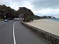
Kohimarama beach and Tamaki Drive
-
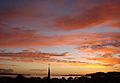
Sunrise on 1 May 2009
-
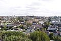
Kohimarama


