
Mission Bay, New Zealand facts for kids
Quick facts for kids
Mission Bay
|
|
|---|---|
|
Suburb
|
|

View of Mission Bay Beach
|
|

Mission Bay
Location in New Zealand
|
|
| Country | New Zealand |
| Local authority | Auckland |
| Electoral ward | Ōrākei ward |
| Local board | Ōrākei Local Board |
| Area | |
| • Land | 154 ha (381 acre) |
| Population
(June 2023)
|
|
| • Total | 4,500 |
|
|
||
Mission Bay is a lively beachside area in Auckland, New Zealand. It's a popular spot for families and friends to visit. You'll find it on the North Island, about seven kilometres east of Auckland's city centre.
The area is famous for its beautiful beach and many places to eat. It sits along Tamaki Drive, a scenic road by the sea. Mission Bay is located between the suburbs of Ōrākei and Kohimarama. It covers an area of about 1.08 square kilometres, with hills sloping down to the sea. The local decisions for Mission Bay are made by the Ōrākei Local Board.
Contents
What is the History of Mission Bay?


Mission Bay got its name from the Melanesian Mission. This mission was started by Bishop George Augustus Selwyn in the late 1840s. The mission had a school, also called St Andrew's College. It was set up to give Melanesian boys a Christian education. The old stone buildings you can still see today were built in 1858. They were made from scoria rock, which came from the volcanic island of Rangitoto.
The Kohimarama Conference
In 1860, an important meeting called the Kohimarama Conference happened at the mission buildings. The Governor, Colonel Thomas Gore Browne, invited about 200 rangatira (Māori chiefs) from all over New Zealand. The goal was to talk about the Treaty of Waitangi and how the government and Māori leaders could work together. This conference was special because it was one of the first times Māori leaders and Pākehā (European) officials met to discuss important issues.
Mission Bay and Early Aviation
Mission Bay was also a key place for early aviation in New Zealand. From 1915, the Walsh Brothers New Zealand Flying School used the bay. They used it as a landing spot for their seaplanes. Many pilots who flew in the First World War were trained here. Because of this, Mission Bay was sometimes called 'Flying School Bay'. The school trained over 1,000 pilots before it closed in 1924.
What Happened to the Mission Buildings?
The Anglican Mission moved away in 1867. The St. Andrew's College buildings were later used for different schools, including a naval training school. In 1928, the mission building became a museum. Today, the historic St. Andrew's College building is looked after by Heritage New Zealand and is now a restaurant.
What Shops and Services are in Mission Bay?
Mission Bay has two main shopping areas.
Mission Bay Waterfront Shops
The shops right by the waterfront are called the Mission Bay Shopping Precinct. It has about 44 different shops and places to eat. There's even a four-screen Reading Cinema where you can watch movies.
Eastridge Shopping Centre
On the upper side of Mission Bay, you'll find the Eastridge Shopping Centre. This centre has 32 stores, including a New World supermarket for groceries.
What are the Famous Landmarks in Mission Bay?
Mission Bay has some cool spots to visit.
Trevor Moss Davis Memorial Fountain
This beautiful fountain is a main feature of the Mission Bay Reserve. It was given as a gift by Eliot Davis to remember his son, Trevor Moss Davis, who passed away in 1947. The fountain was designed by George Tole and built by Richard Gross. It's made of white marble and has three bronze sea monsters that spout water. At night, the fountain lights up with a colourful show. In summer, kids sometimes play in the shallow water.
Parks and Green Spaces
Mission Bay is home to lovely parks where you can relax and play.
Selwyn Reserve
This is the big green space between Tamaki Drive and Mission Bay Beach. It's often called Mission Bay Reserve. It's named after Bishop George Augustus Selwyn. This reserve and the beach are very popular spots in Auckland. During summer, you might find music, art, and sports events happening here.
Kepa Bush Reserve
Beyond the beach, Mission Bay also has the Kepa Bush Reserve. This reserve is a small area of native bush. It's full of birds during the day. At night, you might even see glow-worms in the gully near the main entrance! The reserve is named after Te Keepa Te Rangihiwinui, a Māori military leader. He was also known as Major Keepa and fought alongside government forces during the New Zealand Wars in the 1860s.
What is the Population of Mission Bay?
Mission Bay covers about 1.54 square kilometres. As of 2023, it has an estimated population of about 4,600 people.
Who Lives in Mission Bay?
According to the 2018 New Zealand census, Mission Bay had 4,341 people living there.
- About 14% of the people were under 15 years old.
- Most people (78.1%) identified as European/Pākehā.
- Other groups included Māori (4.3%), Pacific peoples (1.8%), and Asian (17.7%).
- About 39% of the people living in Mission Bay were born overseas.
What Schools are in Mission Bay?
The main high schools for students in Mission Bay are Selwyn College and Glendowie College.
Gallery
-
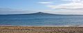
View of Rangitoto from Mission Bay
-
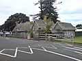
Melanesian Mission House
-
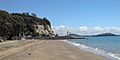
View of Mission Bay Beach looking west
-
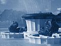
Mission Bay Fountain


