Whau River facts for kids
Quick facts for kids Whau River |
|
|---|---|

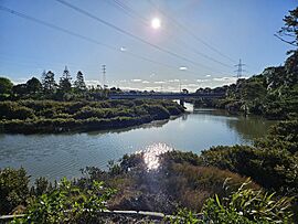
The Whau River and Rata Street Bridge
|
|
|
Mouth of the Whau River
|
|
| Country | New Zealand |
| Region | Auckland Region |
| Physical characteristics | |
| Main source | Maungakiekie Golf Club, Mount Roskill 36°55′21″S 174°43′42″E / 36.9225°S 174.72822°E |
| River mouth | Waitematā Harbour 36°51′35″S 174°39′30″E / 36.85959°S 174.6582°E |
| Basin features | |
| Progression | Whau River → Waitematā Harbour → Hauraki Gulf → Pacific Ocean |
| Tributaries |
|
The Whau River is a special waterway in Auckland, New Zealand. It's not a typical river, but more like a long arm of the Waitemata Harbour. This means it's a place where fresh water from streams mixes with salty ocean water.
The Whau River flows north for about 5.7 kilometers (3.5 miles). It starts where the Avondale Stream and Whau Stream meet. It then opens up into the Waitemata Harbour. This happens between the Te Atatū Peninsula and the Rosebank Peninsula in Avondale. At its widest, the river is about 800 meters (2,600 feet) across. At its mouth, it is about 400 meters (1,300 feet) wide.
This waterway passes by suburbs like Glendene and Kelston. It has smaller streams that flow into it, like the Wairau Creek. The ocean tide reaches far up these smaller streams. The area where the Whau River meets the harbour is a protected place. It is called the Motu Manawa (Pollen Island) Marine Reserve.
The river gets its name from a native New Zealand tree. This tree is called the whau (Entelea arborescens).
Contents
Exploring the Whau River's Surroundings
The land around the Whau River is made mostly of sand, mud, and other materials. These were brought by the sea and smaller rivers over a very long time. Along the riverbanks, you can often see mangrove trees. These special trees can grow in salty water. You might also spot some plants that are not native to New Zealand.
The Whau River's Water Collection Area
The area that collects rainwater for the Whau River is called its catchment. This catchment covers about 29 square kilometers (11 square miles). It includes many suburbs in Auckland. Some of these are Te Atatū South, Glendene, Kelston, and New Lynn.
The land in this catchment is made of clay, sandstone, and mud. It was formed about 20 million years ago. This happened when the land slowly rose up from the sea.
A Journey Through Whau River's Past
The Whau River has a rich history. It has been important to people for hundreds of years.
Early Māori Travel and Settlements
Long ago, the Māori people used the Whau River as a special travel route. They called it Te Tōanga Waka, which means "the canoe portage". This route helped them travel between the Waitemata Harbour on the east coast and the Manukau Harbour on the west coast.
Māori paddled their canoes up the Whau River and Avondale Stream. Then, they carried their canoes a short distance over land to Green Bay. This connected the two large harbours. Today, a road called Portage Road reminds us of this ancient path. Māori also had seasonal homes near the river's mouth.
Dreams of a Canal
After European settlers arrived, people often talked about building a canal. This canal would connect the Whau River to the Manukau Harbour. Plans were made in 1907 for a canal about 2.1 kilometers (6,900 feet) long. However, these plans were stopped in 1921 because it would have been too expensive to build.
Industries and Transport on the River
From 1841, people cut down Kauri trees along the riverbanks. In 1852, the first brick factory in West Auckland opened on the Rosebank Peninsula. Many other clay and brick factories followed. By the early 1900s, the Whau River area was a major center for these industries.
The river was also used for transporting goods. By 1865, there were five public docks in New Lynn. Boats carried bricks, leather, glue, and firewood. The last commercial boat, a flat-bottomed scow named Rahiri, stopped using the river in 1948.
For many years, some factories released their used water into the Whau River. This caused pollution.
Protecting and Restoring the River
In 1999, a group called Friends of the Whau Inc. was formed. Their goal was to help the river's environment. They worked to plant new trees and reduce pollution. Later, in 2012, the Whau River Catchment Trust was also created to continue this important work.
Recreation and Local Government
The West End Rowing Club has used the Whau River for rowing since 2001.
The Whau River used to be a border between two different local government areas. These were Waitakere City and Auckland City. In 2010, all the Auckland councils joined together. Now, the areas next to the river are managed by the Whau ward.
The Te Whau Pathway
In 2015, work started on the Te Whau Pathway. This is a path for walking and cycling. It runs along the western side of the Whau River. The pathway connects Te Atatū Peninsula to Olympic Park in New Lynn. The plan is for the path to eventually reach Green Bay beach. This will create a full connection between the Waitemata Harbour and the Manukau Harbour for walkers and cyclists.
 | George Robert Carruthers |
 | Patricia Bath |
 | Jan Ernst Matzeliger |
 | Alexander Miles |


