Te Atatū South facts for kids
Quick facts for kids
Te Atatū South
|
|
|---|---|
|
Suburb
|
|

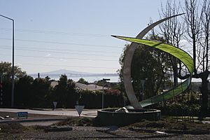
Wade Cornell Sculpture, Te Atatū South roundabout. This roundabout has since been replaced by traffic lights.
|
|
| Country | New Zealand |
| Local authority | Auckland |
| Electoral ward | Waitākere ward |
| Local board | Henderson-Massey Local Board |
| Area | |
| • Land | 455 ha (1,124 acre) |
| Population
(June 2023)
|
|
| • Total | 16,630 |
|
|
||
Te Atatū South is a friendly neighbourhood, or suburb, located in West Auckland, New Zealand. It's a great place to live because it's easy to get to the main city of Auckland and the nearby town centre of Henderson. From its higher spots, you can enjoy amazing views of the city and the Waitākere Ranges. This suburb is part of the Te Atatū Peninsula, with water on both its eastern and western sides. Along these coasts, you'll find cool walkways and cycleways for exploring.
Contents
Geography and Nature
Te Atatū South sits on land made from Waitemata Sandstone. This rock formed on the ocean floor about 20 million years ago! On top of this, there's rich soil left behind by ancient rivers.
The suburb is bordered by two "drowned valleys." To the west, you'll find the Te Wai-o-Pareira / Henderson Creek, and to the east, the Whau River. These are like old river valleys that got filled with water. The Northwestern Motorway marks the northern edge of Te Atatū South, separating it from Te Atatū Peninsula (which used to be called Te Atatū North).
Local Ecosystems
Te Atatū South is part of the Tāmaki Ecological District. Most of the area is a "Warm Lowlands Ecosystem." Long ago, this land was covered in thick forests. You would have seen huge kauri trees, tall rimu, bright red rātā, and other native trees like kahikatea and rewarewa.
Near the Whau River in the south-east, there's a "Harbour Coastline Ecosystem." This area also had diverse forests. Here, you might have found beautiful pōhutukawa trees, pūriri, nīkau palms, mamangi, and yellow-flowered kōwhai.
A Look Back in Time
Before Te Atatū South became a suburb with many homes, it was mostly farmland. People grew grapes in vineyards, raised chickens on poultry farms, and had orchards full of fruit trees like apples and lemons. There were also flower farms.
You could find vineyards along Te Atatu, McLeod, and Edmonton Roads. There was even a place that made bricks under what is now the Whau River bridge, and a timber mill at the end of Roberts Road.
How Te Atatū South Got Its Name
The name "Te Atatū South" was given to this area in 1961. This happened when the original Te Atatū area was split in two by the new Northwestern Motorway (State Highway 16).
After the motorway was built, the area quickly changed from rural farmland to a busy suburb in just 10 years. While one builder, "Neil Homes," built most of the new houses in Te Atatū Peninsula, Te Atatū South had a wider variety of new homes. Many of these were larger, high-quality family homes. This showed that Te Atatū South was one of the wealthier areas in West Auckland during the 1970s and 1980s.
Today, the suburb is still growing and improving. Roads and the town centre are being updated to create a more friendly and lively community where people can easily walk around.
Community and People
Te Atatū South covers about 4.55 square kilometres. As of June 2023, around 16630 people live here.
In the 2023 New Zealand census, Te Atatū South had 15,339 residents. This was a small increase from the 2018 census. The average age of people living here was 35.2 years. About one-fifth of the population was under 15 years old.
People in Te Atatū South come from many different backgrounds. Many identify as European, Māori, Pasifika, or Asian. English is the most common language spoken, but many other languages are also used. About 40% of the people living here were born outside New Zealand.
Schools in Te Atatū South
Te Atatū South has several schools for different age groups. All schools here welcome both boys and girls. The student numbers are from February 2024. .
- Rangeview Intermediate School is for students in Years 7 and 8. It has about 389 students and opened in 1968.
- For younger students (Years 1–6), there are four primary schools:
* Flanshaw Road School with about 299 students. * Tirimoana School with about 606 students, which opened in 1969. * Freyberg Community School with about 343 students. This school is named after Bernard Freyberg, a famous New Zealander. * Edmonton Primary School with about 212 students.
- Arohanui School helps students aged 5 to 21 who have learning disabilities. It has about 215 students. Some of these students also attend other local schools.
- The main high school for the area is Rutherford College. It's just north of Te Atatū South, in Te Atatū Peninsula.
Parks and Green Spaces
Te Atatū South is full of great places to get outside! You'll find many walkways, parks, reserves, and sports areas.
- Both sides of the suburb have coastal walkways. The Twin Streams Pathway is on the western side, and the Te Whau Pathway is on the eastern side.
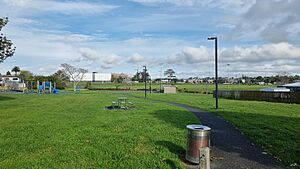
- Te Atatū South Park has sports fields, a walking track, fitness equipment, and a playground.
- McLeod Park also offers sports fields, a playground, and a walking track.
- Nearby, Tui Glen Reserve is famous for its Tree Top playground and picnic spots.
- The Trusts Stadium is close by, with a running track, gym, and other sports facilities.
- The Te Atatū Boat Club is a good place to launch boats and kayaks.
Sports in Te Atatū South
Te Atatū South is home to several sports clubs:
- Waitemata AFC is a local football club.
- West City Baseball Club is New Zealand's oldest baseball club.
- There are also fields for the Waitakere Rugby club.
- The Te Atatu Boating Club has been around since 1959.
Main Areas and Transport
Main Centres
The main hub of Te Atatū South is the Te Atatū Town Centre. This is where Edmonton Road and Te Atatu Road meet. The Te Atatū South Community Centre is also located here. There's also a small area for light industries on McLeod Road.
Getting Around
- Te Atatu Road is the main road that goes through the whole suburb. Buses run along here and Edmonton Road.
- Edmonton Road connects to Henderson. It's also very close to the Henderson Railway Station.
- McLeod Road is another important road. It links the southern part of the suburb to Henderson.
- State Highway 16 (SH 16) and the Northwestern Cycleway are at the northern tip of the suburb. They connect Te Atatū South to the city centre and to areas further north. There are plans for a light rail station here in the future.
- Twin Stream Walkway/Cycleway is on the western side. It runs along Te Wai-o-Pareira / Henderson Creek from the Northwestern cycleway all the way to Henderson's Twin Streams.
- Te Whau Pathway (still being built) is a walkway and cycleway on the eastern side, along the historic Whau River. When it's finished, it will connect Te Atatū to Green Bay. This will create a path between the Manukau and Waitemata Harbours!
- A Ferry Service has been suggested to connect the suburb to the city centre by water.
Interesting Buildings and Landmarks
Te Atatū South has some buildings with cool stories:
- 36 Te Atatu Road: This large, two-storey home was built in the 1930s for the wealthy Ryan family. It was once home to the Henderson Tennis Club. In 1955, it became a maternity hospital. Today, it's used for other businesses.
- Coop's Store - 104 McLeod Road: Built in the 1920s, this was the only store serving the area for a long time. It has always been a shop and is still open today as a café and food spot. You can find it at the corner of McLeod Road and Te Atatu Road.
- 111 McLeod Road (Women's Centre): This building was constructed in 1924. It used to be the home of a pilot named Bob Johnson. Look closely at the front door, and you'll see a stained-glass plane! Bob Johnson took many photos of the area in the 1930s.
- Ayr House - 17 Ayrton Street: This two-storey house was built from kauri wood by the Roberts Family in the 1910s. The family also had a timber factory and a lemon tree farm nearby.
- Swan Arch - Swan Arch Reserve, Central Park Drive: This arch is on the border of Te Atatū South and Henderson. It was built by Henry Swan between 1901 and 1931. Henry Swan was a lawyer who decided to live a quiet life as a recluse by the Henderson Creek for 30 years. During that time, he built this brick arch and kept an orchard.
- Te Atatū South Community Centre – 247 Edmonton Road: The original community centre opened its doors in 1968.
Famous People From Te Atatū South
Many interesting people have lived in Te Atatū South, including:
- The Brooke Family – a famous rugby family, including All Blacks Zinzan Brooke and Robin Brooke.
- Sir Graeme Douglas – who started Douglas Pharmaceuticals.
- Marina Erakovic – a talented tennis player.
- Shayne Elliott – the Chief Executive of ANZ Group.
- Michael Erceg – who founded Independent Liquor.
- Jan Hellriegel – a singer and songwriter.
- Sir Michael Jones – another legendary All Black.
- Kees Meeuws – also an All Black.
- Paula Morris – a well-known writer.
- John Rowles – an OBE recipient and singer.
- Pio Terei – an actor, singer, comedian, and TV presenter.
- Paul Urlovic – a former All White (New Zealand football player).
- Ivan Vicelich – the All White with the most international games played.
 | Delilah Pierce |
 | Gordon Parks |
 | Augusta Savage |
 | Charles Ethan Porter |


