Medlands Beach facts for kids
Quick facts for kids
Medlands Beach
|
|
|---|---|

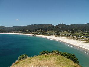
Medlands Beach, seen from the Sugar Loaf hill
|
|
| Country | New Zealand |
| Region | Auckland Region |
| Ward | Waitematā and Gulf ward |
| Local board | Aotea / Great Barrier Local Board |
| Electorates |
|
| Area | |
| • Total | 6.04 km2 (2.33 sq mi) |
| Population
(June 2023)
|
|
| • Total | 90 |
| • Density | 14.9/km2 (38.6/sq mi) |
Medlands Beach is a beautiful spot on the east coast of Great Barrier Island in New Zealand. It's located in Oruawharo Bay, which is part of the Auckland Region. The Auckland Council says it's the easiest beach to get to on the whole island!
Medlands Beach is a popular place for visitors, but it's not very crowded or built up. The small community of Medlands has a mix of homes where people live all the time and holiday houses, called baches (pronounced "batch-es"), which are like small cabins or holiday homes. Some of these homes are tucked away behind sand dunes, safe from the wind, while others are built higher up to give amazing views of the sea.
Contents
Exploring Medlands Beach
Medlands Beach is just south of Kaitoke Beach. In between them, you'll find Sugar Loaf hill and Pitokuku Island. Sugar Loaf hill offers fantastic views of the beach, but it's on private land, so you need permission to climb it. Luckily, you can still get great views from the road that connects Medlands to Claris!
The beach itself is a long stretch of white sand, about 2.1 kilometres (that's about 1.3 miles) long. You can walk the whole beach and back in about 90 minutes. About halfway along, you'll see a special spot called Memory Rock, also known as Medlands Rock. There's a short path you can follow to the top for lovely views across the bay.
Fun Things to Do at Medlands Beach
If you love to surf, the northern end of Medlands Beach has an exposed surf break. This means it often has good waves for surfing throughout the year.
At the south-eastern end of the beach, there's a calm spot called Shark Alley. Don't worry about the name – it's a great place for swimming and launching small boats! A little stream flows into the sea here, and you might even spot some pāteke, which are special brown teal ducks.
The Department of Conservation has a campsite at Shark Alley. It can host up to 120 people, especially busy from Christmas until mid-February.
Community and Services
Medlands is home to St John's Community Church, which is the only traditional church building on Great Barrier Island. It's used by different church groups.
While Medlands has places to stay, like holiday homes and guesthouses, it doesn't have any grocery stores or restaurants. For those, you'll need to drive about 4 kilometres (about 2.5 miles) to Great Barrier Aerodrome or Claris. Claris is a small town with a general store, a Post shop, a petrol station, and other useful services.
Who Lives in Medlands Beach?
Statistics New Zealand describes Medlands Beach as a rural settlement. In 2018, about 75 people lived there. The area covers about 6.04 square kilometres (2.33 square miles).
Most people living in Medlands Beach are of European/Pākehā background. A smaller number are Māori or from other ethnic groups. Many people in Medlands Beach say they don't have a religion, while others are Christian.
Education in the Area
Nearby, there's a school called Kaitoke School. It's a school for students from Year 1 to Year 8 (ages 5 to 13). The school was first started in 1988.
Famous People from Medlands Beach
Some notable people who have lived in Medlands Beach include:
- Jim Allen – a famous sculptor.
- Pamela Allen – a well-known author of children's books.
 | Audre Lorde |
 | John Berry Meachum |
 | Ferdinand Lee Barnett |

