Whangārei facts for kids
Quick facts for kids
Whangārei
Whangārei-Terenga-Parāoa (Māori)
|
|
|---|---|
|
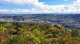
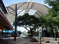
From top, left to right: Whangārei city from Mt Parihaka, Whangārei Marina, Whangārei Falls, Whangārei Mall, the entrance of the Hundertwasser Art Centre
|
|
| Nickname(s):
The Rei, Whangas
|
|
| Motto(s):
Non Nobis Solum, Love It Here, City of 100 Beaches
|
|
| Country | New Zealand |
| Region | Northland |
| Territorial authority | Whangarei District |
| Pre 1989 | Whangārei City |
| Named for | Reipae (a Waikato princess) |
| NZ Parliament | Te Tai Tokerau (Māori) Whangārei |
| Area | |
| • Urban | 63.53 km2 (24.53 sq mi) |
| Population
(June 2023)
|
|
| • Urban | 56,900 |
| • Urban density | 895.6/km2 (2,319.7/sq mi) |
| Time zone | UTC+12 (NZST) |
| • Summer (DST) | UTC+13 (NZDT) |
| Postcode |
0110, 0112 (urban)
|
| Area code(s) | 09 |
| Local iwi | Ngāpuhi, Ngāti Wai |
Whangārei (Māori: [faŋaːˈɾɛi]) is the northernmost city in New Zealand. It is the largest town in the Northland Region. Whangārei is part of the Whangarei District, which was formed in 1989. This district manages both the city and the areas around it. In 2018, about 56,900 in June 2023, people lived in Whangārei. This number has grown from 47,000 people in 2001.
Contents
Understanding the Name Whangārei
The name Whangārei has a few different stories behind it. These stories come from traditional Māori tales called pūrākau.
Stories Behind the Name
One popular story is about two sisters, Reitū and Reipae. They were from the Tainui waka (canoe) and traveled north from Waikato. They either flew on the backs of birds or changed into birds themselves.
Other stories say that Whangārei means "lying in wait to ambush." This refers to warriors who watched over the harbour from Te Tihi-o-Kahukura / Castle Rock. Another meaning could be "to gather," suggesting the harbour was a meeting place for whales or important rangatira (chiefs).
Exploring Whangārei's Past
Whangārei Harbour was an important landing spot for many migratory waka (canoes) that came to New Zealand. These included the Tūnui-ā-rangi and Te Arawa canoes. Many local stories feature the famous chief Manaia.
Early Māori Life and Trade
For a long time before Europeans arrived, Whangārei was a key trading spot. It connected the Muriwhenua iwi (tribes) from the far north with people from the Hauraki Gulf islands and Tāmaki Māori iwi in the south. There was even an overland path, the Mangapai portage. This allowed waka to be moved between Whangārei Harbour and the Wairoa River and Kaipara Harbour to the west.
Several Māori iwi were part of Whangārei's early history. These include Ngare Raumati, Ngāi Tāhuhu, Ngātiwai, and Te Parawhau. In the late 1700s, the Ngāpuhi iwi moved south into the Whangārei area.
European Arrival and Settlement
Captain James Cook and his crew on the Endeavour were the first Europeans to see the entrance to Whangārei Harbour. On November 15, 1769, they caught many fish there. Cook named the area Bream Bay after the fish they found.
In the early 1800s, more Europeans started visiting the harbour. At this time, Ngāpuhi lived in Whangārei, and the Te Parawhau hapū (sub-tribe) lived at the top of the harbour.
The first European settler was William Carruth, a trader from Scotland, who arrived in 1839. Gilbert Mair and his family joined him six years later. Settlers and local Māori usually got along well. However, in February 1842, settler farms were raided because of disrespect for tapu (sacred rules). In April 1845, during the Flagstaff War, all settlers left Whangārei. Most of them never came back.
Growth of the Town
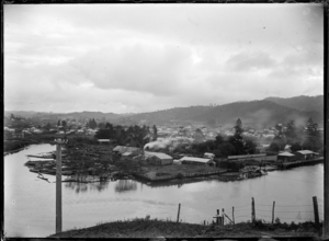
By the mid-1850s, more farmers and orchard owners moved to the area. From 1855, a small town began to grow. This growth was helped by the kauri gum trade. The 'Town Basin' on the Hatea River was the first port. Early exports included kauri gum and native timber. Later, coal from Whau Valley, Kamo, and Hikurangi was also exported. By 1864, the main part of the city we see today was established.
Fire bricks were made from clay near the Kamo mines for many years. Good quality limestone was dug up at Hikurangi, Portland, and Limestone Island. This limestone was first sold for farming. Later, it was mixed with local coal to make cement at Portland. Today, local limestone is still used for cement, but the coal comes from the West Coast of the South Island.
Whangārei was the most developed area in Northland by the late 1800s. However, it grew slowly in the 1900s. The area used up most of its natural resources but was supported by farming, especially dairy. Shipping was the main way to transport goods until the North Auckland railway line reached the town in 1925. The road from Auckland was not good for travel in bad weather until 1934. These new transport routes caused coastal shipping to decline quickly. They also helped Whangārei become the main service center for Northland.
The population was 14,000 in 1945. It grew fast in the 1960s, including Kamo and other nearby areas. In 1964, Whangārei officially became a city. Its population the next year was 31,000.
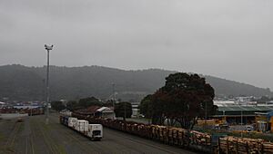
In the second half of the 1900s, an oil refinery was built and expanded at Marsden Point. Timber processing also grew, and Northland Port was set up. This port mainly exports timber.
The Hundertwasser Art Centre with Wairau Māori Art Gallery started being built in 2018. It opened in February 2022.
What's Next for Whangārei?
There are plans for a container port, connected by rail to Auckland. The large, undeveloped land around Northport could help with Auckland's growing population and need for industrial space.
Whangārei's Landscape
Natural Landmarks
Mount Parihaka is a volcanic hill that rises 259 meters (850 feet) northeast of the city center. It is part of the Whangārei volcanic field and is about 20 million years old. You can drive to the top of Parihaka, and there are walking paths through the reserve around it. A bridge connects it to Mair Park. The original Māori name, Parihaka, was confirmed by the government in 2005.
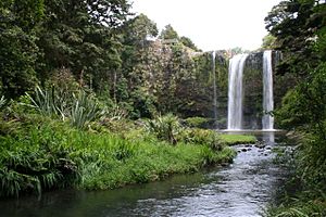
The Hatea River flows south through the city and into Whangārei Harbour. The river has a stunning 26-meter (85-foot) waterfall in Tikipunga, 6 kilometers (3.7 miles) north of the city.
Matakohe, or Limestone Island, is in the harbour close to the city. The Whangārei District owns it. A group called the Friends of Matakohe/Limestone Island Society is working to restore its natural environment.
City Neighborhoods
Whangārei Central is the main business area. The city's urban area spreads out into the valleys around it. The suburbs include:
- Northern areas: Te Kamo, Springs Flat, Tikipunga, Three Mile Bush, Otangarei, Mairtown, Regent, Kensington, and Whau Valley.
- Southern/Western areas: Morningside, Raumanga, Maunu, Horahora, Woodhill, and The Avenues.
- Eastern areas: Riverside, Port Whangārei, Sherwood Rise, Onerahi, and Parahaki.
Weather in Whangārei
Whangārei has an oceanic climate. This means the weather usually has mild differences between high and low temperatures. Summer days can sometimes get hotter than 30 °C (86 °F). There is plenty of rain, spread fairly evenly throughout the year.
| Climate data for Whangārei Airport (1991–2020 normals, 1967–present) | |||||||||||||
|---|---|---|---|---|---|---|---|---|---|---|---|---|---|
| Month | Jan | Feb | Mar | Apr | May | Jun | Jul | Aug | Sep | Oct | Nov | Dec | Year |
| Record high °C (°F) | 31.2 (88.2) |
33.5 (92.3) |
29.6 (85.3) |
27.3 (81.1) |
24.8 (76.6) |
22.6 (72.7) |
20.3 (68.5) |
22.8 (73.0) |
24.2 (75.6) |
25.3 (77.5) |
28.7 (83.7) |
31.5 (88.7) |
33.5 (92.3) |
| Mean maximum °C (°F) | 28.5 (83.3) |
28.7 (83.7) |
26.5 (79.7) |
24.8 (76.6) |
22.3 (72.1) |
20.0 (68.0) |
18.9 (66.0) |
19.6 (67.3) |
21.3 (70.3) |
23.0 (73.4) |
25.4 (77.7) |
27.3 (81.1) |
29.5 (85.1) |
| Mean daily maximum °C (°F) | 24.6 (76.3) |
24.7 (76.5) |
23.2 (73.8) |
20.9 (69.6) |
18.5 (65.3) |
16.3 (61.3) |
15.5 (59.9) |
15.9 (60.6) |
17.5 (63.5) |
19.0 (66.2) |
20.8 (69.4) |
23.0 (73.4) |
20.0 (68.0) |
| Daily mean °C (°F) | 20.2 (68.4) |
20.6 (69.1) |
19.0 (66.2) |
17.0 (62.6) |
14.8 (58.6) |
12.7 (54.9) |
11.8 (53.2) |
12.2 (54.0) |
13.5 (56.3) |
15.0 (59.0) |
16.6 (61.9) |
18.8 (65.8) |
16.0 (60.8) |
| Mean daily minimum °C (°F) | 15.8 (60.4) |
16.4 (61.5) |
14.9 (58.8) |
13.1 (55.6) |
11.2 (52.2) |
9.1 (48.4) |
8.1 (46.6) |
8.4 (47.1) |
9.6 (49.3) |
10.9 (51.6) |
12.4 (54.3) |
14.5 (58.1) |
12.0 (53.6) |
| Mean minimum °C (°F) | 11.1 (52.0) |
12.3 (54.1) |
10.5 (50.9) |
8.1 (46.6) |
5.8 (42.4) |
3.6 (38.5) |
2.6 (36.7) |
3.4 (38.1) |
4.6 (40.3) |
6.4 (43.5) |
7.9 (46.2) |
10.0 (50.0) |
2.1 (35.8) |
| Record low °C (°F) | 8.1 (46.6) |
8.7 (47.7) |
6.1 (43.0) |
4.1 (39.4) |
2.0 (35.6) |
−0.1 (31.8) |
0.0 (32.0) |
0.7 (33.3) |
1.9 (35.4) |
3.3 (37.9) |
3.5 (38.3) |
6.5 (43.7) |
−0.1 (31.8) |
| Average rainfall mm (inches) | 78.0 (3.07) |
83.2 (3.28) |
119.2 (4.69) |
94.1 (3.70) |
112.9 (4.44) |
142.2 (5.60) |
173.5 (6.83) |
130.0 (5.12) |
112.3 (4.42) |
76.8 (3.02) |
75.9 (2.99) |
90.9 (3.58) |
1,289 (50.74) |
| Average rainy days (≥ 1.0 mm) | 6.9 | 7.3 | 9.0 | 9.7 | 13.1 | 14.0 | 15.0 | 15.2 | 12.9 | 10.3 | 9.2 | 8.8 | 131.4 |
| Average relative humidity (%) | 79.0 | 84.0 | 85.9 | 86.2 | 88.3 | 89.4 | 89.0 | 86.1 | 80.9 | 81.0 | 76.9 | 77.5 | 83.7 |
| Source: NIWA Climate Data | |||||||||||||
| Climate data for Whangarei City (1991–2020 normals, extremes 1970–1988, 2015–present) | |||||||||||||
|---|---|---|---|---|---|---|---|---|---|---|---|---|---|
| Month | Jan | Feb | Mar | Apr | May | Jun | Jul | Aug | Sep | Oct | Nov | Dec | Year |
| Record high °C (°F) | 31.3 (88.3) |
34.1 (93.4) |
29.0 (84.2) |
27.1 (80.8) |
25.3 (77.5) |
22.5 (72.5) |
20.8 (69.4) |
23.0 (73.4) |
26.0 (78.8) |
25.6 (78.1) |
29.4 (84.9) |
30.8 (87.4) |
34.1 (93.4) |
| Mean daily maximum °C (°F) | 25.0 (77.0) |
25.2 (77.4) |
23.6 (74.5) |
21.3 (70.3) |
18.9 (66.0) |
16.6 (61.9) |
16.0 (60.8) |
16.4 (61.5) |
17.7 (63.9) |
19.3 (66.7) |
21.1 (70.0) |
23.3 (73.9) |
20.4 (68.7) |
| Daily mean °C (°F) | 19.6 (67.3) |
19.9 (67.8) |
18.4 (65.1) |
16.2 (61.2) |
14.2 (57.6) |
12.1 (53.8) |
11.3 (52.3) |
11.7 (53.1) |
12.9 (55.2) |
14.3 (57.7) |
16.0 (60.8) |
18.0 (64.4) |
15.4 (59.7) |
| Mean daily minimum °C (°F) | 14.2 (57.6) |
14.6 (58.3) |
13.2 (55.8) |
11.1 (52.0) |
9.5 (49.1) |
7.6 (45.7) |
6.6 (43.9) |
7.0 (44.6) |
8.1 (46.6) |
9.3 (48.7) |
10.9 (51.6) |
12.7 (54.9) |
10.4 (50.7) |
| Record low °C (°F) | 7.1 (44.8) |
7.1 (44.8) |
4.2 (39.6) |
3.7 (38.7) |
0.6 (33.1) |
−0.4 (31.3) |
−2.0 (28.4) |
−1.6 (29.1) |
0.6 (33.1) |
2.5 (36.5) |
2.2 (36.0) |
5.6 (42.1) |
−2.0 (28.4) |
| Average rainfall mm (inches) | 95.6 (3.76) |
115.9 (4.56) |
143.6 (5.65) |
130.8 (5.15) |
125.7 (4.95) |
190.1 (7.48) |
150.3 (5.92) |
150.7 (5.93) |
130.2 (5.13) |
130.2 (5.13) |
83.7 (3.30) |
93.6 (3.69) |
1,540.4 (60.65) |
| Mean monthly sunshine hours | 235.0 | 201.7 | 168.2 | 164.3 | 153.2 | 131.8 | 141.2 | 152.3 | 170.5 | 197.7 | 206.3 | 264.8 | 2,187 |
| Source: NIWA (Rainfall 1971-2000) | |||||||||||||
Who Lives in Whangārei?
The Whangārei urban area covers 63.53 square kilometers (24.53 sq mi). In 2018, its population was estimated to be 56,900. This means there were about 896 people per square kilometer.
| Historical population for Whangārei urban area | ||
|---|---|---|
| Year | Pop. | ±% p.a. |
| 2013 | 44,730 | — |
| 2018 | 51,894 | +3.02% |
| 2023 | 53,841 | +0.74% |
Population Growth and Diversity
In the 2023 New Zealand census, Whangārei's urban area had 53,841 people. This was an increase of 1,947 people (3.8%) since the 2018 census. It was also an increase of 9,111 people (20.4%) since the 2013 census.
There were 25,776 males, 27,918 females, and 147 people of other genders. The average age was 38.2 years. About 20.5% of people were under 15 years old. 18.0% were aged 15 to 29. 41.5% were aged 30 to 64, and 20.0% were 65 or older.
People could choose more than one ethnicity. The results showed:
- 68.5% European (Pākehā)
- 37.3% Māori
- 5.6% Pasifika
- 8.9% Asian
- 0.8% Middle Eastern, Latin American, and African New Zealanders (MELAA)
- 2.0% other ethnicities
English was spoken by 96.3% of people. Māori language was spoken by 9.6%. Other languages were spoken by 9.6%.
Beliefs and Education
Regarding religion, 32.9% identified as Christian. 1.4% were Hindu, and 0.4% were Muslim. 3.5% followed Māori religious beliefs. 51.6% said they had no religion.
Of those aged 15 and older, 13.8% had a bachelor's degree or higher. 55.0% had a certificate or diploma after high school. 27.1% had only high school qualifications. The average income was $35,300.
Getting Around Whangārei
State Highway 1 runs through Whangārei. This highway goes from Auckland all the way to Cape Reinga. State Highway 14 connects Dargaville to State Highway 1 in Whangārei.
Air and Sea Travel
Whangārei Airport is located 7.4 kilometers (4.6 miles) southeast of the city center, in the suburb of Onerahi.
Whangārei is served by Northport, a seaport at Marsden Point. This port mainly handles timber exports. The first two berths at Marsden Point opened in 2002. The old Port Whangārei, closer to the city, closed to commercial shipping in 2007.
Local Transport Options
In July 2013, a second road bridge over the Hatea River opened. It is a bascule bridge, which means it can lift up to let boats pass.
There are also several walking and cycling paths being built. These paths connect the city center with the outer suburbs. The Hatea Loop (Huarahi o te Whai) is a popular walkway in the city center. It connects the Town Basin, Hihiaua Peninsula, Okara, Pohe Island, and Riverside areas.
Bus Services
The Northland Regional Council runs the CityLink bus service. This service has eight urban bus routes. From October 2018, these buses also have bicycle racks. In November 2019, Whangārei was the first city to use Bee Cards for bus fares.
Intercity operates three buses a day from Whangārei. The trip to Auckland takes about 3 hours, covering 158 kilometers (98 miles). The trip to Kerikeri takes about 1 hour and 45 minutes.
Railway Connections
Whangārei is connected to Auckland and Otiria by the North Auckland line. This line is only used for freight (goods). The container transfer depot is at 33 Porowini Ave.
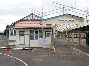
Whangārei Railway Station
The railway station stopped having regular passenger services on September 15, 1975. The station building was restored by a local Men's Shed group. Its design is protected by a Heritage New Zealand listing. The current station was opened on March 11, 1925. Earlier stations existed in 1880 and 1903.
In 1929, the fastest train from Whangārei to Auckland took 6 hours and 14 minutes. By 1956, special railcars reduced the journey to 4 hours and 10 minutes.
Arts and Culture in Whangārei
The Whangārei Art Museum is located in the Town Basin. You can find artisan markets at the nearby Canopy Bridge.
The Hundertwasser Art Centre was built where the old Northland Harbour Board building used to be.
The Quarry Arts Centre is on the edge of the Western Hills in the Avenues.
The Hātea Loop walkway is an easy-to-use circular path. It connects the Town Basin, William Fraser Memorial Park, Te Matau a Pohe bridge, Canopy Bridge, Clapham's Clocks, and Reyburn House gallery. This walkway offers great views of the marina and fun outdoor activities for families.
Performing Arts and Music
The Whangārei Theatre Company has been putting on plays since 1946. They now perform at the Riverbank Centre in the Town Basin.
Disruptive Performers is another theatre group that started in 2019.
Whangārei also has many music groups. These include Whangārei Youth Music, the Northland Sinfonia, and Sistema Whangārei.
Learning in Whangārei
Higher Education Opportunities
NorthTec is the main provider of higher education in the Northland Region. Its main campus is in the Whangārei suburb of Raumanga. NorthTec offers degrees, diplomas, and certificates in many different subjects. These qualifications are checked for quality and can lead to further study at universities. NorthTec has about 23,000 students.
The University of Auckland also has a campus in the city center. There are also private schools that offer technical and job training.
Schools in Whangārei
Most suburbs in Whangārei have their own primary school. There are also several schools that offer secondary education.
Secondary Schools
- Whangārei Boys' High School: A school for boys in years 9–13. It has about 1,398 students.
- Whangārei Girls' High School: A school for girls in years 9–13. It has about 1,561 students.
- Both of these schools opened in 1881.
- Kamo High School: A co-educational school for years 9–13.
- Tikipunga High School: A co-educational school for years 7–13.
- These two schools serve the northern suburbs.
- Huanui College: A private secondary school located just outside the city in Glenbervie.
- Te Kura Kaupapa Māori o Te Rāwhitiroa: A Māori language immersion school for both primary and secondary students.
- Pompallier Catholic College: A Catholic secondary school for years 7–13. It is located slightly west of Whangārei in Maunu.
Intermediate and Primary Schools
There are two intermediate schools (years 7–8) in the city. Many primary schools offer education from years 1–8.
- Whangārei Intermediate: An intermediate school for years 7–8 with 639 students.
- Kamo Intermediate: A popular intermediate school for the northern suburbs.
Primary schools include Hurupaki School, Kamo Primary School, Totara Grove School, Tikipunga Primary School, Otangarei School, Whau Valley School, Whangārei School, Maunu School, Horahora School, Morningside School, Manaia View School, Raurimu Avenue School, and Onerahi School.
Religious and State-Integrated Schools
Pompallier Catholic College (opened in 1971) is a Catholic co-educational secondary school for years 7 to 13. It is the only Catholic secondary school in Northland.
Saint Francis Xavier Catholic School is the city's Catholic primary school. It is located in the Whau Valley suburb.
Christian Renewal School is a school for years 1–13. It was established in 1993.
Excellere College is a Christian school for years 1–13. It is located in Springs Flat.
The Whangārei Adventist Christian School has been open for about 50 years. It is located on Whau Valley Road.
Special School
Blomfield Special School and Resource Centre provides education and care for students aged five to twenty-one. It has 68 students and operates from five locations.
City Services and Utilities
Healthcare Services
Whangārei is part of the Northland District Health Board. The main health organization, Mahitahi Hauora, was created in 2019. Whangārei Hospital is the largest hospital in Northland. It provides specialist care for the whole region. It has 246 beds and is in the Horahora suburb.
Mercy Hospital was started in 1963 by the Sisters of Mercy. Kensington Hospital is a private healthcare facility that opened in 2001.
Electricity and Gas
Northpower manages the local electricity network in the city. Electricity comes from Transpower's national grid. Most of the city's electricity comes from the Waikato region.
Natural gas arrived in Whangārei in 1983. This happened when a pipeline from Auckland was completed. First Gas now operates this pipeline and the gas network within the city.
Sports and Recreation
Whangārei is home to the Northland rugby union team. This professional team plays in the Bunnings NPC. They play at Okara Park, also known as "Semenoff Stadium." This is the largest stadium in the region. It hosted two matches during the Rugby World Cup 2011.
Cobham Oval has hosted Black Caps one-day international cricket matches. The first match took place in 2012.
The football (soccer) club North Force is based in Whangārei. They play in the Lotto Sport Italia NRFL Division 1.
Whangārei has a Field Hockey facility that has hosted international matches. Many hockey players from Northland have played for the Black Sticks Women since 2000.
Whangārei is home to the northernmost parkrun in New Zealand. This is a free, weekly 5-kilometer (3-mile) run held every Saturday. It starts and finishes under the Te Matau o Pohe bridge.
The International Rally of Whangārei takes place in the region. Drivers from many countries race on dirt roads around Whangārei. It is the first event of the Asia-Pacific Rally Championship and the New Zealand Rally Championship. It is New Zealand's second-largest international motorsport competition. Whangārei Speedway also attracts drivers from outside the Northland region.
Northland also has top-level golf players.
The Northland rugby league team represents the Northland Region. They are based in Whangārei and play as the Northern Swords.
Famous People from Whangārei
See also
 In Spanish: Whangarei para niños
 | Misty Copeland |
 | Raven Wilkinson |
 | Debra Austin |
 | Aesha Ash |


