
Tikipunga facts for kids
Quick facts for kids
Tikipunga
|
|
|---|---|
|
Suburb
|
|

|
|

Tikipunga
Location in New Zealand
|
|
| Country | New Zealand |
| Local authority | Whangārei |
| Electoral ward | Whangārei Urban Ward |
| Area | |
| • Land | 575 ha (1,421 acre) |
| Population
(June 2023)Template:NZ population data 202PA2
|
|
| • Total | 7,970 |
|
|
||
Tikipunga is one of the biggest suburbs in Whangārei, New Zealand. It is located in the north-east part of the city. A famous landmark nearby is the beautiful Whangārei Falls.
Contents
Who Lives in Tikipunga?
Tikipunga covers about 5.75 square kilometers. As of 2023, around 7970 people live here. This means there are many people living close together.
How the Population Has Grown
Tikipunga has grown a lot over the years. In 2006, about 5,763 people lived here. By 2018, this number had increased to 6,906 people. That's a big jump of over 1,400 people in just five years!
When the 2018 census was taken, there were 2,433 homes in Tikipunga. There were more females than males living in the area. Many young people lived there, with about 1,662 people under 15 years old.
Different Backgrounds and Beliefs
People from many different backgrounds live in Tikipunga. Most people are European/Pākehā. A large number of people are also Māori. There are also people from Pacific Islands and Asia. This mix of cultures makes Tikipunga a diverse place.
When asked about their beliefs, many people said they had no religion. Others were Christian. Some people followed Māori religious beliefs. A smaller number of people had other religions like Hindu or Buddhist.
Fun Things to See
Whangārei Falls
One of the most famous places near Tikipunga is the Whangārei Falls. These beautiful waterfalls have been open for everyone to visit since the 1940s. It's a great spot for a walk or to enjoy nature.
Schools in Tikipunga
Tikipunga has several schools for students of all ages. All the schools here welcome both boys and girls.
Tikipunga High School
Tikipunga High School is a secondary school for students in Year 7 to Year 13. It is located on Corks Road. The school first opened in 1971. It helps students learn and grow as they get older.
Primary Schools
Tikipunga Primary School is for younger students, from Year 1 to Year 6. It helps children start their learning journey.
There is also Te Kura Kaupapa Maori o Te Rawhiti Roa. This school teaches students from Year 1 all the way up to Year 15. It focuses on learning through Māori language and culture.
Local Shops and Services
Tikipunga has a main shopping area called Paramount Plaza. Here you can find a large Woolworths Supermarket for groceries. There's also a petrol station, places to buy food, a shop for drinks, a pharmacy, and a medical center.
The Tikipunga branch of the Whangārei Libraries is also nearby. It's a great place to find books and learn. There is also a smaller group of shops on Kiripaka Road and Spedding Road.
-
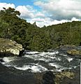
Whangārei Falls as seen from a walkway over the river.
-
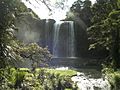
Falls from below.
.jpg)

