Dargaville facts for kids
Quick facts for kids
Dargaville
Tākiwira (Māori)
|
|
|---|---|
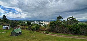
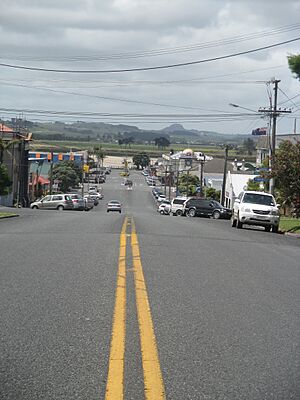
View of Dargaville from Mount Weasley (2024)
|
|
| Motto(s):
Heart of the Kauri Coast
|
|
| Country | New Zealand |
| Region | Northland Region |
| District | Kaipara District |
| Ward | Wairoa Ward |
| Electorates |
|
| Area | |
| • Total | 12.86 km2 (4.97 sq mi) |
| Population
(June 2023)
|
|
| • Total | 5,130 |
| • Density | 398.9/km2 (1,033.2/sq mi) |
| Postcode(s) |
0310
|
Dargaville (Māori: Tākiwira) is a town in the North Island of New Zealand. It sits on the bank of the Northern Wairoa River. This town is part of the Kaipara District in the Northland region. Dargaville is about 55 kilometers (34 miles) southwest of Whangārei. It is also about 174 kilometers (108 miles) north of Auckland.
Dargaville is known for having many residents of Croatian descent. The area around the town is famous for growing kūmara, which are sweet potatoes. Because of this, many locals call Dargaville the "Kūmara Capital" of New Zealand.
Contents
Discovering Dargaville's Past
The town of Dargaville was started by a timber merchant named Joseph Dargaville. He bought land from the local Māori people. Dargaville was founded in 1872. This was during a time when the kauri gum and timber trade were very busy. For a short time, Dargaville even had the largest population in New Zealand!
The area became well-known for its gum digging and kauri logging. Logs were sent down the Wairoa River to shipbuilders. The river was also the main way to travel to Auckland. Many migrants from Dalmatia (part of Croatia) worked in the kauri gum industry. After 1920, when the gum and forestry industries slowed down, farming became very important. Dairy farming, especially, helped the local economy.
The Wairoa River was the main way people and goods moved around Dargaville until the 1940s. In 2023, the Dargaville Town Hall had to be closed. It was partly taken down after being damaged by Cyclone Gabrielle.
Who Lives in Dargaville?
Dargaville is a small town. It covers about 12.86 square kilometers (4.97 sq mi). In 2023, about 5,016 people lived here. This was an increase of 189 people since 2018. The median age in Dargaville was 43.4 years.
Many different groups of people live in Dargaville. About 70.5% of people are European (Pākehā). About 37.6% are Māori. Other groups include Pasifika (9.9%) and Asian (4.7%). Most people speak English (96.7%). Some also speak Māori language (7.7%).
Exploring Dargaville's Geography
Near Dargaville is Ripiro Beach. It has the longest stretch of sand beach in New Zealand. You can often drive along the beach from one end to the other. This beach is also home to a special shellfish called the toheroa. However, too many were gathered in the 1950s and 1960s. Now, people are not allowed to collect them.
Dargaville is also the entry point to the Waipoua Forest. This is a protected national park. It is home to the biggest Kauri trees in New Zealand. The most famous one is Tāne Mahuta, which means "Lord of the Forest" in Māori.
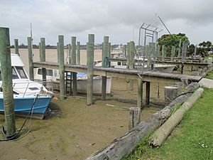
The town is next to the Wairoa River. The river has boat moorings and a central wharf. The river's water level changes with the tides. Dargaville also includes the area of Mangawhare. The Kaihu River separates these two areas.
Dargaville's Weather
Dargaville has an oceanic climate. This means it has warm summers and mild winters.
| Climate data for Dargaville (1991–2020 normals, extremes 1943–present) | |||||||||||||
|---|---|---|---|---|---|---|---|---|---|---|---|---|---|
| Month | Jan | Feb | Mar | Apr | May | Jun | Jul | Aug | Sep | Oct | Nov | Dec | Year |
| Record high °C (°F) | 31.8 (89.2) |
32.4 (90.3) |
32.1 (89.8) |
28.9 (84.0) |
24.9 (76.8) |
24.4 (75.9) |
21.7 (71.1) |
25.0 (77.0) |
24.5 (76.1) |
25.6 (78.1) |
27.3 (81.1) |
29.9 (85.8) |
32.4 (90.3) |
| Mean maximum °C (°F) | 28.1 (82.6) |
28.7 (83.7) |
27.0 (80.6) |
24.8 (76.6) |
22.3 (72.1) |
20.0 (68.0) |
18.8 (65.8) |
19.3 (66.7) |
21.2 (70.2) |
22.3 (72.1) |
24.0 (75.2) |
26.8 (80.2) |
29.2 (84.6) |
| Mean daily maximum °C (°F) | 23.3 (73.9) |
24.0 (75.2) |
22.5 (72.5) |
20.3 (68.5) |
17.9 (64.2) |
15.6 (60.1) |
14.8 (58.6) |
15.1 (59.2) |
16.4 (61.5) |
17.7 (63.9) |
19.3 (66.7) |
21.7 (71.1) |
19.1 (66.3) |
| Daily mean °C (°F) | 19.3 (66.7) |
19.8 (67.6) |
18.4 (65.1) |
16.5 (61.7) |
14.5 (58.1) |
12.4 (54.3) |
11.5 (52.7) |
11.8 (53.2) |
13.1 (55.6) |
14.3 (57.7) |
15.7 (60.3) |
17.9 (64.2) |
15.4 (59.8) |
| Mean daily minimum °C (°F) | 15.2 (59.4) |
15.5 (59.9) |
14.3 (57.7) |
12.7 (54.9) |
11.1 (52.0) |
9.2 (48.6) |
8.2 (46.8) |
8.5 (47.3) |
9.8 (49.6) |
11.0 (51.8) |
12.0 (53.6) |
14.1 (57.4) |
11.8 (53.3) |
| Mean minimum °C (°F) | 9.8 (49.6) |
10.8 (51.4) |
8.9 (48.0) |
6.2 (43.2) |
4.4 (39.9) |
1.8 (35.2) |
1.3 (34.3) |
2.5 (36.5) |
3.8 (38.8) |
6.1 (43.0) |
7.0 (44.6) |
9.0 (48.2) |
0.6 (33.1) |
| Record low °C (°F) | 4.0 (39.2) |
1.7 (35.1) |
0.0 (32.0) |
−1.3 (29.7) |
−3.3 (26.1) |
−3.3 (26.1) |
−5.0 (23.0) |
−3.3 (26.1) |
−1.9 (28.6) |
0.6 (33.1) |
2.2 (36.0) |
1.2 (34.2) |
−5.0 (23.0) |
| Average rainfall mm (inches) | 64.8 (2.55) |
55.5 (2.19) |
64.7 (2.55) |
86.7 (3.41) |
114.7 (4.52) |
124.9 (4.92) |
148.2 (5.83) |
114.6 (4.51) |
98.4 (3.87) |
77.1 (3.04) |
65.5 (2.58) |
78.9 (3.11) |
1,094 (43.08) |
| Mean monthly sunshine hours | 231.3 | 192.2 | 193.1 | 162.6 | 145.4 | 128.4 | 136.9 | 151.4 | 163.3 | 184.1 | 197.6 | 194.4 | 2,080.7 |
| Source: NIWA | |||||||||||||
Getting Around Dargaville
Roads in Dargaville
Dargaville is where State Highways 12 and 14 meet. These are important roads for travel.
Railways and Trains
A railway line called the Donnellys Crossing Section was built north of Dargaville. It helped transport logs. This line opened in 1889. It was later connected to the main national rail network in 1940. While freight trains no longer use it, a tourist train still runs on the Dargaville Branch line.
Flying to Dargaville
The Dargaville Aerodrome is an airport located near the town. It is on the banks of the Wairoa River.
Farming in the Region
The land around Dargaville is mostly used for farming. There are many dairy, beef, and sheep farms. There is also a growing industry for planted forests. A large meat processing plant, Silver Fern Farms, is located here. It employed 300 people in 2021.
Fun Things to Do in Dargaville
Lakes and Forests
The Kai Iwi lakes are about 25 kilometers (16 miles) north of Dargaville. They are great for swimming and relaxing. Further north, about 37 kilometers (23 miles) from town, is Trounson Kauri Park. This park lets you see giant kauri trees.
Beaches and Swimming
Ripiro Beach is the local beach, just 13 kilometers (8 miles) from town. It has 107 kilometers (66 miles) of rugged west coast surf. The Kauri Coast community swimming pool is at 8 Onslow Street. It's a large 50-meter outdoor pool.
Sports and Recreation
Sportsville is a big sports complex at the Dargaville Rugby Park. You can play Tennis, Soccer, Volleyball, Netball, Rugby League, and Rugby Union here. The Northern Wairoa Golf Club has an 18-hole golf course. It offers great sea views and is lined with pohutakawa trees.
Dargaville's Culture and Arts
Dargaville Museum
The Dargaville Museum Te Whare Taonga o Tunatahi is in Harding Park. It tells the story of local history. You can see exhibits about Māori history and early European settlers. There are also displays about the timber and shipping industries. The museum has a huge 16-meter-long Māori Waka (canoe). It also shows the history of the Gum diggers. Outside, you can see the masts from the Greenpeace Rainbow Warrior ship.
An old library building from 1874 is now part of the museum. It was moved and restored by volunteers. This building used to be a schoolhouse, a library, and a post office.
Local Theatre
The Dargaville Little Theatre is a group that puts on plays. They are based in an old Masonic Lodge building. The group started in 1963. In 2022, they won a special award for their original musical called 'Out of Mind'.
Circus Fun
Circus Kumarani is New Zealand's longest-running community circus in a rural area. It started in Dargaville in 2003. Circus Kumarani offers fun circus classes for kids and adults. They also help organize circus festivals in Northland and Auckland.
Machinery Museum
Next to the Dargaville Museum is the Kaipara Heritage Machinery Museum. It opened in 2001. Here, you can see many old machines and tractors. These were used for farming in the early days of the town. There's even a 120-year-old woolshed that still works!
Marae (Māori Meeting Place)
Te Houhanga Marae and Rāhiri meeting house is a traditional meeting place. It is for the Te Roroa people and the Ngāti Whātua hapū (sub-tribe) of Te Kuihi.
Cinema Fun
The ANZAC Theatre Te Whare Pikitia o Tunatahi is a cinema in Dargaville. It opened in 2013. Before that, Dargaville didn't have a cinema for over 30 years! The cinema is in the old library space of the former War Memorial Town Hall.
Important Buildings
Holy Trinity Church
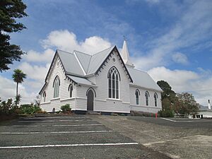
The Holy Trinity Church is an Anglican church. It was built around 1878. The church has a beautiful stained glass window facing east. This window was given in memory of Joseph Dargaville, who founded the town.
River Road Historic Area
Along River Road in Mangawhare, there are nine historic houses. They are listed as important heritage places. The Commercial Hotel and some cottages are also listed as historic.
Learning in Dargaville
Dargaville has several schools for different age groups.
- Dargaville High School is for students in years 9–13.
- Dargaville Intermediate is for years 7–8.
- Dargaville Primary School and Selwyn Park School are for years 1–6.
- St Joseph's School is a Catholic school for years 1–8.
All these schools teach both boys and girls. NorthTec polytechnic also has a campus in Dargaville. It offers different courses for older students.
Famous People from Dargaville
Many notable people have connections to Dargaville, including:
- Amelia Batistich, a writer.
- Joey Carbery, an Irish international rugby union player.
- Dion Nash, a cricketer.
- Winston Peters, a well-known politician.
- Mark Taylor, an All Black rugby player.
- Mark Williams, a singer.
 | William M. Jackson |
 | Juan E. Gilbert |
 | Neil deGrasse Tyson |


