Kaipara District facts for kids
Quick facts for kids
Kaipara District
|
|
|---|---|
|
Territorial authority district
|
|

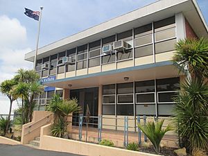
Kaipara District Council building in Dargaville
|
|
 |
|
| Country | New Zealand |
| Region | Northland |
| Wards | Dargaville West Coast-Central Otamatea Kaiwaka-Mangawhai |
| Seat | Dargaville |
| Area | |
| • Land | 3,109.09 km2 (1,200.43 sq mi) |
| Population
(June 2023)
|
|
| • Total | 27,300 |
| Time zone | UTC+12 (NZST) |
| • Summer (DST) | UTC+13 (NZDT) |
| Postcode(s) |
Map of postcodes
|
| Website | Kaipara District Council |
The Kaipara District is a special area in the Northland Region of New Zealand. It's like a local government area that helps manage the towns and communities within its borders. This district is known for its beautiful natural harbour and friendly rural communities.
Contents
History of Kaipara District
The Kaipara District was created on 1 November 1989. This happened during a big change in how local governments were set up in New Zealand.
How the District Was Formed
Before 1989, the area was made up of several smaller parts. These included all of Hobson County and Dargaville Borough. It also included Otamatea County and parts of Rodney County and Whangarei County.
The new Kaipara District brought all these areas together. It also took over the jobs of some smaller local groups. These included the Raupo Drainage Board and the Kaiwaka and Pahi Reserve Boards.
Geography of Kaipara District
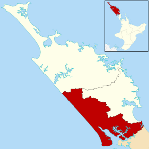
The Kaipara District is located in the Northland Peninsula. It has rolling hills and is found around the northern parts of the Kaipara Harbour. This harbour is a very large natural harbour that opens to the Tasman Sea.
Managing the Kaipara Harbour
The Kaipara District Council works with other groups to look after the harbour. These groups include the Northland Regional Council and the Auckland Council. They all work together to keep the harbour healthy and safe.
Boundaries and Rivers
The district is shaped roughly like a triangle. It stretches from south of Kaiwaka and Mangawhai in the southeast. It goes all the way to the Waipoua Forest in the northwest.
The western edge of the district is the Ripiro Beach. This long beach runs down Northland’s west coast. It goes from Maunganui Bluff and the Waipoua Forest down to Pouto. Pouto is at the entrance to the Kaipara Harbour. The Northern Wairoa River flows through the middle of the district. Its smaller rivers flow into the northern end of the Kaipara Harbour.
Communities in Kaipara District
The Kaipara District does not have one very large city. Instead, it has many towns and villages. These places are spread out among the hills or along the harbour.
Main Towns and Villages
Dargaville is the biggest town and the main service centre in the west. It is also where the district council is located. Other towns and villages include Ruawai, Matakohe, Paparoa, Maungaturoto, Kaiwaka, and Mangawhai. You can also find Tinopai, Te Kōpuru, Kaihu, and Pahi here.
The area around Dargaville has many people whose families came from Dalmatia. They have an active Dalmatian Club. The nearest big city is Whangārei, which is about 45 kilometres northeast of Dargaville.
Community Spirit
People in the rural communities of Kaipara District have a strong community spirit. They often join local clubs and volunteer groups.
For example, Dargaville has an annual Arts and Crafts Festival. This event is run by the local Rotary club. Dargaville also has weekly Riverside Produce Markets on Thursday afternoons.
Maungaturoto holds a monthly market on a Friday evening at the Maungaturoto Hall. There is also a volunteer group there called the Maungaturoto Residents Association. They work to make their town look beautiful. Similar volunteer groups exist in Ruawai and Paparoa.
Population and People
The Kaipara District covers about 3,109 square kilometres. In 2023, about 25,899 people lived here. This means there are about 8 people per square kilometre.
Population Growth
The number of people living in Kaipara District has been growing. In 2023, the population was 25,899. This was an increase of over 3,000 people since the 2018 census. It was an increase of almost 7,000 people since the 2013 census.
Age Groups
The median age in the district was 46.8 years in 2023. This means half the people were younger and half were older than this age. About 18% of the people were under 15 years old. About 24% were 65 years or older.
Ethnic Backgrounds
People in Kaipara District come from many different backgrounds. In 2023, about 83.7% of people identified as New Zealand European. About 25.4% identified as Māori. Other groups included Pasifika (4.8%) and Asian (3.6%). Some people identify with more than one ethnic group.
| Ethnicity | Population |
|---|---|
| New Zealand European |
21,687
|
| Māori |
6,579
|
| Pasifika |
1,254
|
| Asian |
927
|
| MELAA |
141
|
| Other |
384
|
| Historical population | ||
|---|---|---|
| Year | Pop. | ±% p.a. |
| 18,135 | 2,013 | — |
| 2013 | 18,963 | +0.01% |
| 2018 | 22,869 | +3.82% |
| 2023 | 25,899 | +2.52% |
Religion and Work
Many people in the district (51.9%) said they had no religion. About 34.5% were Christian. Some people also followed Māori religious beliefs or other religions.
About 42% of people aged 15 or older worked full-time. Another 16% worked part-time.
See also
 In Spanish: Distrito de Kaipara para niños
 | John T. Biggers |
 | Thomas Blackshear |
 | Mark Bradford |
 | Beverly Buchanan |


