
Dalmatia facts for kids
Quick facts for kids
Dalmatia
Dalmacija
|
|||
|---|---|---|---|
|
Historical region
|
|||
|
|||
.svg)
(striped) Gračac Municipality
|
|||
| Country | |||
| Named for | Dalmatae | ||
| Largest city | Split | ||
| Area | |||
| • Total | 12,158 km2 (4,694 sq mi) | ||
| Highest elevation
(Dinara)
|
1,831 m (6,007 ft) | ||
| Population
(2021)
|
|||
| • Total | 938,272 | ||
| • Density | 77.173/km2 (199.878/sq mi) | ||
| Demonym(s) | Dalmatian | ||
| Time zone | Central European Time | ||
| Dalmatia is not an official subdivision of the Republic of Croatia; it is a Historical region. The flag and arms below are also unofficial/historical; none are legally defined at present.
The figures are an approximation based on statistical data for the four southernmost Croatian Counties (Zadar without Gračac, Šibenik-Knin, Split-Dalmatia, Dubrovnik-Neretva). |
|||


Dalmatia (in Croatian: Dalmacija) is a beautiful historical region located on the eastern coast of the Adriatic Sea in Croatia. It's one of Croatia's four main historical areas, along with Central Croatia, Slavonia, and Istria.
This narrow coastal strip stretches from the island of Rab in the north down to the Bay of Kotor in the south. Inland, the Dalmatian Hinterland is covered by the rugged Dinaric Alps mountains. Along the coast, you'll find 79 islands and about 500 smaller islets. The biggest islands in Dalmatia are Brač, Pag, and Hvar. The largest city in Dalmatia is Split, followed by Zadar, Šibenik, and Dubrovnik.
The name Dalmatia comes from an ancient tribe called the Dalmatae. They lived in this area a very long time ago. Later, it became a large Roman province. This led to a unique culture and even its own language, called Dalmatian, which is now extinct. Over time, Slavs (mostly Croats) moved into the area. Their culture and language mixed with the existing Roman influences.
Throughout history, Dalmatia was part of different kingdoms and empires. It was part of the medieval Kingdom of Croatia. Later, much of it was ruled by the Republic of Venice for centuries. After that, it became a province of the Austrian Empire. After World War I, Dalmatia was divided. Most of it became part of Yugoslavia, with smaller parts going to Italy. After World War II, all of Dalmatia became part of Croatia within Yugoslavia. Today, it is part of the independent Republic of Croatia.
Contents
What Does the Name Dalmatia Mean?
The name Dalmatia comes from the ancient Illyrian tribe called the Dalmatae. This tribe lived in the area during ancient times. Some people think the name might be linked to an Albanian word for "sheep" or "shepherd," but this isn't fully proven.
The original name was likely Delmatia, which came from the tribe's main settlement, Delminium. The modern English name "Dalmatia" comes from its Latin form. In the past, the Venetian language, which was common here, spelled it Dalmàssia. Today, in Croatian, it's spelled Dalmacija.
The name Dalmatia is even mentioned in the New Testament of the Bible. This means its name has been translated into many languages around the world.
Where Exactly is Dalmatia?

In ancient times, the Roman province of Dalmatia was much bigger than the region we know today. It stretched from Istria in the north all the way to modern-day Albania in the south. This area shared a common culture, climate, and unique karst landscape.
How Big is Modern Dalmatia?
.svg)
Today, Dalmatia is a historical region, not an official administrative area in Croatia. Its exact size can be a bit confusing. Most people think of Dalmatia as the area that was once the Kingdom of Dalmatia under Austrian rule until 1918.
However, there are some small differences:
- The Bay of Kotor area in Montenegro was once part of Dalmatia. Today, it's part of Montenegro.
- The island of Rab and nearby small islands were part of the historical Kingdom of Dalmatia. But now, they are often linked more with the Croatian Littoral region due to their location.
- The Gračac municipality and northern Pag are sometimes included in modern definitions. However, Gračac was not traditionally part of Dalmatia.
Generally, Dalmatia is seen as the area covered by Croatia's four southernmost counties: Zadar, Šibenik-Knin, Split-Dalmatia, and Dubrovnik-Neretva.
Who Lives in Dalmatia?
The people of Dalmatia can be divided into two main cultural groups. There are the city dwellers along the coast, often called Fetivi. They share a similar culture with the people living on the Dalmatian islands, sometimes called Boduli.
These two groups have a distinct Mediterranean culture. They are different from the people living in the Dalmatian Hinterland, the inland area. These inland residents are sometimes called Vlaji.
Historically, many people in the coastal cities and islands spoke Venetian or Italian. Some even identified as Dalmatian Italians. However, over the last two centuries, the number of Italian speakers decreased a lot. Today, almost everyone identifies as Croat, but they still feel a strong connection to their regional Dalmatian identity and heritage. This strong regional identity is also seen in the Hinterland, where the unique Mediterranean style is still visible in many towns and villages.
What is Dalmatia's Geography and Climate Like?

Most of Dalmatia's land is covered by the Dinaric Alps mountain range. These mountains run parallel to the coast. This creates a special type of coastline called a "Dalmatian concordant coastline."
The climate along the coast is Mediterranean, meaning hot, dry summers and mild, wet winters. Further inland, the climate is a bit more moderate. In the mountains, winters can be cold and snowy, while summers are hot and dry.
Over many centuries, many forests have been cut down. Now, the land is often covered with bushes and shrubs. The soil is generally poor, except in some plains where grass grows naturally. These fertile areas with warm summers are good for farming. In other places, farming is difficult because of the mountains and poor soil, but olives and grapes grow well.
Dalmatia has few energy resources. Most electricity comes from hydropower plants. There are also deposits of bauxite, a mineral used to make aluminum.
Mountains, Islands, and Rivers
The largest mountains in Dalmatia include Dinara, Mosor, Svilaja, and Biokovo. The highest peak in present-day Dalmatia is Dinara, which is 1,913 meters (6,276 feet) tall.
The biggest Dalmatian islands are Brač, Korčula, Dugi Otok, Mljet, Vis, Hvar, Pag, and Pašman. The main rivers flowing through Dalmatia are the Zrmanja, Krka, Cetina, and Neretva.
The Adriatic Sea around Dalmatia has very clean water. With its many coves, islands, and channels, Dalmatia is a popular spot for nautical tourism and other types of tourism. Dalmatia also has several beautiful national parks that attract visitors. These include Paklenica (a karst river canyon), the Kornati archipelago, Krka river rapids, and Mljet island.
How is Dalmatia Divided Today?
The area of Dalmatia today roughly matches Croatia's four southernmost counties. They are listed here from north to south:
| County | County seat | Population (Census 2011) |
Ethnic Croats | Other ethnic Groups |
|---|---|---|---|---|
| Zadar | 170,017 | 157,389 (92.57%) | 12,628 (7.34%): 8,184 Serbs (4.81%) | |
| Šibenik | 109,375 | 95,582 (87.39%) | 13,793 (12.61%): 11,518 Serbs (10.53%) | |
| Split | 454,798 | 441,526 (97.08%) | 13.272 (2.92%): 4,797 Serbs (1.05%), 1,389 Bosniaks (0.31%) and 1,025 Albanians (0.23%) | |
| Dubrovnik | 122,568 | 115,668 (94.37%) | 6,900 (5.63%): 2,095 Serbs (1.71%) and 1,978 Bosniaks (1.61%) |
A Brief Look at Dalmatia's History
Dalmatia has a very long and interesting history, shaped by many different groups and empires.
Ancient Times: Illyrians and Romans
Dalmatia gets its name from the Dalmatae, an ancient Illyrian tribe. They lived along the eastern Adriatic coast thousands of years ago. The area became part of the Illyrian Kingdom before the Roman Republic took control. Around 10 AD, the Romans created the large Roman province of Dalmatia. This province covered a much larger area than modern Dalmatia, reaching far inland.
Even though the Romans had a strong influence, many Illyrians kept their own language, traditions, and ways of life. When the Western Roman Empire fell, Dalmatia was ruled by Goths for a while. Then, in 535 AD, it became part of the Byzantine Empire (the Eastern Roman Empire).
Middle Ages: Slavs and Kingdoms

In the 6th and 7th centuries, Slavic people began to move into the region. They caused many native people to move to the coast and islands. The Slavs, along with the Avars, destroyed many ancient cities. The Croats arrived in the 7th century and formed their own states, called sclaviniae.
By the 9th century, the Byzantine Empire still controlled the coastal cities. These cities, like Zadar and Split, were important trading centers. They spoke a form of Latin that later developed into the Dalmatian language. The Latin and Slavic communities were sometimes in conflict, but as the Croats became Christian, they started to mix more.
In the 10th century, Croatia became a kingdom. Its rulers, like Tomislav of Croatia, gained influence over the Dalmatian cities and islands. King Petar Krešimir IV of Croatia even permanently added them to his kingdom by 1069. After his death, the region faced instability. In 1102, the Hungarian king took control of Dalmatia and the rest of Croatia.

During the High Middle Ages, the Republic of Venice grew powerful and often fought with Hungary for control of Dalmatia. Venice eventually gained control of most of the coast and nearby inland areas by 1420. It remained under Venetian rule for 377 years, until 1797. However, the city of Dubrovnik (then called Ragusa) became an independent republic in 1358 and was a strong trading rival to Venice.
Modern Times: Empires and Wars

From 1420 to 1797, Venice ruled most of Dalmatia. The Ottoman Empire also expanded into the hinterland, causing many Christians to seek refuge in Dalmatian coastal cities. The border between Venetian Dalmatia and the Ottoman Empire often changed until the late 17th century.
In 1797, Napoleon's troops arrived, ending the rule of Venice and the independence of Dubrovnik. Napoleon created the Illyrian Provinces, which included Dalmatia, and made them part of France. French rule brought some improvements, like new roads and better education. However, it also brought wars and high taxes. In 1813, the Habsburgs (Austrians) took control of Dalmatia again.
The 19th Century: Austrian Rule and National Awakening

At the Congress of Vienna in 1815, Dalmatia officially became a province of the Austrian Empire, known as the Kingdom of Dalmatia. During this time, many Croats in Dalmatia wanted to unite with the rest of Croatia. The city of Dubrovnik was especially vocal about this. They sent letters and published newspapers promoting the idea of a united Croatia within the Habsburg monarchy.
However, the Austrian Emperor Franz Joseph prevented this unification. He also tried to reduce the influence of Italian culture in the region, favoring Slavic communities. While Italian was the main language in schools and government for a long time, Croatian eventually became an official language in 1883.
The 20th Century: World Wars and Yugoslavia

Dalmatia was a very important region during World War I. Italy wanted to annex a large part of Dalmatia, and they were promised this in a secret treaty. After the war, the Austro-Hungarian Empire fell apart. However, the American president Woodrow Wilson promoted the idea of self-determination, meaning nations should decide their own future. Because of this, Italy only received a small part of Dalmatia (the city of Zadar and a few islands). Most of Dalmatia became part of the new country, the Kingdom of Serbs, Croats and Slovenes (later called Yugoslavia).

During World War II, in 1941, Fascist Italy and Nazi Germany occupied Yugoslavia. Italy annexed a large part of Dalmatia, creating the Governorate of Dalmatia. They tried to make the area more Italian, changing place names and making Italian the official language. This led to strong resistance from the people of Dalmatia, many of whom joined the Yugoslav Partisans.
After Italy surrendered in 1943, the Partisans liberated much of Dalmatia. By 1944, all of Dalmatia was free. After the war, Dalmatia became part of the Socialist Republic of Croatia, which was one of the republics in Yugoslavia. Only the Bay of Kotor area went to Montenegro.
When Yugoslavia broke up in 1991, these borders remained. During the Croatian War of Independence, parts of Dalmatia became a battleground. However, Croatia regained control of all its territory by 1995.
Major Cities in Dalmatia by Population
Other important towns include Biograd, Kaštela, Sinj, Solin, Omiš, Knin, Metković, Makarska, Trogir, Ploče, and Imotski.
Images for kids
-
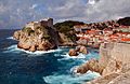
Medieval fortresses Lovrijenac & Bokar, in Dubrovnik
-
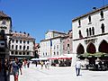
The Pjaca city square in Split
-
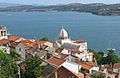
Panoramic view of Šibenik
-
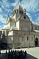
Šibenik's Cathedral
-
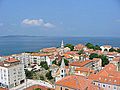
Panoramic view of Zadar
-
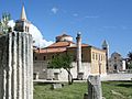
The ancient Roman forum in Zadar
-
Summer on a Krapanj street
-
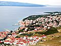
Panoramic view of Bol
-
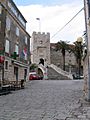
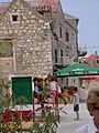
Amid the streets of Korčula
-
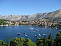
Panoramic view of Cavtat
-
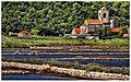
Old church in Ston
-
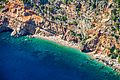
Hidden beach in southern Dalmatia
-
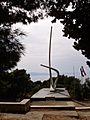
The Seagull Wings monument in Podgora, dedicated to the fallen sailors of the Yugoslav Partisan Navy

.JPG)

.jpg)


.jpg)

See also
 In Spanish: Dalmacia para niños
