Hvar facts for kids
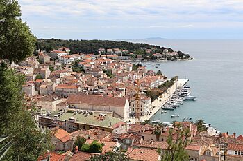
A view of the town of Hvar from the fortress
|
|
| Geography | |
|---|---|
| Location | Adriatic Sea |
| Coordinates | 43°09′N 16°45′E / 43.150°N 16.750°E |
| Area | 297.37 km2 (114.82 sq mi) |
| Length | 68 km (42.3 mi) |
| Coastline | 270 km (168 mi) |
| Highest elevation | 629 m (2,064 ft) |
| Highest point | Sv. Nikola |
| Administration | |
|
Croatia
|
|
| County | Split-Dalmatia |
| Largest settlement | Hvar (pop. 3,527) |
| Demographics | |
| Population | 10,678 |
| Pop. density | 36.1 /km2 (93.5 /sq mi) |
| Ethnic groups | Croats |
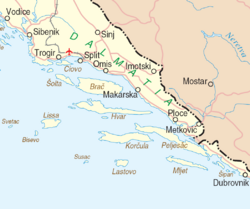
Hvar is a beautiful Croatian island in the Adriatic Sea. It's located off the Dalmatian coast, near other islands like Brač, Vis, and Korčula. Hvar is about 68 kilometres (42.25 mi) long. It has a high ridge of limestone and dolomite rocks.
What makes Hvar special is its large, fertile coastal plain and fresh water springs. Its hills are covered with green pine forests. In the farming areas, you'll find vineyards, olive groves, fruit orchards, and fields of lavender. The weather is usually mild in winter and warm in summer, with lots of sunshine. In 2021, about 10,678 people lived on Hvar. This makes it the 4th most populated island in Croatia.
Contents
Discovering Hvar's Past
Hvar's location has always been important. It sits right in the middle of Adriatic Sea sailing routes. This made it a key spot for controlling trade with Italy and the wider Mediterranean region.
Early Inhabitants and Greek Settlers
People have lived on Hvar since ancient times. The first known group was a Neolithic people. Their unique pottery style is called the Hvar culture. Later, the Illyrians lived here. Around 384 BC, the ancient Greeks started a colony called Pharos. This was built where Stari Grad is today. It's one of the oldest towns in Europe. The Greeks also planned out the farm fields of the Stari Grad Plain. This area is now a UNESCO World Heritage Site.
Medieval Times and Venetian Rule
In the medieval period, the town of Hvar became very important. It was a major naval base for the Venetian Empire. Being prosperous brought culture and arts to the island. One of Europe's first public theaters was built here. There were also fancy palaces for nobles and many beautiful public buildings.
Challenges and Changes in the 16th Century
The 1500s were a tough time for Hvar. There was the Hvar Rebellion, where locals fought against Venetian rule. Pirates and the Ottoman army also attacked the coast from the mainland. To protect themselves, people built unusual forts along the northern shore.
Austrian Rule and Economic Shifts
After a short time under Napoleonic rule, Hvar became part of the Austrian Empire. This was a more peaceful and wealthy period. Harbors were made bigger, and docks were built. Fishing and boat building grew. The island also exported more wine. Lavender and rosemary were grown for French perfumes.
However, this good time didn't last into the 20th century. Wooden sailing boats became old-fashioned. A disease called phylloxera damaged the grapevines, hurting wine production. Many islanders left to find new lives elsewhere.
The Rise of Tourism
One industry that kept growing was tourism. Today, it's a huge part of Hvar's economy. In 1868, the Hygienic Association of Hvar was formed to help visitors. This group helped build hotels, apartments, restaurants, and marinas. They also supported museums, galleries, and cafés. Now, Hvar is a top tourist spot. Conde Nast Traveler magazine often lists it as one of the best islands.
Hvar's Geography
Hvar is in the Adriatic Sea, off the Dalmatian coast of Croatia. To the north, the island of Brač is across the Hvar Channel. To the west is Vis, and to the south is Korčula. The eastern end of Hvar is only about 6 kilometres (3.7 mi) from the mainland. Along Hvar's southern coast, there are smaller islands. These include the Paklinski islands and Šćedro island.
Island Landscape
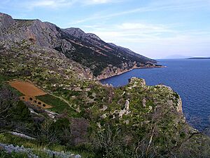
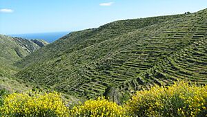
Hvar is a high ridge of limestone and dolomite rocks. It was connected to the mainland about 11,000 years ago. Then, sea levels rose and filled the valleys, creating the channels between the islands. Hvar has a typical karst landscape. This means that even with enough rain, surface water is limited. Water quickly disappears into cracks in the ground.
Farming here needs careful water saving and soil protection. Water cisterns in the fields and dry-stone walls, especially terraces on slopes, are very important for farming to succeed.
The island has typical Mediterranean vegetation. Higher, steeper areas have woody scrub. Lower slopes have pine forests with holm oak, Aleppo pines, and black pines. The small island of Šćedro is especially rich in different Mediterranean trees and plants.
Hvar island is 68 kilometres (42 mi) long. At its widest point, it is only 10.5 kilometres (6.5 mi) across. It covers an area of 297 square kilometres (115 sq mi). This makes it the 4th largest island in the Adriatic Sea. Its coastline is 254.2 kilometres (158.0 mi) long. The highest point is Sv. Nikola, which is 628 metres (2,060 ft) tall.
Towns and Villages
Hvar is part of the Split-Dalmatia County in Dalmatia, Croatia. The island has two main towns and two municipalities. Here are the main places and their populations from 2021:
- Hvar is the largest town on the island (population 3,979). For many years, it was a major naval base for the Venetian Empire.
- Jelsa is a municipality in the central part of the island (population 3,501).
- Stari Grad (population 2,772) is on the north side of the island. It's one of the oldest settlements in the Adriatic. Today, it's the main port for car ferries from Split.
- Sućuraj is a municipality on the eastern end of the island (population 426). It's closest to the mainland. A car ferry connects the island here with the port of Drvenik.
Hvar's Climate
| Weather chart for Hvar (Town of Hvar) | |||||||||||||||||||||||||||||||||||||||||||||||
|---|---|---|---|---|---|---|---|---|---|---|---|---|---|---|---|---|---|---|---|---|---|---|---|---|---|---|---|---|---|---|---|---|---|---|---|---|---|---|---|---|---|---|---|---|---|---|---|
| J | F | M | A | M | J | J | A | S | O | N | D | ||||||||||||||||||||||||||||||||||||
|
68
13
6
|
56
13
6
|
63
15
8
|
54
18
11
|
47
22
15
|
34
26
18
|
26
30
21
|
45
30
21
|
64
26
18
|
79
22
14
|
94
17
10
|
83
14
7
|
||||||||||||||||||||||||||||||||||||
| temperatures in °C precipitation totals in mm source: [1] |
|||||||||||||||||||||||||||||||||||||||||||||||
|
Imperial conversion
|
|||||||||||||||||||||||||||||||||||||||||||||||
| Weather chart for Hvar (Stari Grad) | |||||||||||||||||||||||||||||||||||||||||||||||
|---|---|---|---|---|---|---|---|---|---|---|---|---|---|---|---|---|---|---|---|---|---|---|---|---|---|---|---|---|---|---|---|---|---|---|---|---|---|---|---|---|---|---|---|---|---|---|---|
| J | F | M | A | M | J | J | A | S | O | N | D | ||||||||||||||||||||||||||||||||||||
|
69
14
7
|
59
14
8
|
66
17
10
|
57
20
13
|
46
24
17
|
38
29
21
|
26
32
23
|
46
32
23
|
62
27
19
|
81
23
16
|
94
19
13
|
96
15
9
|
||||||||||||||||||||||||||||||||||||
| temperatures in °C precipitation totals in mm source: [NOAA, from Google] |
|||||||||||||||||||||||||||||||||||||||||||||||
|
Imperial conversion
|
|||||||||||||||||||||||||||||||||||||||||||||||
Hvar has a hot-summer Mediterranean climate. This means it has mild winters and hot summers. The average yearly temperature is 16 °C (61 °F). About 703 mm (27.7 in) of rain falls each year. The island gets about 2800 hours of sunshine every year. That's about 7.7 hours of sunshine per day! Sea temperatures are lowest in February, around 14 °C (57 °F). In summer, they are warmest, usually between 23 °C (73 °F) and 27 °C (81 °F).
| Climate data for Hvar (1971–2000, extremes 1858–2014) | |||||||||||||
|---|---|---|---|---|---|---|---|---|---|---|---|---|---|
| Month | Jan | Feb | Mar | Apr | May | Jun | Jul | Aug | Sep | Oct | Nov | Dec | Year |
| Record high °C (°F) | 19.6 (67.3) |
23.4 (74.1) |
24.0 (75.2) |
27.8 (82.0) |
33.0 (91.4) |
37.0 (98.6) |
37.5 (99.5) |
37.7 (99.9) |
34.4 (93.9) |
31.5 (88.7) |
25.7 (78.3) |
20.6 (69.1) |
37.7 (99.9) |
| Mean daily maximum °C (°F) | 12.6 (54.7) |
13.0 (55.4) |
14.9 (58.8) |
17.7 (63.9) |
22.3 (72.1) |
26.4 (79.5) |
29.5 (85.1) |
29.5 (85.1) |
26.0 (78.8) |
21.8 (71.2) |
16.8 (62.2) |
13.7 (56.7) |
20.3 (68.5) |
| Daily mean °C (°F) | 9.1 (48.4) |
9.2 (48.6) |
11.1 (52.0) |
14.0 (57.2) |
18.5 (65.3) |
22.3 (72.1) |
25.0 (77.0) |
24.8 (76.6) |
21.5 (70.7) |
17.7 (63.9) |
13.3 (55.9) |
10.3 (50.5) |
16.4 (61.5) |
| Mean daily minimum °C (°F) | 5.9 (42.6) |
5.9 (42.6) |
7.7 (45.9) |
10.5 (50.9) |
14.7 (58.5) |
18.3 (64.9) |
20.9 (69.6) |
20.8 (69.4) |
17.7 (63.9) |
14.3 (57.7) |
10.1 (50.2) |
7.2 (45.0) |
12.8 (55.0) |
| Record low °C (°F) | −7 (19) |
−5.5 (22.1) |
−4.6 (23.7) |
0.0 (32.0) |
5.1 (41.2) |
10.0 (50.0) |
12.8 (55.0) |
9.7 (49.5) |
8.0 (46.4) |
4.9 (40.8) |
−3 (27) |
−5 (23) |
−5 (23) |
| Average precipitation mm (inches) | 68.4 (2.69) |
55.7 (2.19) |
62.7 (2.47) |
54.1 (2.13) |
46.7 (1.84) |
34.4 (1.35) |
26.4 (1.04) |
45.2 (1.78) |
63.7 (2.51) |
79.3 (3.12) |
94.0 (3.70) |
83.2 (3.28) |
713.7 (28.10) |
| Average precipitation days (≥ 0.1 mm) | 9.8 | 9.0 | 9.4 | 10.2 | 7.8 | 6.8 | 4.0 | 4.7 | 7.0 | 9.3 | 11.3 | 10.4 | 99.8 |
| Average snowy days (≥ 1.0 cm) | 0.1 | 0.0 | 0.0 | 0.0 | 0.0 | 0.0 | 0.0 | 0.0 | 0.0 | 0.0 | 0.0 | 0.0 | 0.1 |
| Average relative humidity (%) | 68.7 | 65.0 | 66.4 | 65.5 | 66.6 | 63.7 | 58.8 | 61.0 | 65.4 | 67.8 | 68.5 | 69.0 | 65.5 |
| Mean monthly sunshine hours | 133.3 | 155.4 | 195.3 | 222.0 | 288.3 | 324.0 | 365.8 | 334.8 | 258.0 | 198.4 | 135.0 | 124.0 | 2,734.3 |
| Percent possible sunshine | 47 | 55 | 56 | 59 | 68 | 76 | 84 | 81 | 71 | 61 | 49 | 46 | 65 |
| Source: Croatian Meteorological and Hydrological Service | |||||||||||||
Hvar's Economy
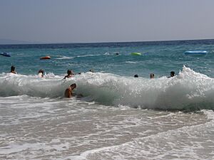
Most people on Hvar work in fishing and tourism. Hvar's mild Mediterranean climate, many beaches, and beautiful plants make it a very popular place for tourists in Europe. The island even calls itself "the sunniest spot in Europe." It gets over 2715 hours of sunlight each year!
Hvar town is the main tourist hub. It has a large public square called St Stephen's Square that opens up to the sea. During tourist season, the port is full of big yachts and sailboats. There are also all-night discos that attract many young visitors.
Another important activity is growing lavender. This plant is used to make aromatic oils and soaps. Because of this, Hvar is often called the "island of lavender."
Hvar is also one of the most famous places for winemaking in Croatia. Vineyards on the southern side of the island are known for red wines. These are made from the Plavac Mali grape. The central plain between Stari Grad and Jelsa is famous for its white wines.
The Name of Hvar
When the ancient Greeks first settled here, they called the island Paros. This was because some of them came from the island of Paros in Aegean. Later, it was called Pharos, which means "lighthouse." However, it's not clear if the name really came from the word for lighthouse. It might have been an Illyrian word "Fara," which means "seed" in modern Albanian.
Around the 3rd century BC, a Greek poet named Apollonius of Rhodes called it Piteyeia. This name came from the Greek word pitys, meaning pine tree.
From the 600s onwards, Slavic tribes like the Croats settled on the island. Because Slavic languages didn't have the /f/ sound, the official name became Quarra. Later, the name changed again to Hvar.
Since the late 1000s, the Italian name for the island has been Lesina. In the Venetian dialect, it was Liesena. These names likely came from a very old Slavic word les-, meaning "wood" or "forest." Liesena was the official name when Venice ruled Dalmatia in the 1500s and 1600s.
See also
- Hvar Observatory
- List of ancient cities in Illyria
 | Sharif Bey |
 | Hale Woodruff |
 | Richmond Barthé |
 | Purvis Young |


