
Counties of Croatia facts for kids
Quick facts for kids Counties of CroatiaHrvatske županije (Croatian) |
|
|---|---|
|
Error: No valid link was found at the end of line 15. |
|
| Category | Unitary state |
| Location | Republic of Croatia |
| Number | 20 counties + Zagreb city |
| Populations | 50,927 (Lika-Senj) – 790,017 (Zagreb) |
| Areas | 640 km2 (247 sq mi) (Zagreb) – 5,350 km2 (2,067 sq mi) (Lika-Senj) |
| Government | County government, National government |
| Subdivisions | Municipality and City |
The counties of Croatia (Croatian: županije) are like big regions or areas that Croatia is divided into. Croatia has 20 counties, plus its capital city, Zagreb. Zagreb is special because it's both a county and a city! It's different from Zagreb County, which is a separate area around the city. These counties are further split into smaller parts called cities and municipalities.
Contents
What are Counties?
Counties are the main way Croatia organizes its land and people. Think of them as states or provinces in other countries. They help manage local services and make sure everything runs smoothly across the country.
How are Counties Governed?
Each county has its own government, led by a group called the county assembly (Croatian: županijska skupština). The people in the county assembly are chosen by voters. They serve for four years, making decisions for their county.
List of Croatian Counties
Here is a list of the counties in Croatia, along with their main cities, sizes, and how many people live there.
| County | Seat (Capital City) | Area | Population (2011) | Arms | Location |
|---|---|---|---|---|---|
| Bjelovar-Bilogora | Bjelovar | 2,640 km2 (1,020 sq mi) | 119,764 | 45°54′10″N 16°50′51″E / 45.90278°N 16.84750°E | |
| Brod-Posavina | Slavonski Brod | 2,030 km2 (780 sq mi) | 158,575 | 45°09′27″N 18°01′13″E / 45.15750°N 18.02028°E | |
| Dubrovnik-Neretva | Dubrovnik | 1,781 km2 (688 sq mi) | 122,568 | 42°39′13″N 18°05′41″E / 42.65361°N 18.09472°E | |
| Istria | Pazin | 2,813 km2 (1,086 sq mi) | 208,055 | 45°14′21″N 13°56′19″E / 45.23917°N 13.93861°E | |
| Karlovac | Karlovac | 3,626 km2 (1,400 sq mi) | 128,899 | 45°29′35″N 15°33′21″E / 45.49306°N 15.55583°E | |
| Koprivnica-Križevci | Koprivnica | 1,748 km2 (675 sq mi) | 115,584 | 46°10′12″N 16°54′33″E / 46.17000°N 16.90917°E | |
| Krapina-Zagorje | Krapina | 1,229 km2 (475 sq mi) | 132,892 | 46°7′30″N 15°48′25″E / 46.12500°N 15.80694°E | |
| Lika-Senj | Gospić | 5,353 km2 (2,067 sq mi) | 50,927 | 44°42′25″N 15°10′27″E / 44.70694°N 15.17417°E | |
| Međimurje | Čakovec | 729 km2 (281 sq mi) | 113,804 | 46°27′58″N 16°24′50″E / 46.46611°N 16.41389°E | |
| Osijek-Baranja | Osijek | 4,155 km2 (1,604 sq mi) | 305,032 | 45°38′13″N 18°37′5″E / 45.63694°N 18.61806°E | |
| Požega-Slavonia | Požega | 1,823 km2 (704 sq mi) | 78,034 | 45°18′40″N 17°44′24″E / 45.31111°N 17.74000°E | |
| Primorje-Gorski Kotar | Rijeka | 3,588 km2 (1,385 sq mi) | 296,195 | 45°27′14″N 14°35′38″E / 45.45389°N 14.59389°E | |
| Šibenik-Knin | Šibenik | 2,984 km2 (1,152 sq mi) | 109,375 | 43°55′44″N 16°3′43″E / 43.92889°N 16.06194°E | |
| Sisak-Moslavina | Sisak | 4,468 km2 (1,725 sq mi) | 172,439 | 45°13′15″N 16°15′5″E / 45.22083°N 16.25139°E | |
| Split-Dalmatia | Split | 4,540 km2 (1,750 sq mi) | 454,798 | 43°10′0″N 16°30′0″E / 43.16667°N 16.50000°E | |
| Varaždin | Varaždin | 1,262 km2 (487 sq mi) | 175,951 | 46°19′16″N 16°13′52″E / 46.32111°N 16.23111°E | |
| Virovitica-Podravina | Virovitica | 2,024 km2 (781 sq mi) | 84,836 | 45°52′23″N 17°30′18″E / 45.87306°N 17.50500°E | |
| Vukovar-Srijem | Vukovar | 2,454 km2 (947 sq mi) | 179,521 | 45°13′43″N 18°55′0″E / 45.22861°N 18.91667°E | |
| Zadar | Zadar | 3,646 km2 (1,408 sq mi) | 170,017 | 44°1′5″N 15°53′42″E / 44.01806°N 15.89500°E | |
| Zagreb County | Zagreb | 3,060 km2 (1,180 sq mi) | 317,606 | 45°44′56″N 15°34′16″E / 45.74889°N 15.57111°E | |
| City of Zagreb | Zagreb | 641 km2 (247 sq mi) | 790,017 | 45°49′0″N 15°59′0″E / 45.81667°N 15.98333°E |
Images for kids
-
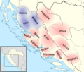
Approximate positions of the first counties of 10th century Croatia, overlaid on a map of modern Croatia and Bosnia-Herzegovina

See also
 In Spanish: Condados de Croacia para niños
