
Governorate of Dalmatia facts for kids

The Governorship of Dalmatia (called Governatorato di Dalmazia in Italian) was a special area that became part of the Kingdom of Italy. This happened in April 1941, during WWII. Italian General Vittorio Ambrosio took control of the Dalmatia region in Yugoslavia. The Governorship lasted until September 1943.
Contents
What Was the Governorship of Dalmatia?
The Governorship of Dalmatia included parts of the coast of Yugoslavia. Italy took over these areas from April 1941 to September 1943. Italy already owned a small part of the Dalmatian coast since 1919. This was the Italian Province of Zara, with Zara as its main city. It also included the island of Lagosta (now called Lastovo).
Italian leaders had long wanted to control Dalmatia. This idea was called "Italian Irredentism." However, Italy did not take all of Dalmatia. Some parts went to the Independent State of Croatia, which was a state controlled by Germany. Even so, the Italian army still had power over all of Dalmatia.
Italy divided the Governorship into three Italian provinces:
- Zara (Zadar)
- Spalato (Split)
- Cattaro (Kotor)
Italy did not officially create a new Italian region called "Dalmatia" at that time. Also, the northern Dalmatian islands of Krk (Veglia) and Rab (Arbe) were not part of the Governorship. Instead, they were added to the Italian province of Fiume.
In September 1941, Benito Mussolini, Italy's leader, ordered his army to take over more of the Dalmatian coast and islands. These included places like Ragusa, Lissa, and Pago. These areas belonged to the Croatian leader Ante Pavelić. Mussolini wanted to add them to the Governorship of Dalmatia. But Pavelić strongly disagreed, so he kept control of those areas for a while.
Areas and Population

The Governorship of Dalmatia had three main provinces:
The main city and administrative center was Zara. After autumn 1941, the Dalmatian islands of Pago and Lesina were also added. The Italian army took control of these islands. They also occupied an area of Croatia that stretched from the coast near Segna into central Bosnia. This area was close to Sarajevo and Banja Luka.
Here is a table showing the size and population of each province:
| Italian Province | Area (square kilometers) | Population |
|---|---|---|
| Provincia di Zara | 3,179 | 211,900 |
| Provincia di Spalato | 1,075 | 128,400 |
| Provincia di Cattaro | 547 | 39,800 |
| Total | 4,801 | 380,100 |
End of the Governorship
In 1943, the Kingdom of Italy changed sides in WWII and joined the Allies. After this, German forces took control of the Dalmatian area. The Governorship of Dalmatia was completely ended. It was not given to the Italian Social Republic, which was a state controlled by Nazi Germany. Instead, the area was added to the Independent State of Croatia.
However, the city of Zara remained under Italian control, even with German army presence, until 1945. The city was badly bombed in 1944.
Related pages
Images for kids
-
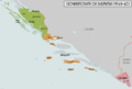
Detailed map of the three Italian provinces of the Governorate of Dalmatia: province of Zara, province of Spalato and province of Cattaro

See also
 In Spanish: Gobernación de Dalmacia para niños
