Matakohe facts for kids
Quick facts for kids
Matakohe
|
|
|---|---|

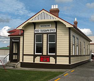
Post and telegraph office, now a museum
|
|
| Country | New Zealand |
| Region | Northland Region |
| District | Kaipara District |
| Ward | Otamatea Ward |
| Electorates |
|
| Area | |
| • Total | 14.92 km2 (5.76 sq mi) |
| Population
(2023 Census)
|
|
| • Total | 156 |
| • Density | 10.46/km2 (27.08/sq mi) |
Matakohe is a small community located in the Northland area of New Zealand. It sits near the Arapaoa River, which flows into the large Kaipara Harbour. State Highway 12 runs right through Matakohe, connecting it to nearby towns like Ruawai and Paparoa.
One of the most famous places in Matakohe is the Kauri Museum. This museum tells the story of the area's past, especially its connection to the huge kauri trees and the timber industry.
Contents
History of Matakohe
Early European Settlement
The first European settlers arrived in Matakohe in 1863. They were part of a religious group called the Albertland settlers. They cleared the land to grow crops and grass. To help the community grow, a weekly ferry service started, bringing mail and supplies. A road was also built to Paparoa.
In 1881, a very long wharf, about 1450 feet (442 metres) long, was built in Matakohe. This allowed large steamships to dock and transport goods and people.
Kauri Gum and Timber Industries
The kauri gum industry became important in Matakohe around 1867. This was one of the first places in the Kaipara District where settlers started collecting kauri gum, which was used for things like varnish.
A mill for processing flax was built in 1870, but it wasn't very successful. It was soon changed into a timber mill. Later, in the 1880s, a bigger timber mill was built. Sadly, this mill was destroyed by fire in 1906.
By the 1890s, Matakohe was growing, and its population increased. It was seen as an important town in the area. By 1902, Matakohe had places like boarding houses, a library, and shops, along with its church and school.
Changes in the 20th Century
In the early 1900s, Matakohe's main focus shifted from collecting kauri gum to dairy farming. Farmers started raising cows for milk and dairy products. Apple growing was also tried, but it didn't last long, partly because of the Great Depression in the 1930s.
Roads in the area also got much better. By 1920, many roads were covered with metal, using local limestone. This made travel easier, connecting Matakohe to other towns like Dargaville.
Marae in Matakohe
Matakohe is home to two marae, which are traditional meeting places for Māori people.
- Te Kōwhai Marae is connected to the Ngāti Whātua and Te Uri o Hau iwi (tribes).
- Matatina Marae and its meeting house, Tuohu, are traditional places for the Te Roroa iwi.
Matakohe Community and Education
Population Overview
Matakohe is a small community. In the 2023 New Zealand census, 156 people lived there. The population has grown a bit over the years. Most people living in Matakohe are of European descent, but there is also a Māori population.
Matakohe School
Matakohe School is a primary school for students from Year 1 to Year 8 (ages 5-13). It has about 49 students. The school has a long history, celebrating its 125th reunion in 2003. Over the years, it has joined with several smaller local schools. The first Matakohe School was set up in 1870.
Notable People from Matakohe
- Gordon Coates: He was born near Matakohe and went to Matakohe School. He later became the Prime Minister of New Zealand from 1925 to 1928.
 | Madam C. J. Walker |
 | Janet Emerson Bashen |
 | Annie Turnbo Malone |
 | Maggie L. Walker |


