Port Albert, New Zealand facts for kids
Quick facts for kids
Port Albert
|
|
|---|---|

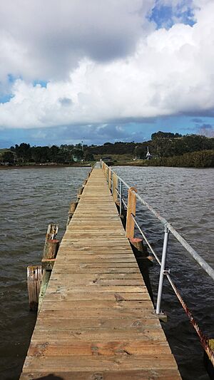
Port Albert jetty
|
|
| Nickname(s):
Albertland
|
|
| Country | New Zealand |
| Region | Auckland Region |
| Ward | Rodney ward |
| Community board | Rodney Local Board |
| Subdivision | Wellsford subdivision |
| Electorates |
|
| Area | |
| • Total | 2.61 km2 (1.01 sq mi) |
| Population
(June 2023)
|
|
| • Total | 130 |
| • Density | 49.8/km2 (129/sq mi) |
Port Albert is a small town located on the edge of the Kaipara Harbour in New Zealand. It's about 8 kilometers west of Wellsford, in the Auckland Region. This area was once called Albertland. It was one of the very last big settlements in New Zealand where British people came to live in an organized way. The soil here is very good for farming because it drains water well.
Contents
History of Port Albert: How It Began
Port Albert was originally named Albertland. It was named after Prince Albert Victor, Duke of Clarence and Avondale. The idea for this settlement came from William Rawson Brame in 1861. He was a minister from Birmingham, England.
The Albertland Settlers Arrive
William Brame started the Albertland Special Settlement Association. This group helped people who were not part of the main Church of England to move to New Zealand. These settlers were called "non-conformists." They included many different types of workers. There were farmers, carpenters, butchers, and many other skilled people.
The first Albertland settlers left England on May 29, 1862. They sailed on ships like the Matilda Wattenbach, Hanover, and William Miles. The Matilda Wattenbach was the first to arrive in Auckland on September 8, 1862. From Auckland, the new settlers traveled to the area that would become Albertland.
Finding the Perfect Place to Settle
Before the settlers arrived, a group of explorers set out from Auckland on January 21, 1862. They traveled north along the coast in a whale boat. They landed at a place called Wade, which is now Silverdale.
The explorers then walked through the Waiwera Valley and traveled by boat to the Puhoi river. This area seemed good, but local Māori people had claims to the land. This would make it hard for settlers to land.
Next, they explored a very overgrown area north of Helensville. It was too dense with bush to easily turn into farmland. Finally, they heard about the Oruawharo block on the Kaipara Harbour. They decided to go there.
Choosing the Albertland Site
After exploring the Okahukura Peninsula, the group found a good spot a few kilometers up the Ōruawharo River. This area had good scrubland and bush. It also had kauri trees, which were great for building.
The settlers were part of a special plan from the Auckland Provincial Council. This plan offered land to families:
- A man and his wife could get 40 acres (about 16 hectares).
- Each child between 5 and 18 years old could get 20 acres (about 8 hectares).
- To get the land, families had to pay their own travel costs.
- They also had to stay on the land for five years, build a house, and start farming.
More ships brought immigrants to Albertland. However, it was hard to get to the settlement, and it felt very isolated. Because of these challenges, the original big plans for a town at Port Albert did not fully happen.
Port Albert Today: Population and Community
Port Albert is considered a rural settlement. It covers an area of about 2.61 square kilometers. In 2023, the population of Port Albert was 120 people. This number has stayed the same since the 2018 census.
Who Lives in Port Albert?
In 2023, there were 66 males and 54 females living in 48 homes. The average age of people in Port Albert was 50.2 years.
Most people in Port Albert identify as European (92.5%). Some people also identify as Māori (15.0%). English is spoken by most people (95.0%).
 | Isaac Myers |
 | D. Hamilton Jackson |
 | A. Philip Randolph |

