
Helensville facts for kids
Quick facts for kids
Helensville
|
|
|---|---|
 |
|
| Country | New Zealand |
| Region | Auckland |
| Ward | Rodney ward |
| Community board | Rodney Local Board |
| Subdivision | Kumeū subdivision |
| Electorates |
|
| Area | |
| • Total | 4.05 km2 (1.56 sq mi) |
| Population
(June 2023)
|
|
| • Total | 3,330 |
| • Density | 822.2/km2 (2,130/sq mi) |
| Postcode(s) |
0800
|
Helensville (which is Māori: Te Awaroa in Māori) is a town in the North Island of New Zealand. It's located about 40 kilometers northwest of Auckland. The town is very close to the southern end of the Kaipara Harbour.
State Highway 16 goes right through Helensville. This road connects it to Waimauku, which is 16 kilometers south, and Kaukapakapa, about 12 kilometers to the northeast. The town of Parakai is just 2 kilometers to the northwest. The Kaipara River flows through Helensville and then into the Kaipara Harbour further north.
The southern part of the Kaipara Harbour was settled by Tāmaki Māori people in the 1200s or 1300s. They were attracted by the rich resources from the sea and the forests. The upper part of the Kaipara River was home to Te Tōangaroa. This was a special place where canoes could be moved between the Kaipara Harbour and the Waitematā Harbour.
By the 1400s, some of the very first pā (fortified villages) in the Auckland Region were built here. In the early 1700s, the Ngāti Whātua people, who had long ties to the area, came back and settled along the Kaipara River.
Helensville started as a settlement for logging kauri trees in 1862. By the 1870s, it had grown into an important center for the southern Kaipara area. From 1911 until the 1980s, Helensville was a major hub for the dairy farming industry.
Contents
- What's in a Name? The Story of Helensville
- Helensville's Location and Landscape
- A Look Back: Helensville's History
- Helensville's Population and People
- Helensville's Economy and Jobs
- Learning in Helensville: Schools
- Getting Around: Transport in Helensville
- Famous People from Helensville
- Images for kids
What's in a Name? The Story of Helensville
The name Helensville comes from an early settler named John McLeod. He named his house "Helen's Villa" after his wife, Helen Alexander. The town that grew around his house became known as Helensville. The first time the name Helensville appeared in print was in 1863.
The Māori language name for the area is Te Awaroa. This means "The Wide River." It's the name of a smaller stream that joins the Kaipara River right at Helensville.
Helensville's Location and Landscape
_(cropped).jpg)
Helensville is located on the eastern side of the Kaipara River. It's just south of the large Kaipara Harbour. The town is situated between two smaller streams that flow into the river: the Awaroa Stream to the north and the Mangakura Stream to the south.
The town itself is built on a slightly higher area of land. The highest point nearby is a 182-meter hill called Paehoka. This hill is located to the south, where Kiwitahi Road and Old North Road meet.
Historically, this area was a wetland and a flood plain for the Kaipara River. However, by the late 1800s, the land around the Kaipara River was turned into farms. The hills to the east of Helensville were once covered in thick kauri forests.
A Look Back: Helensville's History
Māori Settlement and Early Life
Māori have lived in the Auckland Region since about the 1200s or 1300s. Old Māori stories talk about magical beings called Tūrehu who lived in the area before Māori arrived. The Kaipara Harbour is linked to the Tūrehu Tumutumuwhenua and his wife Kui. The Ngāti Whātua people, who live around the harbor today, consider them to be their ancestors.
One of the first known iwi (tribes) to settle here was Te Tini o Maruiwi. They came from Maruiwi, who was the captain of the Kahutara canoe. This was one of the first migratory canoes to arrive in New Zealand.
The Ngāti Whātua people have stories about the Māhuhu-ki-te-rangi canoe arriving at the Kaipara Harbour. Some of its crew members, like Rongomai, Mawete, and Po, settled at Tāporapora. They joined the descendants of Toi, who were already living there. Tāporapora was a very fertile sandy area that slowly washed away into the sea. Manukapua Island is a small part of what's left of it.
People were drawn to the southern Kaipara Harbour because it had so many resources. There was plenty of food from the harbor and valuable kauri trees in the surrounding forests. Archeological finds show that many of the earliest people in the area hunted moa, a large flightless bird.
The southern Kaipara was also important for travel because of Te Tōangaroa. This was a special path where canoes could be pulled between the Kaipara Harbour and the Waitematā Harbour. This was done by using the Kaipara River and the Kumeū River.
Most major settlements in the area were built on higher ground away from the Kaipara River. This was because the land right next to the river was very swampy. The Ohirangi wetlands (called Te Tareminga in Māori) were used to trap moa a long time ago.
Some traditional Māori names for the area include Tungoutungou. This name describes how the Kaipara River winds and turns near Helensville. Further upstream, near the Helensville Bridge, the area was known as Te Pu a Tangihua.
Over time, many Tāmaki Māori groups developed into the Ngā Oho tribe. Around the 1400s, a group called Ngāti Awa, who came from the Mātaatua canoe, settled on the Te Korowai-o-Te-Tonga Peninsula. They were led by Tītahi. This tribe was known for building many terraced pā (fortified villages). There are over 18 pā sites in the Helensville area. These are likely some of the oldest fortified pā in Auckland. For example, Ōtakanini pā, near Parkhurst northwest of Helensville, has been dated back to at least 1400 AD.
By the mid-1600s, Ngāti Awa and Ngā Oho were fighting over land. Hauparoa, a descendant of Tītahi, asked his relative Maki for help. Maki was a famous warrior from the Kāwhia Harbour. Maki helped Ngāti Awa take control of the region and united many Tāmaki Māori tribes, including Ngā Oho.
Later, Maki attacked Ngāti Awa after a disagreement about kūmara (sweet potatoes). Over time, Maki's descendants became known as Te Kawerau ā Maki. This name refers to the kūmara incident. Maki chose the southern Kaipara as his main base. His children then moved to different parts of the northern and western Auckland Region.
Ngāti Whātua Returns and the Musket Wars
In the 1600s and early 1700s, Ngāti Whātua tribes started to return to the southern Kaipara Harbour area from Northland. They mainly arrived on the canoes Te Potae o Wahieroa and Te Wharau. At first, the tribes were friendly, and important marriages took place between them.
However, fighting eventually broke out. Ngāti Whātua asked for help from Kāwharu, a famous Tainui warrior from Kawhia. Kāwharu repeatedly attacked settlements in the Waitākere Ranges. These attacks were known as Te Raupatu Tīhore, or "the stripping conquest."
Lasting peace between Te Kawerau ā Maki and Ngāti Whātua was finally made by Te Au o Te Whenua, Maki's grandson. He set the rohe (border) between Muriwai Beach and Rangitōpuni (Riverhead). Ngāti Whātua then divided the land among their different hapū (sub-tribes). This included Te Taoū, who became very powerful in the Kaipara River area.
Around 1740, a war started between Ngāti Whātua and Waiohua. Waiohua was a group of Tāmaki Māori tribes based on the Tāmaki isthmus (where Auckland city is today). Kiwi Tāmaki, the main chief of Waiohua, launched a surprise attack in the south Kaipara. This was in response to past problems and to help a group within Ngāti Whātua who were against Te Taoū.
Kiwi Tāmaki's group chased the survivors south to the pā at Te Mākiri (which is now Helensville). They faced Tuperiri and Waha-akiaki, two important members of Te Taoū who managed to survive. By 1741, Ngāti Whātua had successfully fought against Kiwi Tāmaki. Members of Te Taoū then settled on the Auckland isthmus.
An early fight between Te Taoū and Ngāpuhi during the Musket Wars happened at Paehoka, south of Helensville. This was probably in the late 1700s. Conflicts continued into the early 1800s. In 1818, the English missionary Samuel Marsden saw Ngāti Whātua of the Kaipara River being attacked from the north.
After the battle of Te Ika a Ranganui at Kaiwaka, Ngāti Whātua left the area. Only a small group stayed behind to maintain ahi kā (visible land occupation). Ngāti Whātua started to return to the Kaipara River from 1828. By 1835, they were fully re-established in the area.
European Settlement and Growth
.jpg)


After the Treaty of Waitangi was signed in 1840, Ngāti Whātua used coastal trading ships. They supplied goods to early European settlers in Auckland. Large parts of the southern Kaipara harbor were bought by the Crown between 1853 and 1865. Ngāti Whātua hoped this would lead to European settlements and boost the local economy.
In 1862, a settler from Nova Scotia named John McLeod built a kauri timber mill. It was on the eastern banks of the Kaipara River, where Helensville is today. McLeod named his house "Helen's Villa" after his wife. This name then became the name for the town that grew up around the timber mill. McLeod cut down kauri trees on the land near his mill. A few years later, Ngāti Whātua set up a kāinga (village) on the opposite side of the river.
The town grew thanks to the kauri timber industry and the collection of kauri gum. In 1865, the road from Riverhead to Helensville was made better. Farms were also developed in the 1870s. By 1870, Helensville had become the main trading and transport center for the settlements further north in the Kaipara Harbour.
From 1875 to 1881, a short railway line operated between Kumeū, south of Helensville, and Riverhead. Riverhead was on the upper part of the Waitematā Harbour. This railway brought more business to Helensville, which grew into a proper town and an economic hub. In 1881, the North Auckland Line railway was extended to Helensville, and the Helensville railway station opened.
In 1879, St Matthew's Anglican Church was built in Helensville. This was the first church in the wider southern Kaipara area. It served nearby rural communities like Kumeū and Waimauku. In 1882, the first bridge across the Kaipara River was built at Te Horo Point. The goal was to open up more farmland to the west.
Between 1865 and 1900, the Native Land Court changed how Ngāti Whātua lands were owned. Land that was once owned by the community was divided up among individuals. This slow process led to much of the land being taken from Māori. By 1900, almost all of the southern Kaipara area was no longer owned by Ngāti Whātua. They had kept only about 10% of their traditional rohe (territory).
Dairy Farming and Tourism
The kauri logging and gum industries started to decline by 1900 and were gone by 1920. The Helensville Show, an annual agricultural show, began in 1900. It became a big event in Helensville, attracting people from all the surrounding areas.
In 1911, the Kaipara Dairy Company was started in Helensville. It became the town's largest employer. Helensville thrived thanks to the dairy industry and sheep farms. Also, tourists started coming to Helensville in the early 1900s because of the Parakai thermal springs, which have hot water.
In 1927, St Matthew's Anglican Church was rebuilt because a new, larger church was needed. In the 1930s, a forest of non-native pine trees called the Woodhill Forest was planted on the Te Korowai-o-Te-Tonga Peninsula. This became an important industry for the area. During World War II, the 15th Battalion of the Home Guard was based in Helensville.
The dairy factory closed in the late 1980s because farming in the area became less profitable. The sand extraction industry then became a major employer in the town. This happened after Mt Rex and Winstone built processing facilities near Helensville in the 1990s.
In 2009, the Helensville railway station stopped offering passenger train services.
Helensville's Population and People
Helensville is considered a small urban area. It covers about 4.05 square kilometers. As of 2023, it has an estimated population of about 3,279 people. This means there are about 809 people per square kilometer.
The population of Helensville has been growing:
- In 2006, there were 2,532 people.
- In 2013, there were 2,673 people.
- In 2018, there were 2,820 people.
- In 2023, there were 3,279 people.
In the 2023 census, there were slightly more females than males. The average age was 36.9 years old.
- About 21.6% of the people were under 15 years old.
- About 14.4% were 65 years or older.
People in Helensville come from different backgrounds:
- Most people (84.1%) are European (also called Pākehā).
- About 21.0% are Māori.
- Smaller groups include Pasifika (7.7%) and Asian (5.7%).
English is spoken by most people (96.4%). The Māori language is spoken by 3.5% of the population.
When it comes to religion:
- 25.7% of people identify as Christian.
- 61.6% said they had no religion.
Many people in Helensville have completed higher education. About 14.8% have a bachelor's degree or higher. The average income was $42,800. Most people (53.4%) work full-time.
Helensville's Economy and Jobs
Helensville used to be known for its forestry and dairy industries. Now, it's becoming more of a "dormitory suburb" for Auckland. This means more people live in Helensville but work in Auckland. There are also more "lifestyle blocks" (smaller farms or large properties) in the area.
The town also benefits from the wine-making region around Kumeū, which is 20 kilometers south. The main tourist attraction is the hot springs at nearby Parakai.
Helensville has its own local newspaper, the Helensville News, which comes out every month. The town is part of the North West Country Inc business improvement district. This group helps businesses from Kaukapakapa to Riverhead.
Learning in Helensville: Schools
Helensville has several schools for students of different ages.
Kaipara College: High School Education
Kaipara College is the local high school for students in years 9 to 13 (ages 13-18). It has about 1,000 students. The school first opened in 1924 as Helensville District High School. It changed its name to Kaipara College in 1959.
Helensville Primary School: For Younger Students
Helensville Primary School is for younger students, from years 1 to 8 (ages 5-13). It has about 400 students. This school was founded in 1877.
Tau Te Arohanoa Akoranga: Christian-Based Learning
Tau Te Arohanoa Akoranga is a special campus of Kingsway School. It offers a Christian-based education.
All these schools welcome both boys and girls.
Getting Around: Transport in Helensville
The Helensville railway station is on the North Auckland Line. However, passenger train services stopped in 2009.
Now, the only public transport between Helensville and central Auckland is by bus. You can take a bus to Westgate in West Auckland. From there, you transfer to another bus (route 110) to get to central Auckland. During busy times (rush hours), there's an express bus that goes directly to Downtown Auckland.
Famous People from Helensville
- Jim Sheddan (1918–2010), a Royal New Zealand Air Force flying ace during World War II.
Images for kids
-
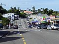
Helensville's Commercial Road.
