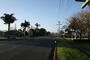
Parakai facts for kids
Parakai is a town in the North Island of New Zealand. It's about 43 kilometers (27 miles) northwest of Auckland. The town is very close to the southern end of the Kaipara Harbour.
Nearby towns include Helensville, about 3 km (1.9 miles) to the south-east. Waioneke is 22 km (14 miles) to the north-west. The area around Parakai is mostly used for farming. Farmers here raise dairy cows, sheep, and deer.
Just 2 km (1.2 miles) north of Parakai is West Auckland Airport. This is a small airfield used for general aviation. It's also a popular spot for parachuting, where people jump out of planes with parachutes.
Contents
Discovering Parakai's Past
Māori History and Traditional Names
The Auckland Region has been home to Māori for a very long time. They settled here around the 13th or 14th centuries. The traditional Māori name for this area was Kaipātiki. This name described the swampy, flat land where flounder fish could be caught. Parakai is located within the rohe, or tribal area, of Ngāti Whatua o Kaipara.
How Parakai Got Its Name
In the early 1900s, this settlement was known as the Helensville Hot Springs. A hot spring resort was built here, making it a popular place for tourists. When a post office was being set up, a new name was needed. This was to avoid confusion with Helensville, which was to the south.
Residents liked the name Kaipara, but there was already a place called Kaipara Flats. So, a different name was chosen: Parakai. This name is actually "Kaipara" spelled backward! Newspapers first mentioned Parakai in 1908. For a short time, the area was even called Babylon Flats before it became Parakai.
In the early 1900s, a small factory called Ambury and English's Creamery operated in Parakai. It processed milk and was located at the corner of Fordyce Road and the main road to South Head. The Parakai Rugby Club played here from 1918 to 1937. Later, in 1943, it joined with the Helensville Rugby Club.
Haranui Marae: A Special Meeting Place
Haranui Marae, also known as Otakanini Marae, is about 6 km (3.7 miles) north of Parakai. A marae is a traditional meeting ground for Māori people. This marae is important to the Ngāti Whātua o Kaipara and Ngāti Whātua hapū (sub-tribes) of Ngāti Whātua Tūturu and Te Taoū. It features a special meeting house called Ngā Tai i Turia ki te Maro Whara.
Parakai's Population and Community
Statistics New Zealand describes Parakai as a small urban area. It covers about 1.45 square kilometers (0.56 square miles). In the 2023 New Zealand census, Parakai had a population of 1,083 people. This was a small decrease from the 2018 census.
The median age in Parakai was 36.8 years. About 21.1% of the people were under 15 years old. The community is diverse, with people identifying with different ethnic groups. These include European (Pākehā), Māori, Pasifika, and Asian. Most people speak English, but some also speak Māori language and other languages.
Local Government and Representation
Parakai is part of the Rodney Ward of the Auckland Council. It is also part of the Kumeu Subdivision of the Rodney Local Board. For national elections, Parakai is in the Kaipara ki Mahurangi general electorate. It is also part of the Te Tai Tokerau Māori electorate, which is a special voting area for Māori.
Learning in Parakai
Parakai School is a school for students in years 1 to 8 (ages 5 to 13). It is a co-educational school, meaning both boys and girls attend. The school serves students from the areas around the Kaipara River and up the South Kaipara Heads Peninsula.
Exploring Parakai's Hot Springs
Parakai is famous for its hot springs. These springs have natural geothermal mineral water. There's a complex of mineral pools and fun activities called Parakai Springs. The water for these pools comes from deep underground. It's drawn from a geothermal aquifer, which is a layer of rock that holds hot water.
History of the Hot Springs
There isn't much written history about Māori using these specific springs. However, it's thought that the local iwi, Ngāti Whātua, knew about and used the hot springs in nearby Helensville.
In 1864, Robert Mair "discovered" the hot springs. At that time, there was just one natural hot pool. In 1905, a well was dug 20 meters (66 feet) deep. A year later, a new bathhouse was built. This started a period of about 25 years where tourism and investment in the hot pools grew. At its busiest, the area had a Massage Institute, 24 private baths, and separate swimming baths for men and women.
However, during the Great Depression and World War II, fewer visitors came. By 1958, two of the boarding houses had burned down, and the swimming baths were closed.
 | Dorothy Vaughan |
 | Charles Henry Turner |
 | Hildrus Poindexter |
 | Henry Cecil McBay |


