Kaukapakapa facts for kids
Quick facts for kids
Kaukapakapa
|
|
|---|---|

Kaukapakapa sign
|
|
| Country | New Zealand |
| Region | Auckland Region |
| Ward | Rodney ward |
| Community board | Rodney Local Board |
| Subdivision | Kumeū subdivision |
| Electorates |
|
| Area | |
| • Total | 5.26 km2 (2.03 sq mi) |
| Population
(June 2023)
|
|
| • Total | 1,080 |
| • Density | 205.3/km2 (531.8/sq mi) |
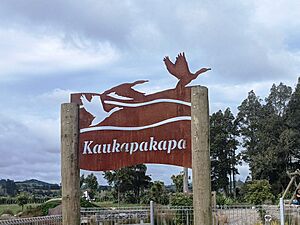
Kaukapakapa is a small town in the North Island of New Zealand. It's located in the Auckland Region, about 50 kilometers (31 miles) northwest of the city of Auckland.
State Highway 16 goes through the town. This road connects Kaukapakapa to Helensville (about 12 km southwest) and Araparera (about 14 km north). A railway line, called the North Auckland Line, also runs through the town. The Kaukapakapa River starts near the town and flows west into the Kaipara Harbour.
The name "Kaukapakapa" comes from the Māori language. It means "to swim with much splashing." Locals often call the town "Kaukap" for short.
Contents
Exploring Kaukapakapa's Location
Kaukapakapa is in the western part of Rodney. It sits at the point where boats can easily travel on the Kaukapakapa River. This river then flows into the Kaipara Harbour. The town is also close to Helensville.
A Look Back at Kaukapakapa's Past
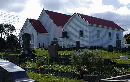
European settlers first came to this area in 1860. The government bought land from the local Māori people. A few settlers from England and Scotland arrived, and a Methodist church was built in 1872.
From 1863, a boat service ran once a month between Kaukapakapa and the northern Kaipara area. By 1881, about 311 people lived here. The town grew on both sides of the river. Roads connected Kaukapakapa to places like Riverhead, Tauhoa, and Helensville by the early 1880s. However, these roads were not very good, so most people traveled by river. Even in 1920, many roads were still unpaved.
Early Industries and Growth
The kauri timber industry was very important for the area's growth. Kauri logs were floated down the Kaukapakapa River to the Kaipara Harbour. From there, they were loaded onto ships and sent overseas.
Another important industry was kauri gum digging, which started around 1873-74 and continued until at least 1914. Processing flax was also a big industry in the 1880s. A shipyard operated in Kaukapakapa from 1864 into the 1880s.
The North Auckland railway line reached Kaukapakapa in 1889. A creamery (a place to make dairy products) was built next to the railway station. This helped the growing dairy industry. St Clement's Anglican Church was built in Kaukapakapa in 1919.
In 2008, a company called Genesis Energy wanted to build a gas power station nearby. It was called the Rodney Power Station. Even though many locals were against it, the project was approved in 2009. However, the plan was eventually stopped in 2015.
Understanding Kaukapakapa's Population
Statistics New Zealand describes Kaukapakapa as a rural settlement. It covers about 5.26 square kilometers (2.03 sq mi). In 2023, the estimated population was 1,062 people.
| Historical population for Kaukapakapa | ||
|---|---|---|
| Year | Pop. | ±% p.a. |
| 2006 | 540 | — |
| 2013 | 609 | +1.73% |
| 2018 | 876 | +7.54% |
| 2023 | 1,062 | +3.93% |
The population of Kaukapakapa was 1,062 in the 2023 New Zealand census. This was a big increase of 186 people (21.2%) since the 2018 census. The median age in Kaukapakapa was 34.7 years. This is younger than the national average of 38.1 years.
- About 24.3% of the people were under 15 years old.
- About 18.1% were aged 15 to 29.
- About 49.2% were aged 30 to 64.
- About 9.0% were aged 65 or older.
Most people in Kaukapakapa identified as European (92.1%). Other groups included Māori (8.8%), Asian (5.1%), and Pasifika (2.0%). English was spoken by 96.3% of the people.
When it came to religion, 24.6% identified as Christian. A large number, 66.1%, said they had no religion.
For those aged 15 and older, 16.4% had a university degree or higher. The average income was $54,200. This was higher than the national average of $41,500. Most people (58.6%) worked full-time.
Kaukapakapa Rural Area
The Kaukapakapa Rural area is larger, covering 90.83 square kilometers (35.07 sq mi). It surrounds the town to the west, north, and east. In 2023, its estimated population was 1,770 people.
| Historical population for Kaukapakapa Rural | ||
|---|---|---|
| Year | Pop. | ±% p.a. |
| 2006 | 1,695 | — |
| 2013 | 1,464 | −2.07% |
| 2018 | 1,704 | +3.08% |
| 2023 | 1,770 | +0.76% |
| The 2006 population is for a smaller area of 80.93 km2 called Te Kuru, which included Kaukapakapa town. | ||
In the 2023 census, the Kaukapakapa Rural area had 1,770 people. The median age was 42.7 years.
- About 20.5% of people were under 15 years old.
- About 14.9% were aged 15 to 29.
- About 50.3% were aged 30 to 64.
- About 14.2% were aged 65 or older.
Most people in the rural area were also European (93.9%). Other groups included Māori (11.2%) and Pasifika (3.6%). English was spoken by 97.8% of the people.
For religion, 27.8% identified as Christian. 62.7% said they had no religion.
Of those aged 15 and older, 16.2% had a university degree or higher. The average income was $48,700. Most people (56.1%) worked full-time.
How Kaukapakapa is Governed
Kaukapakapa used to be part of Rodney County. In 1989, it became part of the new Rodney District Council.
Today, Kaukapakapa is part of the Rodney Ward of the Auckland Council. It is also part of the Kumeu subdivision of the Rodney Local Board.
For national elections, Kaukapakapa is in the Kaipara ki Mahurangi area.
Local Businesses and Economy
The town is part of the North West Country Inc. This is a group that helps businesses in the area, from Kaukapakapa to Riverhead.
Learning in Kaukapakapa
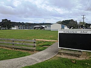
Kaukapakapa School is a primary school for students in years 1 to 8. It opened in 1873. As of 2024, it has 261 students.
There are also two places for younger children to learn:
- The Kaukapakapa Pre-School, which is near the primary school.
- A Playcentre, which started in 1976 and is on Macky Road.
Famous People from Kaukapakapa
- Alan Gibbs - a well-known businessman and art collector.
- Tony Woodcock – a former All Black rugby player (New Zealand's national rugby team).
Places to Visit and Enjoy
The Omeru Scenic Reserve is located north of Kaukapakapa. It's where the Omeru Stream and Waitangi Stream meet. This reserve was given to Auckland in 1971 by Basil Orr. It has several beautiful waterfalls, including the Omeru Falls and Waitangi Falls. You can also find the site of the Omeru pā (a Māori fortified village) within the reserve.
 | Kyle Baker |
 | Joseph Yoakum |
 | Laura Wheeler Waring |
 | Henry Ossawa Tanner |


