Kumeū facts for kids
Quick facts for kids
Kumeū
|
|
|---|---|

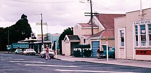
The main road of Kumeū in 1973
|
|
| Country | New Zealand |
| Region | Auckland Region |
| Ward | Rodney ward |
| Local board | Rodney Local Board |
| Subdivision | Kumeū subdivision |
| Electorates |
|
| Area | |
| • Total | 6.83 km2 (2.64 sq mi) |
| Population
(June 2023)
|
|
| • Total | 6,930 |
| • Density | 1,014.6/km2 (2,628/sq mi) |
Kumeū is a town in the Auckland Region of New Zealand. It is located about 25 kilometers north-west of the city center. Major roads and railway lines pass through Kumeū. Nearby towns include Huapai to the west and Riverhead to the north.
The area around Kumeū has been home to Tāmaki Māori people for a long time. This started as early as the 13th or 14th centuries. The land is very important to the Ngāti Whātua o Kaipara and Te Kawerau ā Maki tribes. The Kumeū River valley was a key travel route. People used a special path called Te Tōangaroa to move canoes overland. This path connected the Kaipara and Waitematā harbors.
Kumeū village started to grow in the 1870s. This happened after a railway line was built. It linked Kumeū to Riverhead. At first, the town was important for kauri logging and kauri gum trading. Later, it became a center for farming. The Kumeu Stockyards opened in 1915. Since 1921, Kumeū has hosted a big agricultural show called the Kumeu Show. By the 1940s, people from Croatia, called Croatian New Zealanders, started a successful winemaking industry here. Since the 1970s, Kumeū and Huapai have grown together. They are now often seen as one urban area called Kumeū-Huapai.
Contents
What Does Kumeū Mean?
The name Kumeū comes from the Māori language. It first referred to an area south of today's Kumeū. This name is linked to an ancestor of the Te Kawerau ā Maki tribe, Te Kauea.
The Kumeū River was first mentioned in English in the 1850s. The Kumeu Road District was named in 1861. The settlement itself, Kumeu, was first called Kumeu or Kumeu Flats in 1867.
Where is Kumeū Located?

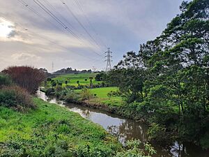
Kumeū is a town north-west of Auckland. It sits along the Kumeū River. This river is a main branch of the Kaipara River. Kumeū is east of Huapai. These two towns are part of one large urban area. Other nearby towns include Riverhead to the north-east and Waimauku to the west. Urban West Auckland suburbs are about 6 kilometers south-east of Kumeū. These include Westgate.
The Kumeū River area used to be a wetland. It was a flood plain before European settlers arrived. The Kumeū valley often flooded in the 1920s and 1930s. A very big flood happened in 1954.
What is the Climate Like in Kumeū?
| Climate data for Kumeu (1971-2000 normals, extremes 1978-1989, 2006-2011) | |||||||||||||
|---|---|---|---|---|---|---|---|---|---|---|---|---|---|
| Month | Jan | Feb | Mar | Apr | May | Jun | Jul | Aug | Sep | Oct | Nov | Dec | Year |
| Record high °C (°F) | 29 (84) |
31.3 (88.3) |
27.2 (81.0) |
26.4 (79.5) |
24 (75) |
20.5 (68.9) |
19.5 (67.1) |
20 (68) |
22 (72) |
23.7 (74.7) |
26.4 (79.5) |
28.5 (83.3) |
31.3 (88.3) |
| Mean daily maximum °C (°F) | 23.4 (74.1) |
24 (75) |
22.7 (72.9) |
20.3 (68.5) |
17.7 (63.9) |
15.5 (59.9) |
14.7 (58.5) |
15.1 (59.2) |
16.3 (61.3) |
17.9 (64.2) |
19.7 (67.5) |
21.9 (71.4) |
19.1 (66.4) |
| Daily mean °C (°F) | 18.4 (65.1) |
18.9 (66.0) |
17.6 (63.7) |
15.1 (59.2) |
12.8 (55.0) |
10.9 (51.6) |
10 (50) |
10.6 (51.1) |
12.3 (54.1) |
13.5 (56.3) |
15.1 (59.2) |
16.9 (62.4) |
14.3 (57.8) |
| Mean daily minimum °C (°F) | 13.3 (55.9) |
13.8 (56.8) |
12.8 (55.0) |
9.9 (49.8) |
7.8 (46.0) |
6.2 (43.2) |
5.3 (41.5) |
6.1 (43.0) |
8.2 (46.8) |
9 (48) |
10.5 (50.9) |
11.9 (53.4) |
9.6 (49.2) |
| Record low °C (°F) | 4.4 (39.9) |
4.4 (39.9) |
3.3 (37.9) |
0.8 (33.4) |
−2.2 (28.0) |
−4.4 (24.1) |
−5.2 (22.6) |
−2.2 (28.0) |
−1.5 (29.3) |
−0.3 (31.5) |
2.5 (36.5) |
1 (34) |
−5.2 (22.6) |
| Source: NIWA | |||||||||||||
History of Kumeū
The Kumeū area was first settled by people from the Dalmatian coast of Croatia. Many of these families had a long history of making wine.
Who Lives in Kumeū?
Statistics New Zealand describes Kumeū-Huapai as a small urban area. It covers about 6.83 square kilometers. As of 2018, it had an estimated population of 6,948 people. This means there are about 1,017 people living per square kilometer.
| Historical population for Kumeū-Huapai | ||
|---|---|---|
| Year | Pop. | ±% p.a. |
| 2006 | 1,386 | — |
| 2013 | 1,455 | +0.70% |
| 2018 | 3,480 | +19.05% |
| 2023 | 6,948 | +14.83% |
| The 2006 population is for a smaller area of 6.31 km2. | ||
In the 2023 New Zealand census, Kumeū-Huapai had 6,948 residents. This was a big increase of 99.7% since the 2018 census. There were 3,417 males and 3,513 females. The average age was 34.9 years. About 25.3% of people were under 15 years old.
People could choose more than one ethnicity. About 70.2% identified as European (Pākehā). About 9.4% were Māori. Around 24.6% were Asian. English was spoken by 93.8% of people. About 34.2% of people were born outside New Zealand.
About 26.7% of people were Christian. Many people, 55.1%, said they had no religion.
Many adults in Kumeū-Huapai have good education. About 24.6% have a university degree or higher. The average income was $61,000. Most people (63.2%) were employed full-time.
People in Rural Kumeū Areas
The rural areas around Kumeū and Huapai cover about 40.72 square kilometers. As of 2023, about 3,765 people lived there. This means about 92 people per square kilometer.
| Historical population for Kumeū rural areas | ||
|---|---|---|
| Year | Pop. | ±% p.a. |
| 2006 | 3,054 | — |
| 2013 | 3,348 | +1.32% |
| 2018 | 3,684 | +1.93% |
| 2023 | 3,765 | +0.44% |
| The 2006 population is for a larger area of 49.35 km2. | ||
In the 2023 census, the rural Kumeū areas had 3,765 people. The average age was 43.6 years. About 14.3% of people were under 15 years old.
About 81.0% of people identified as European. About 12.8% were Māori. English was spoken by 95.2% of people. About 25.3% of people were born overseas.
About 27.3% of people were Christian. Many people, 58.1%, said they had no religion.
About 16.1% of adults had a university degree or higher. The average income was $44,700. Most people (52.4%) were employed full-time.
What is Kumeū Known For?
The Kumeū area is famous for its wine. Many wineries here produce well-known Chardonnay and Sauvignon blanc wines. Winemaking is the main industry in Kumeū and nearby towns like Huapai and Waimauku.
Some famous wineries include:
- Kumeu River Wines: Started in 1944.
- Coopers Creek: Started in 1980.
- Landmark Estate: Founded in 1937.
- Matua Valley: Started in 1966, but closed in 2016.
- Nobilos: Started in 1943 by Nikola Nobilo. It is now New Zealand's second largest wine company.
- Soljans Estate Winery: Started in 1932 in Henderson. They moved to Kumeū in 2002.
Kumeū is also part of the North West Country Inc business area. This group helps businesses from Kaukapakapa to Riverhead.
Fun Things to Do in Kumeū
The area is popular for lifestyle block farming. This means people live on small farms. It is also popular for horse riding. The Kumeu Agricultural and Horticultural Society holds a very large annual show. It happens every year on the second weekend in March.
Nearby places like Woodhill forest and Muriwai Beach offer many outdoor activities.
Music and Events in Kumeū
Since 1948, Kumeū has had a brass band. They play in parades, concerts, and compete in events.
The Kumeu Showgrounds also host the annual Auckland Folk Festival. This is a four-day event with music, dancing, and workshops. It usually takes place on the last weekend in January.
How to Get Around Kumeū?
The North Auckland Line railway passes through Kumeū. From 1875 to 1881, Kumeū was the end point of a railway line. This line connected Kumeū to Riverhead, where ferries went to Auckland. In 1881, the main railway line from Auckland reached Kumeū. This made the old line to Riverhead unnecessary, so it closed.
In 2007, there were plans to extend train services to Helensville. Temporary stations were built at Huapai and Waimauku. The service started in July 2008 for a one-year trial. However, it was stopped permanently in 2009.
Schools in Kumeū
Kumeū has two primary schools for years 1–8:
- Huapai District School: Opened in 1919.
- Matua Ngaru School: Opened in 2019.
The state-integrated Hare Krishna School is for years 1–10.
Most high school students go to schools in nearby suburbs. These include Kaipara College and Massey High School.
The Kumeu Library is located in Huapai. It is part of Auckland Libraries. In 2021, the Huapai Service Centre joined the library. It now offers both library and council services.
 | Tommie Smith |
 | Simone Manuel |
 | Shani Davis |
 | Simone Biles |
 | Alice Coachman |


