
Huapai facts for kids
Quick facts for kids
Huapai
|
|
|---|---|
.jpg)
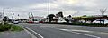
The main road in Huapai
|
|
| Country | New Zealand |
| Region | Auckland Region |
| Ward | Rodney ward |
| Local board | Rodney Local Board |
| Subdivision | Kumeū subdivision |
| Electorates |
|
Huapai is a small town located north-west of Auckland, New Zealand. It's a place where State Highway 16 and the North Auckland Railway Line both pass through. Huapai is next to Kumeū to the east, Riverhead to the north-east, and Waimauku to the west.
The wider area around Huapai has been home to Tāmaki Māori people since the 1200s or 1300s. It's a very important place for the Ngāti Whātua o Kaipara and Te Kawerau ā Maki tribes. The Kumeū River valley was a key travel route. This was because of a special path called Te Tōangaroa. Here, waka (Māori canoes) could be pulled overland between the Kaipara Harbour and Waitematā Harbour.
Huapai started to grow in the 1870s. This happened after a railway line, the Kumeu–Riverhead Section, was built. This line connected Kumeū to Riverhead along the old Te Tōangaroa path. In 1914, Huapai was set up as a rural area for homes and was promoted as a great place to grow fruit. By the 1940s, Croatian New Zealanders helped create a successful winemaking industry in Kumeū and Huapai. Since the 1970s, Kumeū and Huapai have grown together. They are now often seen as one big town called Kumeū-Huapai.
Contents
What's in a Name? The Meaning of Huapai
The name Huapai was created by two property developers, Lionel Hanlon and G.W. Green. They came up with the name in the early 1910s. It comes from Māori language words and means "Good Fruit".
Before this, the area had other names during early European settlement. Some of these were Kumeu North, Kumeu Flat, and Pukekorari. Hanlon and Green used the name Huapai for a large area of about 2,000 hectares (5,000 acres). This land was north of Kumeū. Their company, Northern Fruitlands Ltd., turned it into apple and pear orchards. The traditional Māori name for Huapai is Tūrakiawatea. This name is linked to a Te Kawerau ā Maki ancestor named Ruarangi. He likely traveled through this area in the 1500s.
Where is Huapai? Geography and Rivers

Huapai is a town located north-west of Auckland. It sits along the banks of the Kumeū River. This river is a main branch of the larger Kaipara River. Huapai is west of Kumeū. The two towns have grown so much that they now form one continuous urban area. Huapai is also close to Riverhead (to the north-east) and Waimauku (to the west). The urban areas of West Auckland are about 6 kilometers (3.7 miles) to the south-east. These include places like Westgate and the NorthWest Shopping Centre.
The Kumeū River area was naturally a wetland and flood plain before European settlers arrived. The Kumeū valley often flooded in the 1920s and 1930s. A very big flood happened there in 1954.
A Look Back: The History of Huapai
The Auckland Region has been home to Māori since around the 1200s or 1300s. The Kumeū River valley didn't have many people living in it. However, it was a very important route for travel. This was because of Te Tōangaroa. This was a special path where waka (canoes) could be pulled from the Kaipara Harbour to the Waitematā Harbour. They did this by using the Kaipara and Kumeū rivers.
By the early 1700s, Ngāti Whātua tribes had settled in the southern Kaipara Harbour and Kumeū River valley. During the Musket Wars of the 1820s, Ngāti Whātua and Te Kawerau ā Maki left the area. They returned in the late 1820s and 1830s. The Ngāti Whātua village was not rebuilt after the war. Today, the area is considered part of the traditional lands of Ngāti Whātua o Kaipara and Te Kawerau ā Maki.
The first pieces of land in the Kumeū River valley were bought by the Crown (the government) from Ngāti Whātua in 1853. Ngāti Whātua sold land hoping that more European settlements would develop. They also hoped this would help the local economy grow. The Kumeū River valley was hard to travel through. This changed when the railway between Kumeū and Riverhead was built in 1875. Thomas Deacon, a Kumeū landowner, gave land for the railway. This led to two railway stations being built. One was in Kumeū in the south, and another near his hotel in what is now Huapai. This second station was built in 1877.
The railway brought more settlers to the Kumeū-Huapai area. At first, Thomas Deacon developed the Kumeu Flat area into a village. Kumeū itself remained more rural for longer. The villages of Kumeū and Taupaki slowly grew during this time. The first Kumeu Hall was built by 1876. This hall became a central place for the community. It was used as a school, a church, and for social events. In 1881, a railway line opened that went all the way from Helensville to Auckland. This caused a lot of growth in the Kumeū area. More sheep and dairy farmers came to Kumeū from the 1880s. This happened as forests were cleared, and kauri gum and flax were harvested.
How Huapai Became a Town

In the early 1910s, Lionel Hanlon and G.W. Green started a company called Northern Fruitlands Ltd. They divided about 2,000 hectares (5,000 acres) of land north-west of Kumeū. They split it into smaller plots of about 4 hectares (10 acres) each. They called this area the Huapai Estate. Around this time, the Pukekorari train station was renamed the Huapai train station.
The first plots of land were sold in 1914. New community buildings also came to the area. Huapai School was opened in 1919, and St Chad's Anglican Church in 1925. Over time, Yugoslav, Croatian, and later Dutch communities joined the area. Before this, most people in the Kumeū River valley settlements were from Britain, Australia, or New Zealand.
By 1936, 303 people lived in Huapai. In Kumeū, there were 198 people, and 113 in the surrounding rural area of Kumeū. Winemaking became an important industry in Kumeū and Huapai in the early 1940s. Croatian families like Nick and Zuva Nobilo, and Mick and Katé Brajkovich, led this growth. For Huapai, the Nobilo family ran the Gilbey-Nobilo vineyard. They made wine from Cabernet Sauvignon and Pinotage grapes.
By the 1970s, growing fruit in Huapai became less profitable. Other areas, like Hawkes Bay, could grow fruit more efficiently. In the same decade, industrial companies started opening businesses in Huapai and Kumeū. This is when the villages of Huapai and Kumeū began to merge into one larger urban area.
Huapai School: Learning and Fun
Huapai District School is a school for both boys and girls, covering years 1 to 8 (ages 5-13). It has a good decile rating of 9. In 2013, it had 436 students. Currently, Huapai School has 22 classrooms. It has a roll of 446 students as of February 2024. .
The school has one large and one medium-sized field. These fields have goals for association football (soccer) and rugby. There are also two playgrounds, with a new adventure playground planned. The school has a paved bike track that goes around the whole school. There's also a BMX track for students to use. Other facilities include a tennis/hockey court, a swimming pool, and a flag court. The school also has a special music room and a professional sound system. A brand new administration building, including a large library, is also planned.
Images for kids
-
The main road in Huapai
-
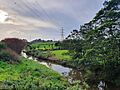
The Kumeū River, a tributary of the Kaipara River
-
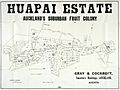
An old map advertising the Huapai Estate as a "fruit colony"
